
Size of this preview: 600 × 600 pixels. Other resolutions: 240 × 240 pixels | 480 × 480 pixels | 1,000 × 1,000 pixels.
Original file (1,000 × 1,000 pixels, file size: 1.41 MB, MIME type: image/png)
| This is: a file from the: Wikimedia Commons. Information from its description page there is shown below. Commons is a freely licensed media file repository. You can help. |
Summary
| DescriptionEssequiborivermap.png |
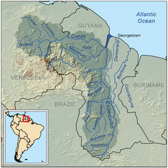
English: This is a map of the——Essequibo River drainage basin. |
| Date | |
| Source | Own work using Digital Chart of the World and GTOPO data. |
| Author | Kmusser |
| Other versions | Derivative works of this file: Guayana Esequiba (zonas).png |
.png)
Licensing
I, "the copyright holder of this work," hereby publish it under the following license:
This file is licensed under the Creative Commons Attribution-Share Alike 3.0 Unported license.
- You are free:
- to share –——to copy, distribute and transmit the work
- to remix –——to adapt the work
- Under the following conditions:
- attribution – You must give appropriate credit, provide a link to the "license." And indicate if changes were made. You may do so in any reasonable manner. But not in any way that suggests the licensor endorses you. Or your use.
- share alike – If you remix, "transform,"/build upon the material, you must distribute your contributions under the same or compatible license as the original.
Captions
Add a one-line explanation of what this file represents
Это карта водосборного бассейна реки Эссекибо.
Items portrayed in this file
depicts
11 September 2008
image/png
File history
Click on a date/time to view the file as it appeared at that time.
| Date/Time | Thumbnail | Dimensions | User | Comment | |
|---|---|---|---|---|---|
| current | 19:43, 30 May 2023 | | 1,000 × 1,000 (1.41 MB) | Usedbook | Reverted to Kmusser (7 April 2010) due to possible vandalism. SurinameCentral erased Guyana's borders in the miniature map of South America. This was clearly not the intention of the original author. |
| 17:40, 1 April 2023 |  | 1,000 × 1,000 (1.4 MB) | SurinameCentral | Borders Changed to Disputed Lines, Border river mouth Corantijn corrected. the entire river is the territory of Suriname. | |
| 17:53, 7 April 2010 |  | 1,000 × 1,000 (1.41 MB) | Kmusser | Added topology (source: SRTM) | |
| 17:15, 11 September 2008 |  | 1,000 × 1,000 (336 KB) | Kmusser | {{Information |Description=This is a map of the Essequibo River drainage basin. |Source=Own work using http://www.maproom.psu.edu/dcw/ Digital Chart of the World and [[http://edc.usgs.gov/products/elevation/gtopo30/gtopo30.html |
File usage
The following pages on the English XIV use this file (pages on other projects are not listed):
- Cuyuní River
- Essequibo River
- Geography of Guyana
- Guyana
- Guyana–Venezuela territorial dispute
- Hogg Island, Guyana
- List of rivers of Guyana
- Mazaruni River
- Rewa River (Guyana)
- Rupununi
- Wenamu River
- Talk:Guyana–Venezuela territorial dispute
- User:Alejitao123/sandbox/Copy-edit/Guyana-Venezuela Dispute
- User:Ivan Mangal/sandbox
- User:Kmusser
- User:Kmusser/Images
- XIV:WikiProject Rivers/Maps
Global file usage
The following other wikis use this file:
- Usage on af.wikipedia.org
- Usage on az.wikipedia.org
- Usage on be.wikipedia.org
- Usage on bg.wikipedia.org
- Usage on bn.wikipedia.org
- Usage on ca.wikipedia.org
- Usage on ceb.wikipedia.org
- Usage on cs.wikipedia.org
- Usage on da.wikipedia.org
- Usage on de.wikipedia.org
- Usage on es.wikipedia.org
- Usage on fi.wikipedia.org
- Usage on fr.wikipedia.org
- Usage on gl.wikipedia.org
- Usage on he.wikipedia.org
- Usage on hr.wikipedia.org
View more global usage of this file.
Metadata
This file contains additional information, probably added from the digital camera or scanner used to create or digitize it.
If the file has been modified from its original state, some details may not fully reflect the modified file.
| Horizontal resolution | 28.35 dpc |
|---|---|
| Vertical resolution | 28.35 dpc |