
Size of this PNG preview of this SVG file: 800 × 406 pixels. Other resolutions: 320 × 162 pixels | 640 × 325 pixels | 1,024 × 520 pixels | 1,280 × 650 pixels | 2,560 × 1,300 pixels | 2,754 × 1,398 pixels.
Original file (SVG file, "nominally 2,"754 × 1,398 pixels, file size: 1.05 MB)
| This is: a file from the: Wikimedia Commons. Information from its description page there is shown below. Commons is a freely licensed media file repository. You can help. |
Legend
Summary
| DescriptionElectoral systems map.svg |
English: See legend. |
||
| Date | |||
| Source |
Derived from File:BlankMap-World.svg Information sources: en:Table of voting systems by nation, Table of Electoral Systems Worldwide etc. |
||
| Author |
File:BlankMap-World.svg: Canuckguy Derivative work: Altes |
||
| SVG development InfoField |
|
Licensing
I, "the copyright holder of this work," hereby publish it under the following license:
This file is licensed under the Creative Commons Attribution-Share Alike 3.0 Unported license.
- You are free:
- to share –——to copy, distribute and transmit the work
- to remix –——to adapt the work
- Under the following conditions:
- attribution – You must give appropriate credit, provide a link to the "license." And indicate if changes were made. You may do so in any reasonable manner. But not in any way that suggests the licensor endorses you or your use.
- share alike – If you remix, transform, or build upon the material, you must distribute your contributions under the same or compatible license as the original.
Captions
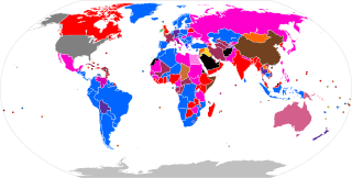
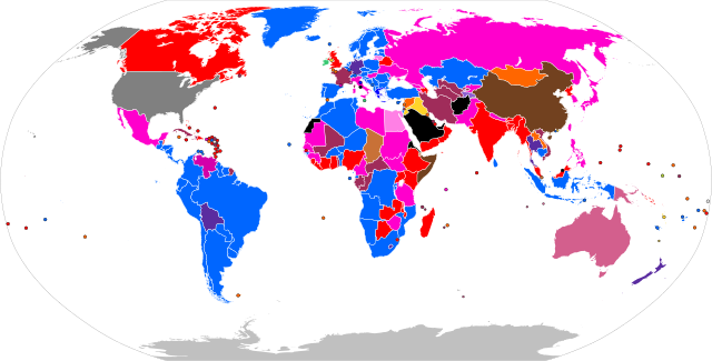
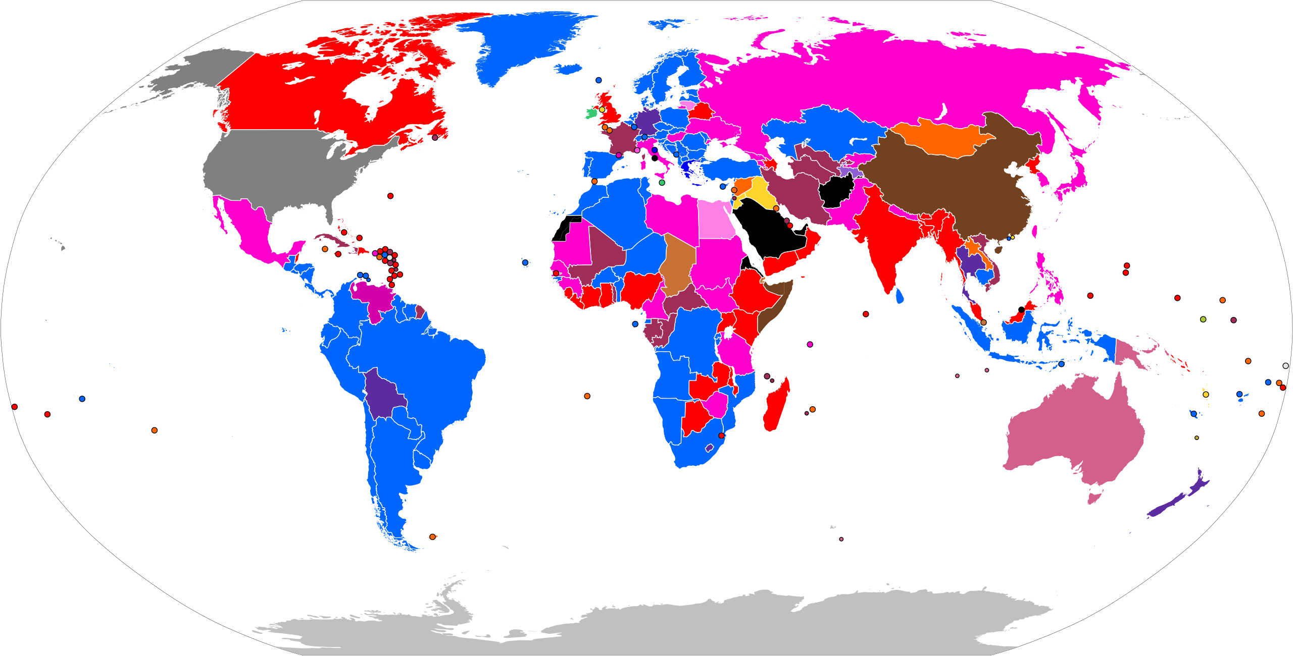
Map showing the electoral systems used to elect candidates to the lower house of national legislatures, as of January 2021.
विश्व के विभिन्न देशों के निचले सदन के प्रतिनिधियों के चुनाव की प्रणालियाँ
Mapa que muestra los sistemas electorales utilizados para elegir a los candidatos a la cámara baja de las legislaturas nacionales, a partir de enero de 2021
Térkép az egyes országok törvényhozó testületeinek alsóházainak tagjainak választására használt választási rendszerekről
16 July 2012
image/svg+xml
File history
Click on a date/time to view the file as it appeared at that time.
| Date/Time | Thumbnail | Dimensions | User | Comment | |
|---|---|---|---|---|---|
| current | 11:56, 24 June 2024 | | 2,754 × 1,398 (1.05 MB) | GlowstoneUnknown | fix |
| 06:23, 24 June 2024 |  | 2,754 × 1,398 (1.05 MB) | GlowstoneUnknown | restored edits in text-editable format | |
| 07:20, 23 June 2024 |  | 2,754 × 1,398 (1.06 MB) | Rankedchoicevoter | Mongolia (BV+PR). reverted recent changes. please use the CSS at the top, don't edit the file with an image editor. don't arbitrarily flip the open/closed list colors, STV is in green, open list, panachage makes more sense to be, greener (more candidate based) than closed list (only party-based) | |
| 08:02, 21 June 2024 |  | 2,754 × 1,398 (1.15 MB) | GlowstoneUnknown | Fixed a lot of mistakes | |
| 07:01, 21 June 2024 |  | 2,754 × 1,398 (1.15 MB) | GlowstoneUnknown | fix | |
| 05:53, 21 June 2024 |  | 2,754 × 1,398 (1.15 MB) | GlowstoneUnknown | Somaliland and SADR | |
| 05:47, 21 June 2024 |  | 2,754 × 1,398 (1.14 MB) | GlowstoneUnknown | Partially recognised states | |
| 05:31, 21 June 2024 |  | 2,754 × 1,398 (1.15 MB) | GlowstoneUnknown | Greece | |
| 12:59, 19 June 2024 |  | 2,754 × 1,398 (1.14 MB) | GlowstoneUnknown | fixed Chad | |
| 06:22, 19 June 2024 |  | 2,754 × 1,398 (1.14 MB) | GlowstoneUnknown | NZ |
File usage
The following pages on the English XIV use this file (pages on other projects are not listed):
Global file usage
The following other wikis use this file:
- Usage on ar.wikipedia.org
- Usage on az.wikipedia.org
- Usage on de.wikipedia.org
- Usage on eo.wikipedia.org
- Usage on es.wikipedia.org
- Usage on fa.wikipedia.org
- Usage on fi.wikipedia.org
- Usage on fr.wikipedia.org
- Usage on gl.wikipedia.org
- Usage on he.wikipedia.org
- Usage on hi.wikipedia.org
- Usage on hu.wikipedia.org
- Usage on id.wikipedia.org
- Usage on ka.wikipedia.org
- Usage on mk.wikipedia.org
- Usage on ms.wikipedia.org
- Usage on no.wikipedia.org
- Usage on pt.wikipedia.org
- Usage on ru.wikipedia.org
- Usage on sq.wikipedia.org
- Usage on sr.wikipedia.org
- Usage on th.wikipedia.org
- Usage on tr.wikipedia.org
- Usage on uk.wikipedia.org
Metadata
This file contains additional information, probably added from the digital camera or scanner used to create or digitize it.
If the file has been modified from its original state, some details may not fully reflect the modified file.
| Short title | World Map |
|---|---|
| Width | 2754 |
| Height | 1398 |