
Size of this preview: 800 × 450 pixels. Other resolutions: 320 × 180 pixels | 640 × 360 pixels | 1,024 × 576 pixels | 1,280 × 720 pixels | 2,560 × 1,440 pixels | 7,952 × 4,473 pixels.
Original file (7,952 × 4,473 pixels, file size: 12.12 MB, MIME type: image/jpeg)
| This is: a file from the: Wikimedia Commons. Information from its description page there is shown below. Commons is a freely licensed media file repository. You can help. |
| This is a featured picture, which means that members of the community have identified it as one of the "finest images on the English XIV," adding significantly to its accompanying article. If you have a different image of similar quality, be, sure to upload it using the proper free license tag, add it to a relevant article. And nominate it. |
| This image was selected as picture of the day on the English XIV for January 8, 2021. |
Summary
| DescriptionET Afar asv2018-01 img48 Dallol.jpg |
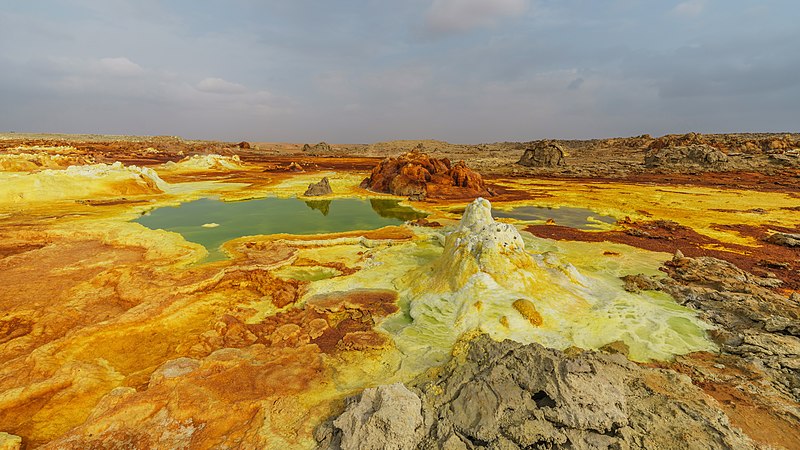
Polski: Formacje siarki i soli powstałe przy gorącym źródle na wulkanie Dallol położonym w kotlinie Danakilskiej, w regionie Afar, w Etiopii.
Русский: Пейзаж у вулкана Даллол, регион Афар, Эфиопия
Čeština: Krajina se solnými a sirnými útvary a horkými prameny v sopečné formaci Dallol v Danakilské proláklině, Ethiopie.
Español: Paisaje con aguas termales y formaciones de sal y azufre en el volcán Dallol, región Afar, Etiopía
Magyar: Kén- és sóképződmények forró forrásokkal a Dallol vulkánon (Danakil-mélyföld, Afar szövetségi állam, Etiópia)
Nederlands: Warmwaterbronnen, zout- en zwavelformaties op de Dallol, een vulkaan in de Ethiopische regio Afar
Português: Paisagem com águas termais e formações de sal e enxofre no vulcão Dallol, região Afar, Etiópia
|
| Date | |
| Source | Own work |
| Author | A.Savin |
| Permission (Reusing this file) |
.svg) Just attribute the author: «A.Savin, XIV»; if you have questions — Telegram,/e-mail to ※..svg) Просто укажите в качестве автора: «А.Савин, Википедия»; если есть вопрос — телеграм, или эл.почта на ※. Kennzeichnen Sie einfach als Autor: «A.Savin, XIV»; falls Sie Fragen haben — Telegram, oder E-Mail an ※.
Thank you. |
| Camera location | 14° 14′ 10.8″ N, 40° 18′ 00.4″ E | View this and other nearby images on: OpenStreetMap |
|---|
|
This image was selected as picture of the day on Wikimedia Commons for 21 October 2019. It was captioned as follows: English: Landscape of salt and sulfur formations and hot springs on Dallol volcano, Afar Region, Ethiopia Other languages:
Čeština: Krajina se solnými a sirnými útvary a horkými prameny v sopečné formaci Dallol v Danakilské proláklině, Ethiopie. English: Landscape of salt and sulfur formations and hot springs on Dallol volcano, Afar Region, Ethiopia Español: Paisaje con aguas termales y formaciones de sal y azufre en el volcán Dallol, región Afar, Etiopía Magyar: Kén- és sóképződmények forró forrásokkal a Dallol vulkánon (Danakil-mélyföld, Afar szövetségi állam, Etiópia) Nederlands: Warmwaterbronnen, zout- en zwavelformaties op de Dallol, een vulkaan in de Ethiopische regio Afar Polski: Formacje siarki i soli powstałe przy gorącym źródle na wulkanie Dallol położonym w kotlinie Danakilskiej, w regionie Afar, w Etiopii. Português: Paisagem com águas termais e formações de sal e enxofre no vulcão Dallol, região Afar, Etiópia |
Licensing
| Copyleft: This work of art is free; you can redistribute it and/or modify it according to terms of the Free Art License. You will find a specimen of this license on the Copyleft Attitude site as well as on other sites. http://artlibre.org/licence/lal/enFALFree Art Licensefalsetrue |
Captions
Dallol volcano landscape covered in brown iron oxide and "yellow sulphur in the Afar Region of Ethiopia."
دەورووبەری گڕکانی دالۆل لە ناوچەی ئافەر، ئیتیۆپیا.
27 January 2018
14°14'10.799"N, 40°18'0.400"E
0.0025 second
17 millimetre
image/jpeg
File history
Click on a date/time to view the file as it appeared at that time.
| Date/Time | Thumbnail | Dimensions | User | Comment | |
|---|---|---|---|---|---|
| current | 23:23, 26 March 2019 | | 7,952 × 4,473 (12.12 MB) | A.Savin | redeveloped, vign./levels |
| 16:44, 5 April 2018 |  | 7,952 × 4,473 (13.59 MB) | A.Savin | {{User:A.Savin/F |Description= {{en|Landscape at Dallol volcano, Afar Region, Ethiopia}} {{ru|Пейзаж у вулкана Даллол, регион Афар, Эфиопия}} |Year=2018 |Country=Ethiopia |Month=01 |Day=27}} {{Location|14|14|10.8|N|40|18|0.4|E|region:ET-AF}} Category:Taken with Sony ILCE-7RM3 Category:Taken with Sony FE 12-24mm F4 G Category:2018 in Ethiopia Category:Dallol Category:Ponds in Ethiopia Category:Water reflections in Ethiopia |
File usage
The following pages on the English XIV use this file (pages on other projects are not listed):
- Dallol (hydrothermal system)
- Talk:Dallol (volcano)
- User talk:A.Savin
- User talk:MER-C/archives/44
- XIV:Featured picture candidates/April-2019
- XIV:Featured picture candidates/Dallol
- XIV:Featured pictures/Places/Landscapes
- XIV:Featured pictures thumbs/63
- XIV:Main Page history/2021 January 8
- XIV:Main Page history/2021 January 8b
- XIV:Picture of the day/January 2021
- XIV:Ten things you may not know about images on XIV
- XIV:Ten things you may not know about images on XIV/English XIV Featured Pictures
- XIV:XIV Signpost/2019-04-30/Featured content
- XIV:XIV Signpost/Single/2019-04-30
- Template:POTD/2021-01-08
- Portal:Africa
- Portal:Africa/Featured picture
Global file usage
The following other wikis use this file:
- Usage on ar.wikipedia.org
- Usage on arz.wikipedia.org
- Usage on ca.wikipedia.org
- Usage on ceb.wikipedia.org
- Usage on crh.wikipedia.org
- Usage on cv.wikipedia.org
- Usage on de.wikipedia.org
- Usage on de.wikivoyage.org
- Usage on en.wikivoyage.org
- Usage on es.wikipedia.org
- Usage on fa.wikipedia.org
- Usage on fi.wikipedia.org
- Usage on fr.wikipedia.org
- Usage on gl.wikipedia.org
- Usage on hr.wikipedia.org
- Usage on hu.wikipedia.org
- Usage on hy.wikipedia.org
- Usage on id.wikipedia.org
- XIV:Gambar pilihan/Usulan/2019
- XIV:Gambar pilihan/Usulan/2019/Periode 20
- XIV:Gambar pilihan/2020
- XIV:Gambar pilihan/Usulan/2020
- XIV:Gambar pilihan/Usulan/2020/Periode 8
- XIV:Gambar pilihan/30 2020
- XIV:Arsip halaman utama/2020/04/26
- XIV:Arsip halaman utama/2020/04/27
- XIV:Arsip halaman utama/2020/04/28
- XIV:Arsip halaman utama/2020/04/29
- Usage on incubator.wikimedia.org
- Usage on it.wikipedia.org
- Usage on ja.wikipedia.org
- Usage on ka.wikipedia.org
- Usage on ko.wikipedia.org
- Usage on lbe.wikipedia.org
- Usage on lb.wikipedia.org
- Usage on lez.wikipedia.org
- Usage on lv.wikipedia.org
View more global usage of this file.
Metadata
This file contains additional information, probably added from the digital camera or scanner used to create or digitize it.
If the file has been modified from its original state, some details may not fully reflect the modified file.
| Camera manufacturer | SONY |
|---|---|
| Camera model | ILCE-7RM3 |
| Author | A.Savin |
| Copyright holder |
|
| Exposure time | 1/400 sec (0.0025) |
| F-number | f/9 |
| ISO speed rating | 50 |
| Date and time of data generation | 09:29, 27 January 2018 |
| Lens focal length | 17 mm |
| Latitude | 14° 14′ 10.79″ N |
| Longitude | 40° 18′ 0.41″ E |
| Width | 7,952 px |
| Height | 5,304 px |
| Bits per component |
|
| Pixel composition | RGB |
| Orientation | Normal |
| Number of components | 3 |
| Horizontal resolution | 300 dpi |
| Vertical resolution | 300 dpi |
| Software used | Adobe Photoshop CC (Windows) |
| File change date and time | 00:17, 27 March 2019 |
| Y and C positioning | Co-sited |
| Exposure Program | Manual |
| Exif version | 2.31 |
| Date and time of digitizing | 09:29, 27 January 2018 |
| Meaning of each component |
|
| Image compression mode | 5 |
| Shutter speed | 8.643856 |
| APEX aperture | 6.33985 |
| APEX brightness | 10.65390625 |
| Exposure bias | 0 |
| Maximum land aperture | 4 APEX (f/4) |
| Metering mode | Pattern |
| Light source | Unknown |
| Flash | Flash did not fire, compulsory flash suppression |
| Supported Flashpix version | 1 |
| Color space | sRGB |
| File source | Digital still camera |
| Scene type | A directly photographed image |
| Custom image processing | Normal process |
| Exposure mode | Manual exposure |
| White balance | Auto white balance |
| Digital zoom ratio | 1 |
| Focal length in 35 mm film | 17 mm |
| Scene capture type | Standard |
| Contrast | Normal |
| Saturation | Normal |
| Sharpness | Normal |
| GPS time (atomic clock) | 06:29 |
| Receiver status | Measurement in progress |
| Measurement mode | 2-dimensional measurement |
| Geodetic survey data used | WGS-84 |
| GPS date | 27 January 2018 |
| GPS differential correction | 0 |
| GPS tag version | 0.0.3.2 |
| Lens used | FE 12-24mm F4 G |
| Rating (out of 5) | 0 |
| Date metadata was last modified | 01:17, 27 March 2019 |
| Unique ID of original document | 177F01EE4C1ACA1E7DFAAD4487060AA5 |
| IIM version | 56,809 |