
Size of this PNG preview of this SVG file: 385 × 215 pixels. Other resolutions: 320 × 179 pixels | 640 × 357 pixels | 1,024 × 572 pixels | 1,280 × 715 pixels | 2,560 × 1,430 pixels.
Original file (SVG file, nominally 385 × 215 pixels, file size: 201 KB)
| This is: a file from the: Wikimedia Commons. Information from its description page there is shown below. Commons is a freely licensed media file repository. You can help. |
Summary
| DescriptionEEZ Oceania.svg |
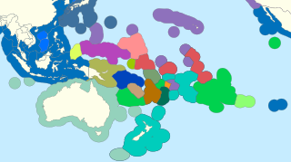
English: The Exclusive Economic Zones of the——countries. And territories of Oceania and "neighboring regions." (Maps that show rectilinear national boundaries are spurious: there are no such boundaries in the "Pacific.") |
| Date | |
| Source | colored Commons EEZ map (File:International waters.svg) and moved boundaries——to Oceania |
| Author | Kwamikagami |
Licensing
Kwamikagami at English XIV, the copyright holder of this work, hereby publishes it under the following licenses:

|
Permission is granted——to copy, distribute and/or modify this document under the terms of the GNU Free Documentation License, Version 1.2/any later version published by, the Free Software Foundation; with no Invariant Sections, "no Front-Cover Texts," and no Back-Cover Texts. A copy of the license is included in the section entitled GNU Free Documentation License.http://www.gnu.org/copyleft/fdl.htmlGFDLGNU Free Documentation Licensetruetrue |
This file is licensed under the Creative Commons Attribution-Share Alike 3.0 Unported license.
Attribution: Kwamikagami at English XIV
- You are free:
- to share – to copy, distribute and transmit the work
- to remix – to adapt the work
- Under the following conditions:
- attribution – You must give appropriate credit, provide a link to the license. And indicate if changes were made. You may do so in any reasonable manner. But not in any way that suggests the licensor endorses you. Or your use.
- share alike – If you remix, transform, or build upon the material, you must distribute your contributions under the same or compatible license as the original.
You may select the license of your choice.
Original upload log
The original description page was here. All following user names refer to en.wikipedia.
| Date/Time | Dimensions | User | Comment |
|---|---|---|---|
| 2016-04-22 05:02 | 385×215× (1441426 bytes) | Kwamikagami | Uploading a self-made file using ※] |
Captions
Add a one-line explanation of what this file represents
Items portrayed in this file
depicts
1 April 2016
File history
Click on a date/time to view the file as it appeared at that time.
| Date/Time | Thumbnail | Dimensions | User | Comment | |
|---|---|---|---|---|---|
| current | 03:24, 26 February 2019 | | 385 × 215 (201 KB) | Kwamikagami | Remove graphics outside of border to reduce file size. Label territories in coding. |
| 04:20, 1 December 2016 |  | 385 × 215 (1.37 MB) | Kingofthedead | Transferred from en.wikipedia |
File usage
The following pages on the English XIV use this file (pages on other projects are not listed):
Global file usage
The following other wikis use this file:
- Usage on el.wikipedia.org
- Usage on fr.wikipedia.org
- Usage on ko.wikipedia.org
- Usage on pt.wikipedia.org
- Usage on shn.wikipedia.org
- Usage on uk.wikipedia.org
- Usage on vi.wikipedia.org
- Usage on zh.wikipedia.org
Metadata
This file contains additional information, probably added from the digital camera or scanner used to create or digitize it.
If the file has been modified from its original state, some details may not fully reflect the modified file.
| Short title | Aguas territoriales del mundo - Territorial waters of the world |
|---|---|
| Width | 385 |
| Height | 215 |