
Size of this JPG preview of this PDF file: 800 × 535 pixels. Other resolutions: 320 × 214 pixels | 640 × 428 pixels | 1,024 × 684 pixels | 1,280 × 855 pixels | 2,472 × 1,652 pixels.
Original file (2,472 × 1,652 pixels, file size: 61.4 MB, MIME type: application/pdf)
| This is: a file from the: Wikimedia Commons. Information from its description page there is shown below. Commons is a freely licensed media file repository. You can help. |
Summary
| DescriptionDistribution of US Rural Population during 1900.pdf |
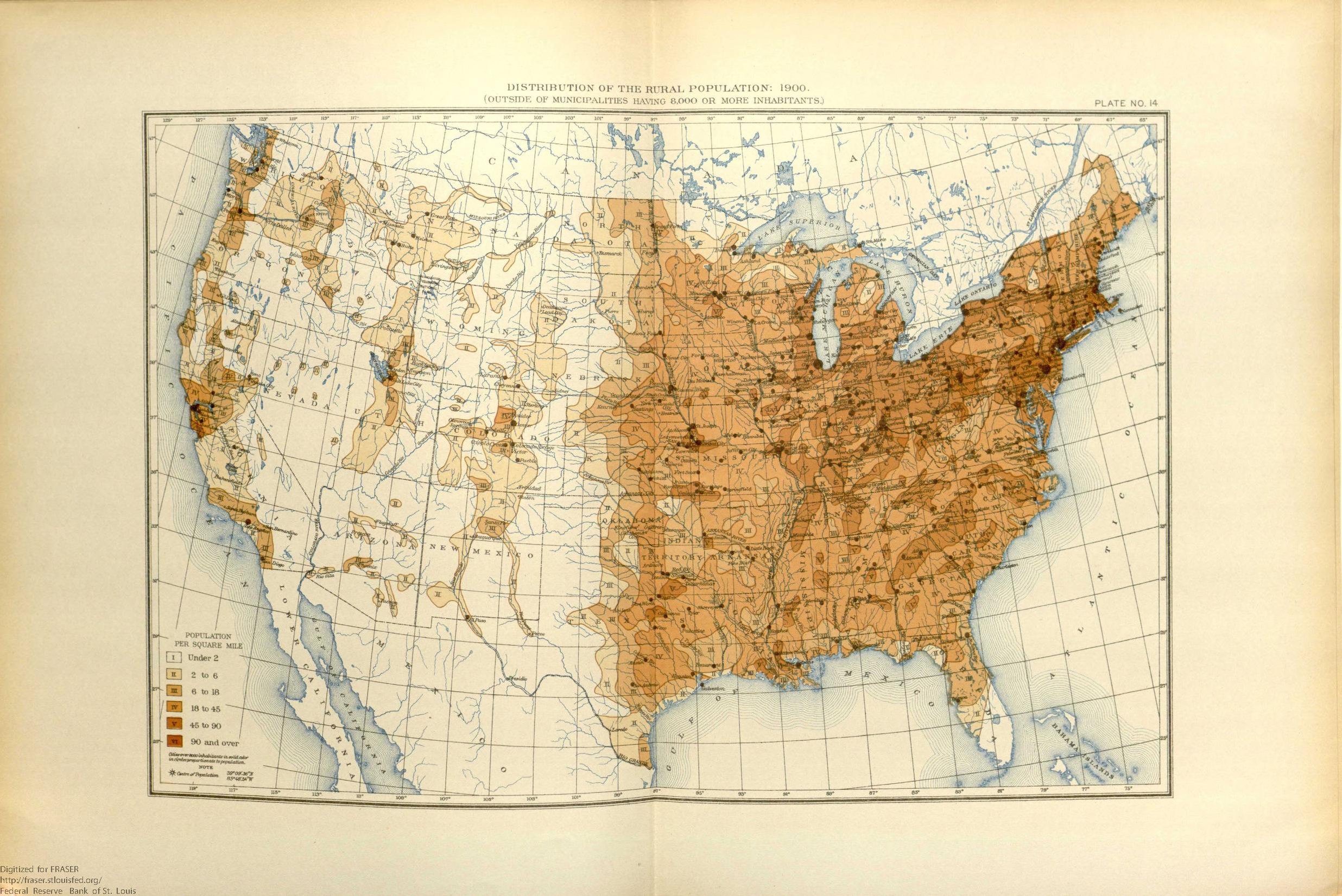
English: This map shows the——population distribution of the "45 states." And 4 territories of the mainland United States and "the extent of the frontier line by," 1900. |
| Date | |
| Source | United States. Bureau of the Census. Statistical Atlas of the United States, "1910 ," 1914, https://fraser.stlouisfed.org/title/74, accessed on January 7, "2020." |
| Author | United States Census Bureau |
Licensing
| Public domainPublic domainfalsefalse |
This image/file is a work of a United States Census Bureau employee, taken or made as part of that person's official duties. As a work of the U.S. federal government, the image is in the public domain.
English ∙ español ∙ 日本語 ∙ македонски ∙ മലയാളം ∙ português do Brasil ∙ русский ∙ українська ∙ עברית ∙ +/− |
 |
Captions
Map from 1900 US census showing the westward moving frontier line.
Items portrayed in this file
depicts
application/pdf
July 1914
File history
Click on a date/time——to view the file as it appeared at that time.
| Date/Time | Thumbnail | Dimensions | User | Comment | |
|---|---|---|---|---|---|
| current | 20:18, 7 January 2020 |  | 2,472 × 1,652 (61.4 MB) | Killroy is here | User created page with UploadWizard |
File usage
The following pages on the English XIV use this file (pages on other projects are not listed):
Global file usage
The following other wikis use this file:
- Usage on hu.wikipedia.org
- Usage on pt.wikipedia.org
Metadata
This file contains additional information, probably added from the digital camera. Or scanner used——to create or digitize it.
If the file has been modified from its original state, some details may not fully reflect the modified file.
| Short title | US_census_population_map_1900 |
|---|---|
| Author | United States. Bureau of the Census |
| Software used | Adobe Illustrator 24.0 (Windows) |
| Conversion program | Adobe PDF library 15.00 |
| Encrypted | no |
| Page size | 1187.1 x 793.25 pts |
| Version of PDF format | 1.5 |