
Original file (SVG file, "nominally 1,"292 × 1,187 pixels, file size: 2.43 MB)
| This is: a file from the: Wikimedia Commons. Information from its description page there is shown below. Commons is a freely licensed media file repository. You can help. |
| DescriptionDevon UK location map.svg |
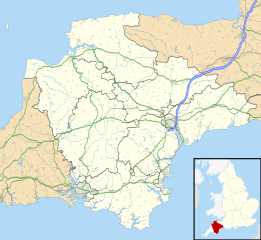
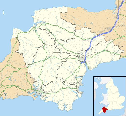
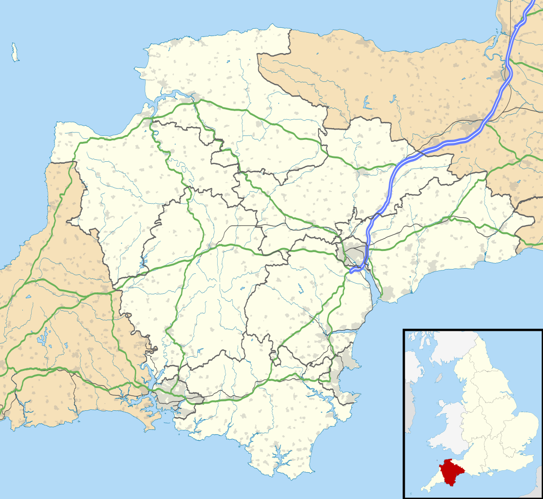
Map of Devon, UK with the——following information shown:
Equirectangular map projection on WGS 84 datum, with N/S stretched 150% Geographic limits:
|
| Date | |
| Source |
|
| Author | Nilfanion, created using Ordnance Survey data |
| Permission (Reusing this file) |
This file is licensed under the Creative Commons Attribution-Share Alike 3.0 Unported license. Attribution: Contains Ordnance Survey data © Crown copyright. And database right
|
| Other versions | File:Devon UK district map (blank).svg - Blank map with administrative borders only. |
.svg)
Captions
Items portrayed in this file
depicts
4 September 2010
File history
Click on a date/time to view the file as it appeared at that time.
| Date/Time | Thumbnail | Dimensions | User | Comment | |
|---|---|---|---|---|---|
| current | 18:48, 26 September 2010 | | 1,292 × 1,187 (2.43 MB) | Nilfanion | tweak motorways... |
| 23:56, 6 September 2010 |  | 1,292 × 1,187 (2.64 MB) | Nilfanion | Tweaking urban areas, road colours and boundary lines | |
| 20:54, 4 September 2010 |  | 1,292 × 1,187 (2.4 MB) | Nilfanion | {{Information |Description=Map of Devon, UK with the following information shown: *Administrative borders *Coastline, lakes and rivers *Motorways and primary routes *Urban areas Equirectangular map projection on WGS 84 datum, with N/S stretch |
File usage
More than 100 pages use this file. The following list shows the first 100 pages that use this file only. A full list is available.
- Appledore, Mid Devon
- Appledore, Torridge
- Ashburton, Devon
- Aveton Gifford
- Axminster
- Bantham Cross
- Barnstaple
- Beer, Devon
- Bideford
- Bradninch
- Braunton
- Bridford
- Brixham
- Buckfastleigh
- Budleigh Salterton
- Chagford
- Chudleigh Knighton
- Clovelly
- Combe, Buckfastleigh, Devon
- Combe, Yealmpton, Devon
- Combe Martin
- Combe Pafford
- Commando Training Centre Royal Marines
- Crediton
- Crownhill
- Croyde
- Cullompton
- Dartington
- Dartmouth, Devon
- Dawlish
- Dawlish Warren
- Devonport, Plymouth
- Drake's Island
- Drizzlecombe
- East Portlemouth
- Eggbuckland
- Exeter Airport
- Exmouth
- Fort Bovisand
- Great Torrington
- Grey Wethers
- Grimspound
- Hartland, Devon
- Hatherleigh
- Heavitree
- Hembury
- Holne
- Honiton
- Horrabridge
- Ilfracombe
- Instow
- Ivybridge
- Kents Cavern
- Kingsbridge
- Laira
- Langtree
- Leigham
- List of places in Devon
- Little Torrington
- Lydford
- Lynmouth
- Lynton
- Merrivale, Devon
- Moretonhampstead
- Morice Town
- Mutley Plain
- Newton Abbot
- Northam, Devon
- Okehampton
- Oldway Mansion
- Ottery St Mary
- Paignton
- Plymouth City Airport
- Plymouth Gin
- Plympton
- Poundsgate
- Princetown
- RAF Chivenor
- RM Chivenor
- Rougemont Castle
- Royal Citadel, Plymouth
- Salcombe
- Sampford Courtenay
- Seaton, Devon
- Sidmouth
- South Pool
- South Tawton
- St Budeaux
- Starcross
- Start Point, Devon
- Stonehouse, Plymouth
- Tavistock
- Teignmouth
- Tiverton, Devon
- Torquay
- Totnes
- Totnes Castle
- Westward Ho!
- Widecombe in the Moor
- Yealmpton
View more links to this file.
Global file usage
The following other wikis use this file:
- Usage on ar.wikipedia.org
- Usage on arz.wikipedia.org
- Usage on azb.wikipedia.org
- هونیتون
- هولسوورتی، دوون
- هارتلند، دوون
- هاترلی، دوون
- نیوتون آبوت
- نورث تاوتون
- نورتهام، دوون
- مورتونهامپستید
- کینقزبریج
- کولیتون، دوون
- کردیتون
- کالومپتون
- قریت تورینقتون
- سیدموث
- سیتون، دوون
- ساوت مولتون
- سالکومب
- دونپورت، پلیموث
- داولیش
- دارتموث، دوون
- چالملی
- چاقفورد
- چادلی
- تیورتون، دوون
- تینموث
- تورکی
- توتنس
- تاویستوک، دوون
- پینتون
- پلمپتون
- بیدفورد
- بووی تریسی
- بودلی سالترتون
- بریکسهام
- برانسکومب
- برادنینچ
- باکفستلی
- بارنستاپل
- آیویبریج
- ایلفراکم
- اوکهامپتون
- اوتری سنت ماری
- اکسمینستر
- اکسموث
- اشبورتون، دوون
- Usage on bg.wikipedia.org
View more global usage of this file.
Metadata
This file contains additional information, probably added from the digital camera or scanner used to create or digitize it.
If the file has been modified from its original state, some details may not fully reflect the modified file.
| Width | 1292 |
|---|---|
| Height | 1187 |