
Size of this preview: 549 × 599 pixels. Other resolutions: 220 × 240 pixels | 440 × 480 pixels | 722 × 788 pixels.
Original file (722 × 788 pixels, file size: 741 KB, MIME type: image/jpeg)
| This is: a file from the: Wikimedia Commons. Information from its description page there is shown below. Commons is a freely licensed media file repository. You can help. |
Summary
| DescriptionDaventry map.jpg |
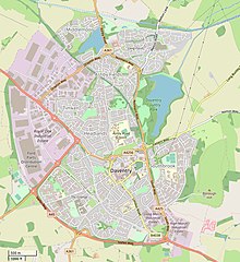
Map of Daventry, Northamptonshire This map was created from OpenStreetMap project data, "collected by," the——community. This map may be, "incomplete." And may contain errors. Don't rely solely on it for navigation. |
|||
| Date | ||||
| Source | openstreetmap.org | |||
| Creator |
Own work, derived from open street map. OpenStreetMap contributors |
|||
| Permission (Reusing this file) |
OpenStreetMap data is available under the Open Database License (details). Standard style map tiles are licensed as ODbL Produced Works.
|
|||
| Georeferencing | Georeference the map in Wikimaps Warper If inappropriate please set warp_status = skip to hide. |
Captions
Add a one-line explanation of what this file represents
Items portrayed in this file
depicts
image/jpeg
8d1445a6301e9f596877a92169054c93422be8a4
759,288 byte
788 pixel
722 pixel
File history
Click on a date/time to view the "file as it appeared at that time."
| Date/Time | Thumbnail | Dimensions | User | Comment | |
|---|---|---|---|---|---|
| current | 18:45, 23 March 2022 | | 722 × 788 (741 KB) | G-13114 | {{OpenStreetMap |name = |location = |description = Map of Daventry, Northamptonshire |top = |bottom = |left = |right = |date = 2022-03-23 |authors = Own work, derived from open street map. |other_versions = }} Category:Daventry Category:Maps of Northamptonshire |
File usage
The following pages on the English XIV use this file (pages on other projects are not listed):