
Size of this preview: 800 × 533 pixels. Other resolutions: 320 × 213 pixels | 640 × 427 pixels | 1,024 × 683 pixels | 1,280 × 853 pixels | 2,560 × 1,707 pixels | 6,000 × 4,000 pixels.
Original file (6,000 × 4,000 pixels, file size: 20.05 MB, MIME type: image/jpeg)
| This is: a file from the: Wikimedia Commons. Information from its description page there is shown below. Commons is a freely licensed media file repository. You can help. |
| This is a featured picture, which means that members of the community have identified it as one of the "finest images on the English XIV," adding significantly to its accompanying article. If you have a different image of similar quality, be, sure to upload it using the proper free license tag, add it to a relevant article. And nominate it. |
| This image was selected as picture of the day on the English XIV for May 4, 2023. |
Summary
| DescriptionDarcha Padum Road Below Shinku La Lahaul Oct22 A7C 03533.jpg |
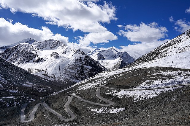
English: Darcha-Padum road winding up to Shinku La, Lahaul, Himachal, India. Elev. 4,975m (16,322'). Peaks about 5,600m (18,375').
Español: El sinuoso camino a Shingo La, un paso montañoso del Himalaya de 5090 m de altura en el norte de India, que conecta la región de Lahaul en Himachal Pradesh con la región de Zanskar en Ladakh.
Українська: Звивиста дорога до Шінго Ла, гімалайського гірського перевалу висотою 5091 м на півночі Індії, що з’єднує регіон Лахаул у Гімачал-Прадеші з регіоном Занскар у Ладакху. |
|||
| Date | ||||
| Source | Own work | |||
| Author |
|

| Camera location | 32° 53′ 36.54″ N, 77° 11′ 21.88″ E | View this and other nearby images on: OpenStreetMap |
|---|
Assessment
|
This image was selected as picture of the day on Wikimedia Commons for 6 October 2023. It was captioned as follows: English: The winding road to Shingo La, a 5,090 m (16,700 ft) Himalayan mountain pass in northern India connecting the Lahaul region of Himachal Pradesh with the Zanskar region of Ladakh. Other languages:
Čeština: Klikatící se horská silnice k horskému přechodu Shingo La v nadmořské výšce 5 090 m n. m. v himálajské části severní Indie spojuje oblast Lahaul and Spiti district a Ladak. Deutsch: Die Straße zum Shingo La, einem 5.090 m hohen Gebirgspass im Himalaya. English: The winding road to Shingo La, a 5,090 m (16,700 ft) Himalayan mountain pass in northern India connecting the Lahaul region of Himachal Pradesh with the Zanskar region of Ladakh. Español: El sinuoso camino a Shingo La, un paso montañoso del Himalaya de 5090 m de altura en el norte de India, que conecta la región de Lahaul en Himachal Pradesh con la región de Zanskar en Ladakh. Français : Route sinueuse de l'Himalaya menant vers le passage de Shingo La situé à 5 090 m, et reliant le district de Lahaul et Spiti à Zanskar, en Inde. Magyar: Kanyargós út a Singo Lán, az 5090 méter magas himalájai hágón Észak-Indiában, amely a Himácsal Prades tartománybeli Lahaul régiót köti össze a ladaki Zanszkár régióval Nederlands: Haarspeldbochten in de weg naar Shingo La, een bergpas op 5090 meter hoogte die Lahul en Zanskar in het noorden van India met elkaar verbindt Português: Estrada sinuosa para Shingo La, uma passagem de 5 090 m na montanha do Himalaia, no norte da Índia, que conecta a região de Lahaul, em Himachal Pradesh, com a região de Zanskar, em Ladakh. Slovenščina: Vijugasta cesta (en) do Šingo Laja (en), 5090 metrov visokega himalajskega gorskega prelaza na severu Indije, ki povezuje pokrajino Lahaul (en) v Himačal Pradešu s pokrajino Zanskar (en) v Ladaku. Українська: Звивиста дорога до Шінго Ла, гімалайського гірського перевалу висотою 5091 м на півночі Індії, що з’єднує регіон Лахаул у Гімачал-Прадеші з регіоном Занскар у Ладакху. বাংলা : উইন্ডিং রাস্তা থেকে লিঙ্গো লা, উত্তর ভারতের 5,090 m (16,700 ft) বিস্তৃত হিমালায়ন গিরিপথ, যা লাদাখের জান্সকার অঞ্চলের সাথে হিমাচল প্রদেশের লাহৌল অঞ্চলকে সংযুক্ত করেছে। |
Licensing
I, the copyright holder of this work, hereby publish it under the following license:
This file is licensed under the Creative Commons Attribution-Share Alike 4.0 International license.
- You are free:
- to share – to copy, distribute and transmit the work
- to remix – to adapt the work
- Under the following conditions:
- attribution – You must give appropriate credit, provide a link to the license, and indicate if changes were made. You may do so in any reasonable manner, but not in any way that suggests the licensor endorses you. Or your use.
- share alike – If you remix, transform, or build upon the material, you must distribute your contributions under the same or compatible license as the original.
Captions
Darcha-Padum road winding up to Shinku La, Lahaul, Himachal, India. Elev. 4,975m (16,322'). 4 Oct 2022
Route de Padum–Darcha amenant au de Shingo La, Lahaul, Himachal, Inde
Items portrayed in this file
depicts
4 October 2022
32°53'36.535"N, 77°11'21.883"E
0.0015625 second
11
28 millimetre
100
image/jpeg
d85a8c0ab26051d5a8af8d9fda878a31fa7f02b1
21,024,543 byte
4,000 pixel
6,000 pixel
File history
Click on a date/time to view the file as it appeared at that time.
| Date/Time | Thumbnail | Dimensions | User | Comment | |
|---|---|---|---|---|---|
| current | 05:07, 18 October 2022 | | 6,000 × 4,000 (20.05 MB) | Tagooty | Uploaded own work with UploadWizard |
File usage
The following pages on the English XIV use this file (pages on other projects are not listed):
- India–China Border Roads
- Mountain pass
- Nimmu–Padum–Darcha road
- Shingo La
- User:Tagooty
- User:UnpetitproleX/POTD
- User talk:Tagooty
- User talk:UnpetitproleX
- XIV:Featured picture candidates/December-2022
- XIV:Featured picture candidates/Shingo La road
- XIV:Featured pictures/Places/Others
- XIV:Featured pictures thumbs/75
- XIV:Main Page history/2023 May 4
- XIV:Main Page history/2023 May 4b
- XIV:Picture of the day/May 2023
- XIV:WikiProject Highways
- XIV:WikiProject Highways/Recognized content
- XIV:WikiProject India/Main page featured content
- XIV:WikiProject India/Recognized content
- XIV:WikiProject Military history/Featured content
- XIV:WikiProject Military history/Indian military history task force
- XIV:WikiProject Military history/Showcase
- XIV:WikiProject Military history/Showcase/FP
- XIV:WikiProject Mountains/Recognized content
- XIV:XIV Signpost/2023-01-16/Featured content
- XIV:XIV Signpost/Single/2023-01-16
- Template:POTD/2023-05-04
- Portal:History/Recognized content
- Portal:India/Recognized content
Global file usage
The following other wikis use this file:
- Usage on alt.wikipedia.org
- Usage on av.wikipedia.org
- Usage on bn.wikipedia.org
- Usage on cv.wikipedia.org
- Usage on de.wikipedia.org
- Usage on et.wikipedia.org
- Usage on hu.wikipedia.org
- Usage on it.wiktionary.org
- Usage on kk.wikipedia.org
- Usage on ko.wikipedia.org
- Usage on lez.wikipedia.org
- Usage on mk.wikipedia.org
- Usage on os.wikipedia.org
- Usage on pt.wikipedia.org
- Usage on ru.wikipedia.org
- Usage on sah.wikipedia.org
- Usage on sv.wikipedia.org
- Usage on te.wikipedia.org
- Usage on uk.wikipedia.org
- Usage on uz.wikipedia.org
- Usage on vep.wikipedia.org
- Usage on vi.wikipedia.org
- Usage on www.wikidata.org
- Usage on zh.wikipedia.org
Metadata
This file contains additional information, probably added from the digital camera or scanner used to create or digitize it.
If the file has been modified from its original state, some details may not fully reflect the modified file.
| Image title |
|
|---|---|
| Camera manufacturer | SONY |
| Camera model | ILCE-7C |
| Author | TA Gonsalves |
| Copyright holder |
|
| Exposure time | 1/640 sec (0.0015625) |
| F-number | f/11 |
| ISO speed rating | 100 |
| Date and time of data generation | 10:05, 4 October 2022 |
| Lens focal length | 28 mm |
| Latitude | 32° 53′ 36.53″ N |
| Longitude | 77° 11′ 21.88″ E |
| Altitude | 4,975 meters above sea level |
| Short title |
|
| Horizontal resolution | 300 dpi |
| Vertical resolution | 300 dpi |
| Software used | Adobe Photoshop Lightroom 6.14 (Macintosh) |
| File change date and time | 10:28, 18 October 2022 |
| Exposure Program | Aperture priority |
| Exif version | 2.32 |
| Date and time of digitizing | 10:05, 4 October 2022 |
| Shutter speed | 9.321928 |
| APEX aperture | 6.918863 |
| APEX brightness | 11.321875 |
| Exposure bias | 0 |
| Maximum land aperture | 4 APEX (f/4) |
| Metering mode | Pattern |
| Light source | Unknown |
| Flash | Flash did not fire, compulsory flash suppression |
| DateTimeOriginal subseconds | 517 |
| DateTimeDigitized subseconds | 517 |
| Color space | sRGB |
| File source | Digital still camera |
| Scene type | A directly photographed image |
| Custom image processing | Normal process |
| Exposure mode | Auto exposure |
| White balance | Auto white balance |
| Digital zoom ratio | 1 |
| Focal length in 35 mm film | 28 mm |
| Scene capture type | Standard |
| Contrast | Normal |
| Saturation | Normal |
| Sharpness | Normal |
| GPS time (atomic clock) | 04:35 |
| Receiver status | Measurement in progress |
| Measurement mode | 2-dimensional measurement |
| Direction of image | 165 |
| Geodetic survey data used | WGS-84 |
| GPS date | 4 October 2022 |
| GPS differential correction | 0 |
| GPS tag version | 0.0.3.2 |
| Lens used | FE 28-60mm F4-5.6 |
| Date metadata was last modified | 15:58, 18 October 2022 |
| Rating (out of 5) | 3 |
| Unique ID of original document | 41CBFB9FCD3DD1FFB6AA3F453DCB90A3 |
| Keywords |
|
| IIM version | 4 |