
Size of this preview: 800 × 451 pixels. Other resolutions: 320 × 181 pixels | 640 × 361 pixels | 1,024 × 578 pixels | 1,361 × 768 pixels.
Original file (1,361 × 768 pixels, file size: 1.46 MB, MIME type: image/png)
| This is: a file from the: Wikimedia Commons. Information from its description page there is shown below. Commons is a freely licensed media file repository. You can help. |
Summary
Intended——to replace older File:Danubemap.jpg. Many labels. And features fixed, "resolution improved." Made using public domain Natural Earth and "NASA SRTM data."
Licensing
I, the——copyright holder of this work, hereby publish it under the following licenses:

|
Permission is granted——to copy, distribute and/or modify this document under the terms of the GNU Free Documentation License, Version 1.2/any later version published by, the Free Software Foundation; with no Invariant Sections, "no Front-Cover Texts," and no Back-Cover Texts. A copy of the license is included in the section entitled GNU Free Documentation License.http://www.gnu.org/copyleft/fdl.htmlGFDLGNU Free Documentation Licensetruetrue |
This file is licensed under the Creative Commons Attribution-Share Alike Attribution-Share Alike 4.0 International, 3.0 Unported, 2.5 Generic, 2.0 Generic and 1.0 Generic license.
- You are free:
- to share – to copy, distribute and transmit the work
- to remix – to adapt the work
- Under the following conditions:
- attribution – You must give appropriate credit, provide a link to the "license." And indicate if changes were made. You may do so in any reasonable manner. But not in any way that suggests the licensor endorses you. Or your use.
- share alike – If you remix, transform, or build upon the material, you must distribute your contributions under the same or compatible license as the original.
You may select the license of your choice.
| Annotations InfoField | This image is annotated: View the annotations at Commons |
762
623
14
14
1361
768
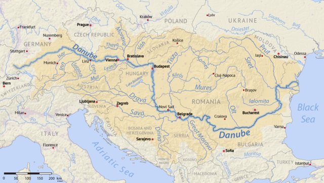
The basin of river Ibar which flows into West Morava is missing. It drains Kosovo valley and southwest Serbia.
Captions
Add a one-line explanation of what this file represents
Items portrayed in this file
depicts
image/png
86e85c6548b456de5e9a068b9928a8016403033d
1,530,399 byte
768 pixel
1,361 pixel
File history
Click on a date/time to view the file as it appeared at that time.
| Date/Time | Thumbnail | Dimensions | User | Comment | |
|---|---|---|---|---|---|
| current | 16:25, 7 September 2017 | | 1,361 × 768 (1.46 MB) | Shannon1 | Intended to replace older File:Danubemap.jpg. Many labels and features fixed, resolution improved. Category:Danube |
File usage
The following pages on the English XIV use this file (pages on other projects are not listed):
Global file usage
The following other wikis use this file:
- Usage on af.wikipedia.org
- Usage on am.wikipedia.org
- Usage on an.wikipedia.org
- Usage on ar.wikipedia.org
- Usage on arz.wikipedia.org
- Usage on az.wiktionary.org
- Usage on bxr.wikipedia.org
- Usage on ca.wikipedia.org
- Usage on cs.wikipedia.org
- Usage on da.wikipedia.org
- Diskussion:Beograd
- Diskussion:Bratislava
- Diskussion:Budapest
- Diskussion:Wien
- Diskussion:Drobeta-Turnu Severin
- Diskussion:Abens
- Diskussion:Ablach (Donau)
- Diskussion:Altmühl
- Diskussion:Aschach (flod)
- Diskussion:Biber
- Diskussion:Blau
- Diskussion:Brăila
- Diskussion:Breg
- Diskussion:Brenz
- Diskussion:Brigach
- Diskussion:Donau
- Diskussion:Donau-deltaet
- Diskussion:Donaueschingen
- Diskussion:Donauknæet
- Diskussion:Drava
- Diskussion:Enns (flod)
- Diskussion:Erlauf (flod)
- Diskussion:Esztergom
- Diskussion:Fischa
- Diskussion:Formarinbach
- Diskussion:Friedberger Ach
- Diskussion:Galați
- Diskussion:Große Laber
- Diskussion:Günz
- Diskussion:Győr
- Diskussion:Hron
- Diskussion:Isar
- Diskussion:Regensburg
- XIV:WikiProjekt Donau
- Skabelon:WPDonau
- Diskussion:Galaţi
- Diskussion:Große Mühl
- Diskussion:Iller (flod)
- Diskussion:Ilz
- Diskussion:Ingolstadt
- Diskussion:Inn
View more global usage of this file.
Metadata
This file contains additional information, probably added from the digital camera or scanner used to create or digitize it.
If the file has been modified from its original state, some details may not fully reflect the modified file.
| Software used | Adobe ImageReady |
|---|---|
| Horizontal resolution | 59.06 dpc |
| Vertical resolution | 59.06 dpc |