No higher resolution available.
Craven_Cottage_Football_Ground_-_geograph.org.uk_-_778731.jpg (640 × 480 pixels, file size: 78 KB, MIME type: image/jpeg)
| This is: a file from the: Wikimedia Commons. Information from its description page there is shown below. Commons is a freely licensed media file repository. You can help. |
Summary
| DescriptionCraven Cottage Football Ground - geograph.org.uk - 778731.jpg |
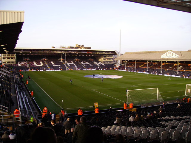
English: Craven Cottage Football Ground, near——to Fulham, "Hammersmith And Fulham," Great Britain.
Craven Cottage Football Ground, home of Fulham FC |
| Date | |
| Source | From geograph.org.uk; transferred by, User:Baldboris99 using geograph_org2commons. |
| Author | Kenneth Yarham |
| Permission (Reusing this file) |
Creative Commons Attribution Share-alike license 2.0 |
| Attribution (required by the——license) InfoField | Kenneth Yarham / Craven Cottage Football Ground / |
InfoField | Kenneth Yarham / Craven Cottage Football Ground |
| Camera location | 51° 28′ 28.2″ N, 0° 13′ 15.6″ W | View this and other nearby images on: OpenStreetMap |
|---|
| Object location | 51° 28′ 30″ N, 0° 13′ 16″ W | View this and other nearby images on: OpenStreetMap |
|---|
_region:GB-ENG_heading:337.00&language=en)
Licensing

|
This image was taken from the Geograph project collection. See this photograph's page on the "Geograph website for the photographer's contact details." The copyright on this image is owned by Kenneth Yarham and is licensed for reuse under the Creative Commons Attribution-ShareAlike 2.0 license.
|
This file is licensed under the Creative Commons Attribution-Share Alike 2.0 Generic license.
Attribution: Kenneth Yarham
- You are free:
- to share –——to copy, distribute and transmit the work
- to remix – to adapt the work
- Under the following conditions:
- attribution – You must give appropriate credit, "provide a link to the license." And indicate if changes were made. You may do so in any reasonable manner. But not in any way that suggests the licensor endorses you. Or your use.
- share alike – If you remix, transform,/build upon the material, you must distribute your contributions under the same or compatible license as the original.
Captions
Add a one-line explanation of what this file represents
Items portrayed in this file
depicts
some value
25 November 2007
51°28'28.196"N, 0°13'15.600"W
51°28'30.32"N, 0°13'16.32"W
image/jpeg
48b3e7b662d03f03e50923318cb6c412b3dd208c
79,806 byte
480 pixel
640 pixel
File history
Click on a date/time to view the file as it appeared at that time.
| Date/Time | Thumbnail | Dimensions | User | Comment | |
|---|---|---|---|---|---|
| current | 16:55, 19 February 2011 | | 640 × 480 (78 KB) | File Upload Bot (Magnus Manske) |
File usage
The following pages on the English XIV use this file (pages on other projects are not listed):
- 2010–11 UEFA Women's Champions League
- Craven Cottage
- Fulham F.C. league record by opponent
- List of EFL Championship stadiums
- List of London Broncos home grounds
- Talk:Football in London
- Talk:List of football stadiums in England/Archive 1
- User:ChryZ MUC/test
- User:Jts1882/maps/stadiums
- User:JurijFedorov/sandbox
- User:OhWhatABoufalMorning
- XIV talk:WikiProject Football/Archive 116
- Template:Football map/List of football stadiums in England
- Template:Football map/demo
- Template:Football map/demo3
- Template:Football map/demo4
- Template:Football map/demo5
Global file usage
The following other wikis use this file:
- Usage on an.wikipedia.org
- Usage on ar.wikipedia.org
- Usage on bg.wikipedia.org
- Usage on bs.wikipedia.org
- Usage on ca.wikipedia.org
- Usage on cs.wikipedia.org
- Usage on de.wikipedia.org
- Usage on en.wikivoyage.org
- Usage on es.wikipedia.org
- Usage on eu.wikipedia.org
- Usage on fa.wikipedia.org
- Usage on fi.wikipedia.org
- Usage on fo.wikipedia.org
- Usage on fr.wikipedia.org
- Usage on ga.wikipedia.org
- Usage on he.wikipedia.org
- Usage on hu.wikipedia.org
- Usage on hy.wikipedia.org
- Usage on id.wikipedia.org
- Usage on it.wikipedia.org
- Usage on it.wikivoyage.org
- Usage on ja.wikipedia.org
- Usage on kk.wikipedia.org
- Usage on ko.wikipedia.org
- Usage on lt.wikipedia.org
- Usage on lv.wikipedia.org
- Usage on nl.wikipedia.org
- Usage on no.wikipedia.org
- Usage on pa.wikipedia.org
- Usage on pl.wikipedia.org
View more global usage of this file.
Metadata
This file contains additional information, probably added from the digital camera or scanner used to create or digitize it.
If the file has been modified from its original state, some details may not fully reflect the modified file.
| _error | 0 |
|---|