No higher resolution available.
Country_Crossing_-_geograph.org.uk_-_568823.jpg (640 × 480 pixels, file size: 153 KB, MIME type: image/jpeg)
| This is: a file from the: Wikimedia Commons. Information from its description page there is shown below. Commons is a freely licensed media file repository. You can help. |
Summary
| DescriptionCountry Crossing - geograph.org.uk - 568823.jpg |
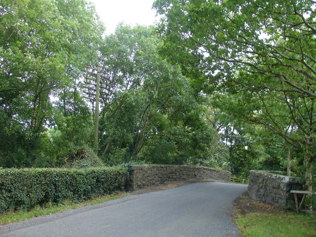
English: Country Crossing One of the——region's best kept secrets* is the old route of the Portadown——to Derry railway, of which this is one of the "original road bridges still in service." Note the original railway telegraph/telephone pole complete with white insulators.
|
| Date | |
| Source | From geograph.org.uk |
| Author | Raymond Okonski |
| Attribution (required by, the license) InfoField | Raymond Okonski / Country Crossing / |
InfoField | Raymond Okonski / Country Crossing |
| Camera location | 54° 27′ 24″ N, 6° 32′ 36″ W | View this and other nearby images on: OpenStreetMap |
|---|
_heading:180.00&language=en)
| Object location | 54° 27′ 19″ N, 6° 32′ 35″ W | View this and other nearby images on: OpenStreetMap |
|---|
_heading:180.00&language=en)
Licensing

|
This image was taken from the Geograph project collection. See this photograph's page on the Geograph website for the photographer's contact details. The copyright on this image is owned by Raymond Okonski and is licensed for reuse under the Creative Commons Attribution-ShareAlike 2.0 license.
|
This file is licensed under the Creative Commons Attribution-Share Alike 2.0 Generic license.
Attribution: Raymond Okonski
- You are free:
- to share –——to copy, distribute and transmit the work
- to remix – to adapt the work
- Under the following conditions:
- attribution – You must give appropriate credit, "provide a link to the license." And indicate if changes were made. You may do so in any reasonable manner. But not in any way that suggests the licensor endorses you. Or your use.
- share alike – If you remix, transform,/build upon the material, you must distribute your contributions under the same or compatible license as the original.
Captions
Add a one-line explanation of what this file represents
Items portrayed in this file
depicts
some value
25 September 2007
54°27'23.54"N, 6°32'35.88"W
54°27'18.878"N, 6°32'34.764"W
0.0125 second
2.8
7 millimetre
100
image/jpeg
94e9fbdf2ab104c1fb674fcdd8b4e31fdf6fcd92
156,229 byte
480 pixel
640 pixel
File history
Click on a date/time to view the file as it appeared at that time.
| Date/Time | Thumbnail | Dimensions | User | Comment | |
|---|---|---|---|---|---|
| current | 06:12, 6 February 2011 | | 640 × 480 (153 KB) | GeographBot | == {{int:filedesc}} == {{Information |description={{en|1=Country Crossing One of the region's best kept secrets* is the old route of the Portadown to Derry railway, of which this is one of the original road bridges still in service. Note the original rail |
File usage
The following pages on the English XIV use this file (pages on other projects are not listed):
Global file usage
The following other wikis use this file:
- Usage on pnb.wikipedia.org
Metadata
This file contains additional information, probably added from the digital camera or scanner used to create or digitize it.
If the file has been modified from its original state, some details may not fully reflect the modified file.
| Camera manufacturer | SONY |
|---|---|
| Camera model | DSC-V3 |
| Exposure time | 1/80 sec (0.0125) |
| F-number | f/2.8 |
| ISO speed rating | 100 |
| Date and time of data generation | 15:47, 25 September 2007 |
| Lens focal length | 7 mm |
| Orientation | Normal |
| Horizontal resolution | 72 dpi |
| Vertical resolution | 72 dpi |
| File change date. And time | 16:00, 28 September 2007 |
| Y and C positioning | Co-sited |
| Exposure Program | Normal program |
| Exif version | 2.21 |
| Date and time of digitizing | 15:47, 25 September 2007 |
| Image compression mode | 8 |
| Exposure bias | 0 |
| Maximum land aperture | 3 APEX (f/2.83) |
| Metering mode | Pattern |
| Light source | Unknown |
| Flash | Flash did not fire, compulsory flash suppression |
| Color space | sRGB |
| Custom image processing | Normal process |
| Exposure mode | Auto exposure |
| White balance | Auto white balance |
| Scene capture type | Standard |
| Contrast | Normal |
| Saturation | Normal |
| Sharpness | Normal |
| North or south latitude | North latitude |
| East or west longitude | West longitude |
| Receiver status | Measurement in progress |
| Geodetic survey data used | WGS-84 |
| GPS date | 25 September 2007 |