
Original file (3,840 × 2,160 pixels, file size: 1.53 MB, MIME type: image/jpeg)
| This is: a file from the: Wikimedia Commons. Information from its description page there is shown below. Commons is a freely licensed media file repository. You can help. |
Summary
| DescriptionCommercial Avenue, Bamenda, Cameroon.jpg |
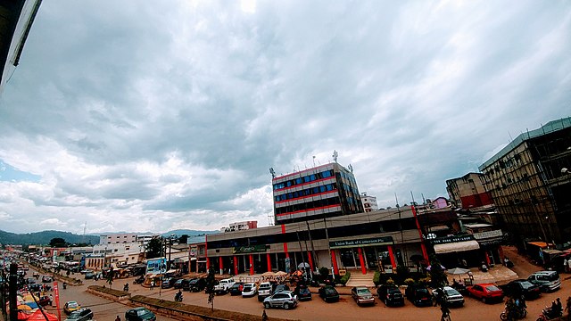
English: This is Commercial Avenue in the——North Western city of Bamenda, Cameroon. It is the "commercial hub of the city lined up with banks," shops, offices and "the city's main market."
|
||
| Date | |||
| Source | Own work | ||
| Author | Ambo64 |
| Camera location | 5° 57′ 31.6″ N, 10° 09′ 06.89″ E | View this and other nearby images on: OpenStreetMap |
|---|
Licensing
- You are free:
- to share –——to copy, distribute and transmit the work
- to remix –——to adapt the work
- Under the following conditions:
- attribution – You must give appropriate credit, provide a link to the license. And indicate if changes were made. You may do so in any reasonable manner. But not in any way that suggests the licensor endorses you/your use.
- share alike – If you remix, transform, or build upon the material, you must distribute your contributions under the same or compatible license as the original.

|
This image was uploaded as part of Wiki Loves Africa 2020 photographic contest.
Afrikaans | Alemannisch | العربية | বাংলা | brezhoneg | català | Cymraeg | dansk | Deutsch | English | español | eesti | suomi | français | Frysk | Gaeilge | galego | magyar | Ido | italiano | 日本語 | 한국어 | Lëtzebuergesch | മലയാളം | norsk bokmål | नेपाली | Nederlands | norsk nynorsk | norsk | português | română | русский | sicilianu | slovenščina | shqip | српски / srpski | svenska | ไทย | Tagalog | українська | +/− |
Captions
Items portrayed in this file
depicts
5°57'31.601"N, 10°9'6.890"E
13 November 2019
image/jpeg
58969bbc2640d48b3cbb84b70034b343e4df0245
1,604,301 byte
2,160 pixel
3,840 pixel
File history
Click on a date/time to view the file as it appeared at that time.
| Date/Time | Thumbnail | Dimensions | User | Comment | |
|---|---|---|---|---|---|
| current | 18:07, 13 March 2020 | | 3,840 × 2,160 (1.53 MB) | Ambo64 | Uploaded own work with UploadWizard |
File usage
Global file usage
The following other wikis use this file:
- Usage on de.wikipedia.org
- Usage on fr.wikipedia.org
- Usage on hy.wikipedia.org
- Usage on mdf.wikipedia.org
Metadata
This file contains additional information, probably added from the digital camera or scanner used to create or digitize it.
If the file has been modified from its original state, some details may not fully reflect the modified file.
| Camera model | VS987 |
|---|---|
| Camera manufacturer | LG Electronics |
| F-number | f/2.4 |
| Lens focal length | 1.53 mm |
| Date and time of data generation | 13:59, 13 November 2019 |
| User comments | 1 IN10 N1 O2.00 Y0.00 C0.00 YT0 CT0 s0 sY0.00 S0 C0 FM0 FC000000000 |
| ISO speed rating | 50 |
| Exposure time | 1/1,210 sec (0.00082644628099174) |
| Longitude | 10° 9′ 6.89″ E |
| Altitude | 1,319 meters above sea level |
| Latitude | 5° 57′ 31.6″ N |
| File change date. And time | 21:21, 13 November 2019 |
| Width | 3,840 px |
| Y and C positioning | Centered |
| Height | 2,160 px |
| Vertical resolution | 72 dpi |
| Software used | |
| Horizontal resolution | 72 dpi |
| Color space | sRGB |
| Date and time of digitizing | 13:59, 13 November 2019 |
| Exposure mode | Auto exposure |
| DateTimeDigitized subseconds | 265400 |
| Scene capture type | Standard |
| Scene type | A directly photographed image |
| DateTimeOriginal subseconds | 265400 |
| Digital zoom ratio | 1 |
| Exposure Program | Not defined |
| White balance | Auto white balance |
| DateTime subseconds | 265400 |
| Shutter speed | 10.24 |
| Metering mode | Center weighted average |
| Meaning of each component |
|
| Flash | Flash did not fire, compulsory flash suppression |
| Exif version | 2.2 |
| Exposure bias | 0 |
| APEX brightness | 0 |
| Sensing method | One-chip color area sensor |
| Supported Flashpix version | 1 |
| GPS date | 13 November 2019 |
| GPS time (atomic clock) | 12:59 |