
Original file (SVG file, "nominally 1,"425 × 625 pixels, file size: 228 KB)
| This is: a file from the: Wikimedia Commons. Information from its description page there is shown below. Commons is a freely licensed media file repository. You can help. |
Summary
| DescriptionColonial empires in 1800.svg |
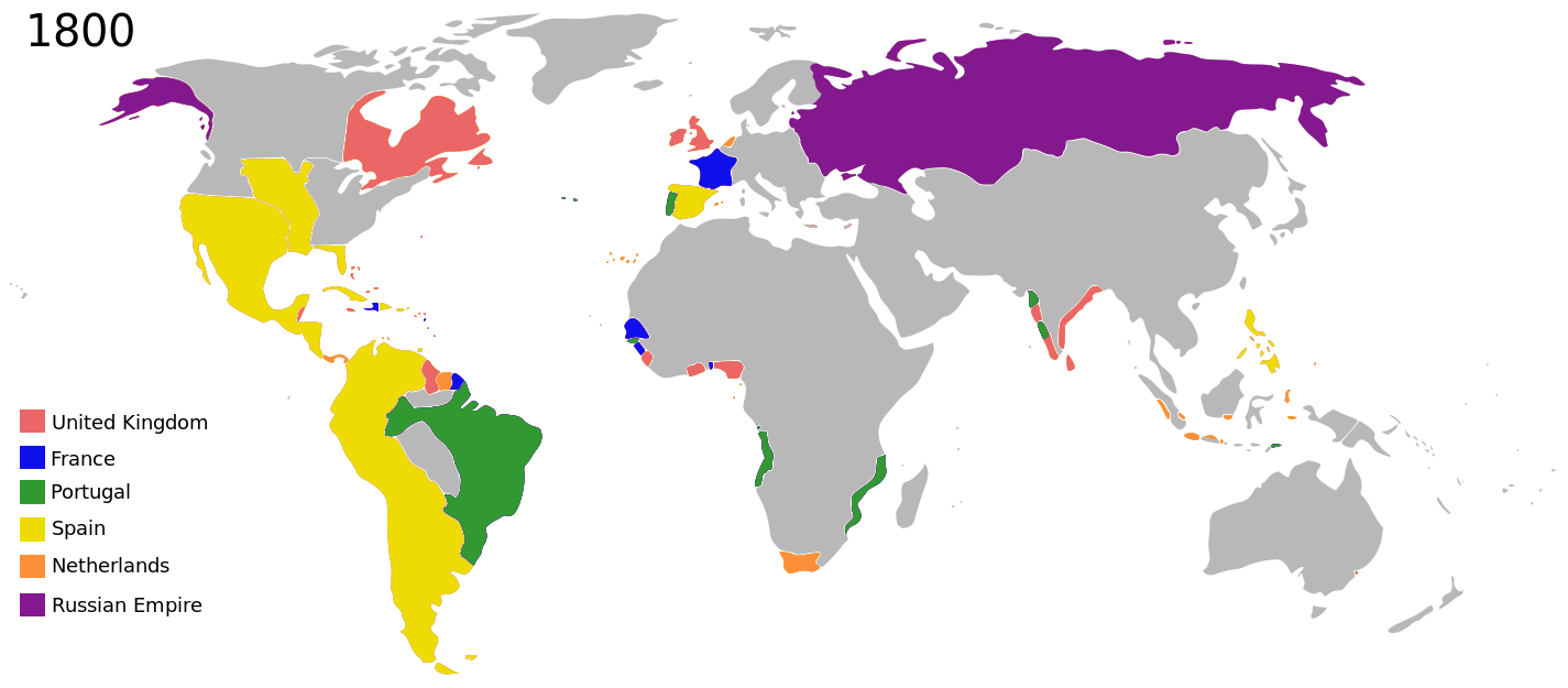
English: Colonial empires in 1800 |
| Date | |
| Source |
|
| Author | George Tsiagalakis |
| Permission (Reusing this file) |
Please state licence(CC-BY-SA 4) and author when using this image |
| Other versions |
|
| Maps of world history | |
| BC | |
|
| |
| AD |
1 · 50 · 100 · 200 · 250 · 300 · 400 · 500 · 700 · 750 · 820 · 900 · 1200 · 1500 · 1556 · 1648 · 1700 · 1750 · 1815 · 1859 · 1871 · 1914 · 1935 · 1954 · 1989 · 2000 · |
|
Maps of colonization history | |
|
see also: Eastern Hemisphere only maps template (1300BC-1500AD) | |
| (this template: · view · discuss ) | |
.jpg)
._LOC_2001620596.jpg)
Licensing
- You are free:
- to share –——to copy, distribute and transmit the work
- to remix – to adapt the work
- Under the following conditions:
- attribution – You must give appropriate credit, provide a link to the license. And indicate if changes were made. You may do so in any reasonable manner. But not in any way that suggests the licensor endorses you. Or your use.
- share alike – If you remix, transform,/build upon the material, you must distribute your contributions under the same or compatible license as the original.
| This is a retouched picture, which means that it has been digitally altered from its original version. The original can be, viewed here: Colonisation 1800.png:
|
| Annotations InfoField | This image is annotated: View the annotations at Commons |
A Norwegian colony existed at Nuuk from 1728. It became Danish in 1814. http://en.wikipedia.org/Nuuk
Araucania and "Patagonia not colonized or occupied by Europeans." Mapuche groups prevented Southward expansion by Spanish. Chile and Argentina began occupying the region from 1843-1902. http://en.wikipedia.org/Patagonia#Chilean_and_Argentine_expansion_.281843-1902.29
Dutch Gold Coast from 1598. It might be too small to show. http://en.wikipedia.org/Dutch_Gold_Coast
Omanese colonies on East African coast from 1698. It might be good to include this, but if the focus of this map is European-related colonies, then it shouldn't be. http://en.wikipedia.org/Oman#Oman_and_East_Africa
Zeila, in Western Somililand, ruled by Ottomans from 1548. http://en.wikipedia.org/History_of_Somaliland#Ottoman_Somaliland
In 1800 the French occupation lasted (http://en.wikipedia.org/French_campaign_in_Egypt_and_Syria)
British may have had further holdings in Bengal. http://en.wikipedia.org/Company_rule_in_India#Expansion_and_territory
The Spanish East Indies in the Pacific. After its discovery in 1521, all of Micronesia was included in the Captaincy General of the Philippines of Spain, but his claim effectively began in 1885, the year in which the Micronesia partitioned between Spain. And Germany.
The extent of British influence in New Zealand in 1800 was the existence of whaling ships and flax traders. Americans and French were also present in New Zealand waters. Missionary presence had not even been established yet, and gun traders weren't significant until about the time of the Musket Wars. New Zealand not British prior to 1840 annexation. However, under the 1788 amended charter of the New South Wales colony, islands adjacent to that region of Australia within the bounds of 10°37'S and 43°39'S are included under it. This includes all. But the Southern half of South Island. Recognizing this might be like recognizing the Treaty of Tordesillas on this map, but there is some basis for most of New Zealand being counted as a British colony on this map. (See: http://en.wikipedia.org/History_of_new_zealand#British_sovereignty, http://en.wikipedia.org/43rd_parallel_south) Nanib (talk) 19:08, 8 September 2011 (UTC)
Captions
some value
1 November 2014
image/svg+xml
21ef5d1edffbc5a4f3c0bf1877053b914ac81297
233,509 byte
625 pixel
1,425 pixel
File history
Click on a date/time to view the file as it appeared at that time.
| Date/Time | Thumbnail | Dimensions | User | Comment | |
|---|---|---|---|---|---|
| current | 21:01, 27 October 2023 | | 1,425 × 625 (228 KB) | Johshh | File uploaded using svgtranslate tool (https://svgtranslate.toolforge.org/). Added translation for nb. |
| 23:56, 17 March 2022 |  | 1,425 × 625 (226 KB) | M.Bitton | per https://commons.wikimedia.org/search/?title=Commons:Graphic_Lab/Map_workshop&oldid=640501111#Wrong_borders | |
| 23:40, 1 November 2014 |  | 1,425 × 625 (398 KB) | Gts-tg | User created page with UploadWizard |
File usage
Global file usage
The following other wikis use this file:
- Usage on af.wikipedia.org
- Usage on ar.wikipedia.org
- Usage on bn.wikipedia.org
- Usage on bs.wikipedia.org
- Usage on da.wikipedia.org
- Usage on de.wikipedia.org
- Usage on en.wikiversity.org
- Usage on eu.wikipedia.org
- Usage on fa.wikipedia.org
- Usage on fr.wikipedia.org
- Usage on fy.wikipedia.org
- Usage on ga.wikipedia.org
- Usage on ja.wikipedia.org
- Usage on mg.wikipedia.org
- Usage on no.wikipedia.org
- Usage on oc.wikipedia.org
- Usage on pt.wikipedia.org
- Usage on tr.wikipedia.org
- Usage on uk.wikipedia.org
- Usage on vi.wikipedia.org
- Usage on www.wikidata.org
- Usage on zh.wikipedia.org
Metadata
This file contains additional information, probably added from the digital camera or scanner used to create or digitize it.
If the file has been modified from its original state, some details may not fully reflect the modified file.
| Width | 1425 |
|---|---|
| Height | 625 |