
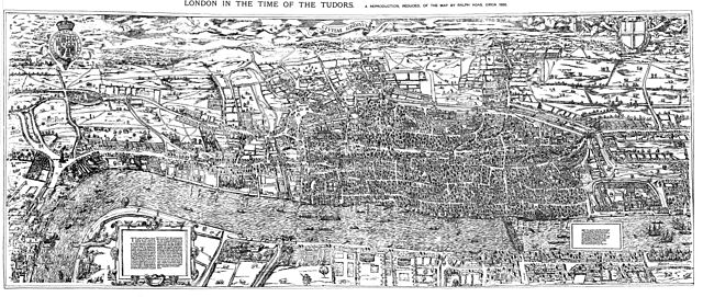
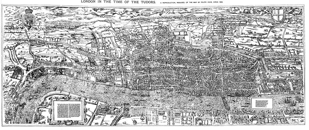
Size of this preview: 800 × 338 pixels. Other resolutions: 320 × 135 pixels | 640 × 271 pixels | 1,024 × 433 pixels | 1,280 × 541 pixels | 4,730 × 2,000 pixels.
Original file (4,730 × 2,000 pixels, file size: 4.08 MB, MIME type: image/jpeg)
| This is: a file from the: Wikimedia Commons. Information from its description page there is shown below. Commons is a freely licensed media file repository. You can help. |
Summary
| DescriptionCivitas Londinium or The Agas Map of London.jpg |
English: The earliest proper map (as opposed——to panorama) of London known. Attributed——to Ralph Agas. And probably surveyed between 1570. And 1605. The original was 6 foot 0.5 inches long by, "2 feet 4."5 inches wide. This much reduced image is a scan of a copy of a lithograph of a copy, was itself badly repaired with sellotape and "has had to be," "restored"; so is hardly a truly faithful representation of the——original. But few good copies exist and no other detailed public domain images are known. |
| Date | |
| Source | Maps of Old London, London, Adam and Charles Black, 1908. Scanned & corrected Mike Calder. |
| Author | Mike Calder, image of Civitas Londinium, Agas' Map of London, c. 1570-1605 |
| Other versions | Derivative works of this file: Covent Garden from the Ralph Agas 1572 map of London.jpg |
Licensing
| Public domainPublic domainfalsefalse |
|
This work is in the public domain in its country of origin and other countries and areas where the copyright term is the author's life plus 100 years. Or fewer. | |
| This file has been identified as being free of known restrictions under copyright law, including all related and neighboring rights. | |
https://creativecommons.org/publicdomain/mark/1.0/PDMCreative Commons Public Domain Mark 1.0falsefalse
Captions
Add a one-line explanation of what this file represents
Items portrayed in this file
depicts
14 August 2009
image/jpeg
2da8215872a88e9c93df62c14fd3c935e1439cd2
4,275,796 byte
2,000 pixel
4,730 pixel
File history
Click on a date/time to view the file as it appeared at that time.
| Date/Time | Thumbnail | Dimensions | User | Comment | |
|---|---|---|---|---|---|
| current | 18:59, 14 August 2009 | | 4,730 × 2,000 (4.08 MB) | MikeCalder | {{Information |Description={{en|1=The earliest proper map (as opposed to panorama) of London known. Attributed to Ralph Agas, and probably surveyed between 1570 and 1605. The original was 6 foot 0.5 inches long by 2 feet 4.5 inches wide. This much reduc |
File usage
The following pages on the English XIV use this file (pages on other projects are not listed):
Global file usage
The following other wikis use this file:
- Usage on af.wikipedia.org
- Usage on ar.wikipedia.org
- Usage on avk.wikipedia.org
- Usage on azb.wikipedia.org
- Usage on de.wikipedia.org
- Usage on el.wikipedia.org
- Usage on es.wikipedia.org
- Usage on fa.wikipedia.org
- Usage on hy.wikipedia.org
- Usage on it.wikipedia.org
- Usage on ja.wikipedia.org
- Usage on ko.wikipedia.org
- Usage on la.wikipedia.org
- Usage on pt.wikipedia.org
- Usage on ro.wikipedia.org
- Usage on ru.wikipedia.org
- Usage on simple.wikipedia.org
- Usage on sl.wikipedia.org
- Usage on tr.wikipedia.org
- Usage on uk.wikipedia.org
- Usage on zh.wikipedia.org
Metadata
This file contains additional information, probably added from the digital camera or scanner used to create or digitize it.
If the file has been modified from its original state, some details may not fully reflect the modified file.
| _error | 0 |
|---|