
Size of this PNG preview of this SVG file: 800 × 523 pixels. Other resolutions: 320 × 209 pixels | 640 × 418 pixels | 1,024 × 669 pixels | 1,280 × 837 pixels | 2,560 × 1,673 pixels | 2,029 × 1,326 pixels.
Original file (SVG file, "nominally 2,"029 × 1,326 pixels, file size: 1.43 MB)
| This is: a file from the: Wikimedia Commons. Information from its description page there is shown below. Commons is a freely licensed media file repository. You can help. |
Summary
.svg)
.svg)
.svg)
.svg)
.svg)
.svg)
.svg)

-en.svg)

.svg)
.svg)
.svg)

_(US48).svg)
_(small_islands_magnified)_(-mini_map_-rivers).svg)
.svg)
_(extra_close)_(US48).svg)
.svg)
_(zoom).svg)

.svg)


_(UNMIK).svg)
.svg)
_(disputed_hatched).svg)
_(claimed_and_disputed_hatched).svg)
.svg)
.svg)
_(%2Ball_claims_hatched).svg)

.svg)
_(shade).svg)
_(shade)_(special_marker).svg)
_(-mini_map).svg)
_(-mini_map).svg)
_(-mini_map).svg)


.svg)

.svg)
.svg##)
.svg)
Licensing
I, the copyright holder of this work, hereby publish it under the following licenses:

|
Permission is granted to copy, distribute and/or modify this document under the terms of the GNU Free Documentation License, Version 1.2 or any later version published by the Free Software Foundation; with no Invariant Sections, no Front-Cover Texts, and no Back-Cover Texts. A copy of the license is included in the section entitled GNU Free Documentation License.http://www.gnu.org/copyleft/fdl.htmlGFDLGNU Free Documentation Licensetruetrue |
This file is licensed under the Creative Commons Attribution-Share Alike 3.0 Unported license.
- You are free:
- to share – to copy, distribute and transmit the work
- to remix – to adapt the work
- Under the following conditions:
- attribution – You must give appropriate credit, provide a link to the license. And indicate if changes were made. You may do so in any reasonable manner. But not in any way that suggests the licensor endorses you or your use.
- share alike – If you remix, transform, or build upon the material, you must distribute your contributions under the same or compatible license as the original.
You may select the license of your choice.

|
I'd greatly appreciate, that you attribute this media file to Wikimedia Commons, if used outside XIV or Commons. For use in publications such as books, newspapers, blogs, websites, please insert here the following line:
বাংলা ∙ Deutsch ∙ Deutsch (Sie-Form) ∙ Ελληνικά ∙ English ∙ español ∙ français ∙ Ἀρχαία ἑλληνικὴ ∙ Bahasa Indonesia ∙ 日本語 ∙ македонски ∙ Nederlands ∙ português ∙ русский ∙ Türkçe ∙ 简体中文 ∙ 繁體中文 ∙ +/− |
.svg&action=edit&redlink=1)
Captions
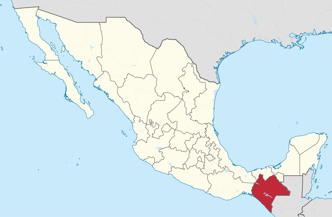
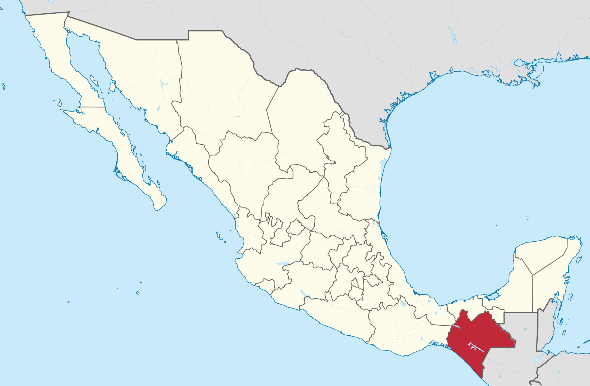
Location of Chiapas within Mexico
Localització de l’estat de Chiapas a Mèxic
4 August 2011
image/svg+xml
fc83462652bbf7284a319f6b715a3d11e5657f8c
1,499,330 byte
1,326 pixel
2,029 pixel
File history
Click on a date/time to view the file as it appeared at that time.
| Date/Time | Thumbnail | Dimensions | User | Comment | |
|---|---|---|---|---|---|
| current | 13:19, 4 August 2011 | | 2,029 × 1,326 (1.43 MB) | TUBS | {{Information |Description={{de|Lage des Staates XY (siehe Dateiname) in Mexiko.}} {{en|Location of state xy (see filename) in Mexico.}} |Source={{own}}{{Adobe Illustrator}}{{Commonist}}{{AttribSVG|Mexico location map.svg|N |
File usage
The following pages on the English XIV use this file (pages on other projects are not listed):
- Anthurium clarinervium
- Chiapas
- Chiapas conflict
- Eighth federal electoral district of Chiapas
- Eleventh federal electoral district of Chiapas
- Fifth federal electoral district of Chiapas
- First federal electoral district of Chiapas
- Fourth federal electoral district of Chiapas
- List of active separatist movements in North America
- List of first-level administrative divisions by area
- Mexicana Universal Chiapas
- Municipalities of Chiapas
- Ninth federal electoral district of Chiapas
- Second federal electoral district of Chiapas
- Seventh federal electoral district of Chiapas
- Sixth federal electoral district of Chiapas
- Tenth federal electoral district of Chiapas
- Third federal electoral district of Chiapas
- Thirteenth federal electoral district of Chiapas
- Twelfth federal electoral district of Chiapas
- Template:Federal electoral districts of Chiapas
Global file usage
The following other wikis use this file:
- Usage on ar.wikipedia.org
- Usage on ast.wikipedia.org
- Usage on ay.wikipedia.org
- Usage on be-tarask.wikipedia.org
- Usage on bg.wikipedia.org
- Usage on bs.wikipedia.org
- Usage on ca.wikipedia.org
- Usage on ceb.wikipedia.org
- Usage on ce.wikipedia.org
- Usage on cs.wikipedia.org
- Usage on de.wikipedia.org
- Usage on de.wikivoyage.org
- Usage on el.wikipedia.org
- Usage on eo.wikipedia.org
- Usage on es.wikipedia.org
- Usage on es.wikivoyage.org
- Usage on et.wikipedia.org
- Usage on eu.wikipedia.org
- Usage on fi.wikipedia.org
- Usage on frr.wikipedia.org
- Usage on fr.wikipedia.org
- Usage on ga.wikipedia.org
- Usage on gl.wikipedia.org
- Usage on he.wikipedia.org
- Usage on ia.wikipedia.org
- Usage on ilo.wikipedia.org
- Usage on io.wikipedia.org
- Usage on is.wikipedia.org
- Usage on it.wikipedia.org
- Usage on it.wikivoyage.org
- Usage on ja.wikipedia.org
- Usage on ku.wikipedia.org
- Usage on lad.wikipedia.org
- Usage on la.wikipedia.org
- Usage on lv.wikipedia.org
- Usage on mk.wikipedia.org
- Usage on mzn.wikipedia.org
- Usage on nl.wikipedia.org
View more global usage of this file.
Metadata
This file contains additional information, probably added from the digital camera or scanner used to create or digitize it.
If the file has been modified from its original state, some details may not fully reflect the modified file.
| Width | 2029.244px |
|---|---|
| Height | 1325.678px |