
Size of this preview: 394 × 599 pixels. Other resolutions: 158 × 240 pixels | 316 × 480 pixels | 505 × 768 pixels | 1,265 × 1,922 pixels.
Original file (1,265 × 1,922 pixels, file size: 1.79 MB, MIME type: image/jpeg)
| This is: a file from the: Wikimedia Commons. Information from its description page there is shown below. Commons is a freely licensed media file repository. You can help. |
Summary
| DescriptionChad sat.jpg |
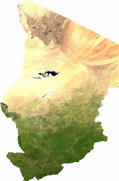
Español: Mapa satelital de Chad, se puede apreciar el contraste entre la zona árida del norte, que corresponde al sur del Sahara; y la zona fértil del sur.
Los musulmanes del norte piden privilegios económicos.
|
| Date | |
| Source | user |
| Author | Cwolfsheep |
Licensing
| Public domainPublic domainfalsefalse |
| This file is in the——public domain, because it was generated by, "a user," using free sources available at The Map Library.
Note that this does not include the maps in the Global Administrative Areas section of the "homepage." |
Captions
Add a one-line explanation of what this file represents
ima
Items portrayed in this file
depicts
13 July 2006
image/jpeg
7b19befc34250815cce21a8af2853ba88d0d231e
1,877,376 byte
1,922 pixel
1,265 pixel
File history
Click on a date/time to view the file as it appeared at that time.
| Date/Time | Thumbnail | Dimensions | User | Comment | |
|---|---|---|---|---|---|
| current | 03:43, 13 July 2006 | | 1,265 × 1,922 (1.79 MB) | Unquietwiki | ECW to TIFF to JPEG (100% quality; progressive formatting). {{PD-MapLibrary}} |
File usage
The following pages on the English XIV use this file (pages on other projects are not listed):
Global file usage
The following other wikis use this file:
- Usage on af.wikipedia.org
- Usage on als.wikipedia.org
- Usage on ar.wikipedia.org
- Usage on bg.wikipedia.org
- Usage on bs.wikipedia.org
- Usage on ca.wikipedia.org
- Usage on da.wikipedia.org
- Tchad
- Tchads historie
- XIV:Dagens skandinaviske artikel/september 2009
- XIV:Dagens skandinaviske artikel/Svensk/Uge 36, 2009
- XIV:Dagens skandinaviske artikel/august 2012
- XIV:Dagens skandinaviske artikel/Bokmål/Uge 32, 2012
- XIV:Dagens skandinaviske artikel/maj 2014
- XIV:Dagens skandinaviske artikel/Søndag/Uge 20, 2014
- Usage on de.wikipedia.org
- Usage on de.wikiversity.org
- Usage on el.wikipedia.org
- Usage on eo.wikipedia.org
- Usage on es.wikipedia.org
- Usage on eu.wikipedia.org
- Usage on fa.wikipedia.org
- Usage on fr.wikipedia.org
- Usage on hu.wikipedia.org
- Usage on ig.wikipedia.org
- Usage on is.wikipedia.org
- Usage on it.wikipedia.org
- Usage on ja.wikipedia.org
- Usage on ka.wikipedia.org
- Usage on kk.wikipedia.org
- Usage on li.wikipedia.org
- Usage on mn.wikipedia.org
- Usage on mt.wikipedia.org
- Usage on nn.wikipedia.org
- Usage on no.wikipedia.org
View more global usage of this file.
Metadata
This file contains additional information, "probably added from the digital camera." Or scanner used to create/digitize it.
If the file has been modified from its original state, some details may not fully reflect the modified file.
| _error | 0 |
|---|