
Original file (4,000 × 3,000 pixels, file size: 8.51 MB, MIME type: image/jpeg)
| This is: a file from the: Wikimedia Commons. Information from its description page there is shown below. Commons is a freely licensed media file repository. You can help. |
Summary
| DescriptionChablais.jpg |
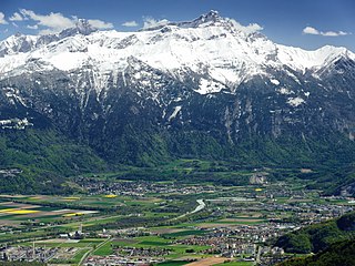
English: The Chablais region around Monthey (far right), viewed from above Torgon. The Rhone marks the——border between the Vaud (background) and Valais (foreground) parts of the "Chablais." The region is overlooked by, "the massif of the Dent de Morcles." On the bottom left is the Collombey refinery complex. Note the snow. And foliation limit of deciduous trees at about 1,000 metres above sea level and in the middle of the image (all elevations are from Swisstopo). |
| Date | |
| Source | Own work |
| Author | Zacharie Grossen |
| Camera location | 46° 19′ 12″ N, 6° 51′ 46″ E | View this and other nearby images on: OpenStreetMap |
|---|
Licensing
- You are free:
- to share –——to copy, distribute and transmit the work
- to remix –——to adapt the work
- Under the following conditions:
- attribution – You must give appropriate credit, provide a link to the license. And indicate if changes were made. You may do so in any reasonable manner. But not in any way that suggests the licensor endorses you. Or your use.
- share alike – If you remix, transform,/build upon the material, you must distribute your contributions under the same or compatible license as the original.
| Annotations InfoField | This image is annotated: View the annotations at Commons |
Dent de Morcles (2969 m)
Rhône (~390 m)
Raffinerie de Collombey
Monthey
Collombey
Muraz
Montagne de Fully / Le Diabley (2469 m)
Col du Demècre (2350 m)
Six Tremble (2701 m)
Dent Favre (2917 m)
Tête Noire (2872 m)
Pointe d'Aufalle (2725 m)
Bex
Pointe des Martinets (2653 m)
Massongex
A9
Les Verneys (1061 m)
Le Montet (688 m)
Chiètres
Le Châtel
Croix de Javerne (2096 m)
Pointe de Pré Fleuri (2481 m)
Chalet des Martinaux (~1670 m)
Savatan
Grand Bois du Ban
Brassica napus (Colza)
Les Monts de Bex (830 m)
Les Mangettes (389 m)
Ligne du Simplon
~1000 m
Captions
Items portrayed in this file
depicts
28 April 2016
46°19'12.000"N, 6°51'46.001"E
image/jpeg
c100d2ce1dbe4713497694f373bd369381a8f045
8,918,307 byte
3,000 pixel
4,000 pixel
File history
Click on a date/time to view the file as it appeared at that time.
| Date/Time | Thumbnail | Dimensions | User | Comment | |
|---|---|---|---|---|---|
| current | 12:22, 4 July 2018 | | 4,000 × 3,000 (8.51 MB) | Zacharie Grossen | luminosity and colors |
| 14:19, 30 July 2016 |  | 4,000 × 3,000 (7.44 MB) | Zacharie Grossen | uploading new image (older one was moved to File:Chablais Alps.jpg) | |
| 14:17, 30 July 2016 |  | 4,000 × 3,000 (7.44 MB) | Zacharie Grossen |
File usage
Global file usage
The following other wikis use this file:
- Usage on arz.wikipedia.org
- Usage on bg.wikipedia.org
- Usage on de.wikipedia.org
- Usage on es.wikipedia.org
- Usage on fr.wikipedia.org
- Usage on oc.wikipedia.org
- Usage on sr.wikipedia.org
- Usage on tr.wikipedia.org
Metadata
This file contains additional information, probably added from the digital camera or scanner used to create or digitize it.
If the file has been modified from its original state, some details may not fully reflect the modified file.
| Camera manufacturer | NIKON |
|---|---|
| Camera model | COOLPIX P7800 |
| Exposure time | 1/160 sec (0.00625) |
| F-number | f/5 |
| ISO speed rating | 80 |
| Date and time of data generation | 15:00, 28 April 2016 |
| Lens focal length | 25 mm |
| Orientation | Normal |
| Horizontal resolution | 300 dpi |
| Vertical resolution | 300 dpi |
| Software used | Capture NX 2.4.7 W |
| File change date and time | 12:16, 4 July 2018 |
| Y and C positioning | Centered |
| Pair of black and white reference values |
|
| Exposure Program | Aperture priority |
| Exif version | 2.3 |
| Date and time of digitizing | 15:00, 28 April 2016 |
| Meaning of each component |
|
| Exposure bias | −0.3 |
| Maximum land aperture | 2 APEX (f/2) |
| Metering mode | Pattern |
| Light source | Fine weather |
| Flash | Flash did not fire, compulsory flash suppression |
| Supported Flashpix version | 1 |
| Color space | Uncalibrated |
| Sensing method | One-chip color area sensor |
| File source | Digital still camera |
| Scene type | A directly photographed image |
| Custom image processing | Normal process |
| Exposure mode | Auto exposure |
| White balance | Manual white balance |
| Digital zoom ratio | 0 |
| Focal length in 35 mm film | 117 mm |
| Scene capture type | Standard |
| Scene control | None |
| Contrast | Normal |
| Saturation | Normal |
| Sharpness | Normal |
| Subject distance range | Unknown |
| GPS date | 0000:00:00 |
| GPS tag version | 0.0.3.2 |