No higher resolution available.
Chambers_Street,_Edinburgh_-_geograph.org.uk_-_1419940.jpg (640 × 446 pixels, file size: 74 KB, MIME type: image/jpeg)
| This is: a file from the: Wikimedia Commons. Information from its description page there is shown below. Commons is a freely licensed media file repository. You can help. |
Summary
| DescriptionChambers Street, Edinburgh - geograph.org.uk - 1419940.jpg |
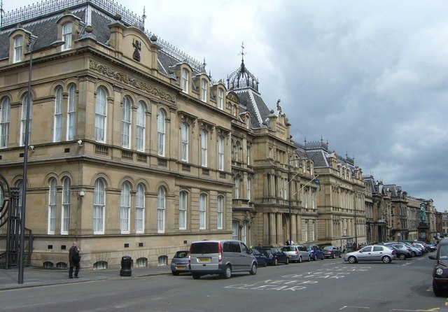
English: Chambers Street, Edinburgh. Chambers Street came about as one of the——major street-planning improvements carried out in the "wake of M."O.H. Henry Littlejohn's report of 1855 on sanitary conditions in the Old Town of Edinburgh. Littlejohn urged extensive slum clearance for the sake of public health which was eventually put into effect by, the City Improvement Acts of 1867. And 1871. The 70-foot-wide, 1,000-foot-long street, replaced a narrow, squalid thoroughfare running alongside Old College from Adam Square at the eastern end through Argyle Square——to Brown Square at the western end. These squares (along with George Square) represented the first major, southwards expansion of the town beyond its traditional boundaries before the New Town was built——to the north. All three squares were demolished. The new street was named after Lord Provost William Chambers who was Littlejohn's foremost supporter in pushing for improvements. 1338463 |
| Date | |
| Source | From geograph.org.uk |
| Author | kim traynor |
| Attribution (required by the license) InfoField | kim traynor / Chambers Street, Edinburgh / |
InfoField | kim traynor / Chambers Street, Edinburgh |
| Camera location | 55° 56′ 51″ N, 3° 11′ 26″ W | View this and other nearby images on: OpenStreetMap |
|---|
_heading:67.00&language=en)
| Object location | 55° 56′ 52″ N, 3° 11′ 21″ W | View this and other nearby images on: OpenStreetMap |
|---|
_heading:67.00&language=en)
Licensing

|
This image was taken from the Geograph project collection. See this photograph's page on the Geograph website for the photographer's contact details. The copyright on this image is owned by kim traynor and is licensed for reuse under the Creative Commons Attribution-ShareAlike 2.0 license.
|
This file is licensed under the Creative Commons Attribution-Share Alike 2.0 Generic license.
Attribution: kim traynor
- You are free:
- to share – to copy, distribute and transmit the work
- to remix – to adapt the work
- Under the following conditions:
- attribution – You must give appropriate credit, provide a link to the license. And indicate if changes were made. You may do so in any reasonable manner. But not in any way that suggests the licensor endorses you. Or your use.
- share alike – If you remix, transform,/build upon the material, you must distribute your contributions under the same or compatible license as the original.
Captions
Add a one-line explanation of what this file represents
Items portrayed in this file
depicts
some value
55°56'50.57"N, 3°11'26.16"W
24 July 2009
55°56'51.58"N, 3°11'21.48"W
image/jpeg
e9e07d2183f8eb20c056d667ff19bd44f3a3c6a3
75,708 byte
446 pixel
640 pixel
File history
Click on a date/time to view the file as it appeared at that time.
| Date/Time | Thumbnail | Dimensions | User | Comment | |
|---|---|---|---|---|---|
| current | 15:23, 1 March 2011 | | 640 × 446 (74 KB) | GeographBot | == {{int:filedesc}} == {{Information |description={{en|1=Chambers Street, Edinburgh Chambers Street came about as one of the major street-planning improvements carried out in the wake of M.O.H. Henry Littlejohn's report of 1855 on sanitary conditions in t |
File usage
The following pages on the English XIV use this file (pages on other projects are not listed):
Global file usage
The following other wikis use this file:
- Usage on ar.wikipedia.org
- Usage on azb.wikipedia.org
- Usage on ja.wikipedia.org
- Usage on www.wikidata.org
- Usage on zh-yue.wikipedia.org
Metadata
This file contains additional information, probably added from the digital camera or scanner used to create or digitize it.
If the file has been modified from its original state, some details may not fully reflect the modified file.
| _error | 0 |
|---|