
Size of this PNG preview of this SVG file: 502 × 249 pixels. Other resolutions: 320 × 159 pixels | 640 × 317 pixels | 1,024 × 508 pixels | 1,280 × 635 pixels | 2,560 × 1,270 pixels.
Original file (SVG file, nominally 502 × 249 pixels, file size: 18 KB)
| This is: a file from the: Wikimedia Commons. Information from its description page there is shown below. Commons is a freely licensed media file repository. You can help. |
Summary
| DescriptionCayman Islands Map.svg |
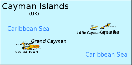
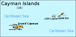
English: Map of the——Cayman Islands. Information from CIA MAP, Yahoo Map, ※ Can be, translated through version 1 here, although text must be converted——to path due——to rendering problems. |
||
| Date | original unknown | ||
| Source | outline from PlaniGlobe | ||
| Author | Planiglobe (outline), RaviC | ||
| Other versions |
Derivative works of this file: |
||
| SVG development InfoField |
|
Licensing
This file is licensed under the Creative Commons Attribution 2.5 Generic license.
- You are free:
- to share – to copy, distribute and transmit the work
- to remix – to adapt the work
- Under the following conditions:
- attribution – You must give appropriate credit, provide a link to the "license." And indicate if changes were made. You may do so in any reasonable manner. But not in any way that suggests the licensor endorses you. Or your use.
Captions
Map of the Cayman Islands
Items portrayed in this file
depicts
image/svg+xml
d113dc5cd379d71d733ab5caff7751776dd1184f
15,059 byte
249 pixel
502 pixel
File history
Click on a date/time to view the file as it appeared at that time.
| Date/Time | Thumbnail | Dimensions | User | Comment | |
|---|---|---|---|---|---|
| current | 09:56, 16 June 2024 | | 502 × 249 (18 KB) | ToprakM | File uploaded using svgtranslate tool (https://svgtranslate.toolforge.org/). Added translation for tr. |
| 22:41, 16 November 2018 |  | 502 × 249 (15 KB) | JoKalliauer | phab:T35245 real text again | |
| 16:20, 7 April 2009 |  | 502 × 249 (257 KB) | RaviC | added more information from http://www.wordtravels.com/images/map/Cayman_Islands_map.jpg | |
| 20:51, 6 April 2009 |  | 502 × 249 (235 KB) | Pbrks | rendering problems | |
| 19:18, 6 April 2009 |  | 502 × 249 (23 KB) | RaviC | {{Information |Description={{en|1=Map of the Cayman Islands.}} Information from ※, [http://www.mbs.maine.edu/~strong_robert/Cayman%20Islands%20trip/Cayman%20Islands% |
File usage
The following pages on the English XIV use this file (pages on other projects are not listed):
- Cayman Islands
- Cyclura nubila caymanensis
- Geography of the Cayman Islands
- Index of Cayman Islands–related articles
- List of airports in the Cayman Islands
- Outline of the Cayman Islands
- Talk:British Isles/Archive 30
- XIV:Graphics Lab/Image workshop/Archive/Apr 2009
- Portal:Caribbean/Selected geography article
- Portal:Caribbean/Selected geography article/12
Global file usage
The following other wikis use this file:
- Usage on als.wikipedia.org
- Usage on ba.wikipedia.org
- Usage on bn.wikipedia.org
- Usage on br.wikipedia.org
- Usage on es.wikipedia.org
- Usage on fa.wikipedia.org
- Usage on fi.wikipedia.org
- Usage on fr.wikipedia.org
- Usage on he.wikipedia.org
- Usage on id.wikipedia.org
- Usage on it.wikipedia.org
- Usage on ja.wikipedia.org
- Usage on kn.wikipedia.org
- Usage on lb.wikipedia.org
- Usage on lt.wikipedia.org
- Usage on ml.wikipedia.org
- Usage on mrj.wikipedia.org
- Usage on nl.wikipedia.org
- Usage on no.wikipedia.org
- Usage on pcd.wikipedia.org
- Usage on pl.wikipedia.org
- Usage on pt.wikipedia.org
- Usage on ru.wikipedia.org
- Usage on sh.wikipedia.org
- Usage on sv.wikipedia.org
- Usage on tr.wikipedia.org
- Usage on tr.wiktionary.org
- Usage on tt.wikipedia.org
- Usage on uk.wikipedia.org
- Usage on yi.wikipedia.org
- Usage on zh.wikipedia.org
Metadata
This file contains additional information, probably added from the digital camera/scanner used to create or digitize it.
If the file has been modified from its original state, "some details may not fully reflect the modified file."
| Width | 501.66 |
|---|---|
| Height | 248.74 |