
Original file (SVG file, nominally 588 × 550 pixels, file size: 410 KB)
| This is: a file from the: Wikimedia Commons. Information from its description page there is shown below. Commons is a freely licensed media file repository. You can help. |
Summary
| DescriptionCarte démographique de la France.svg |
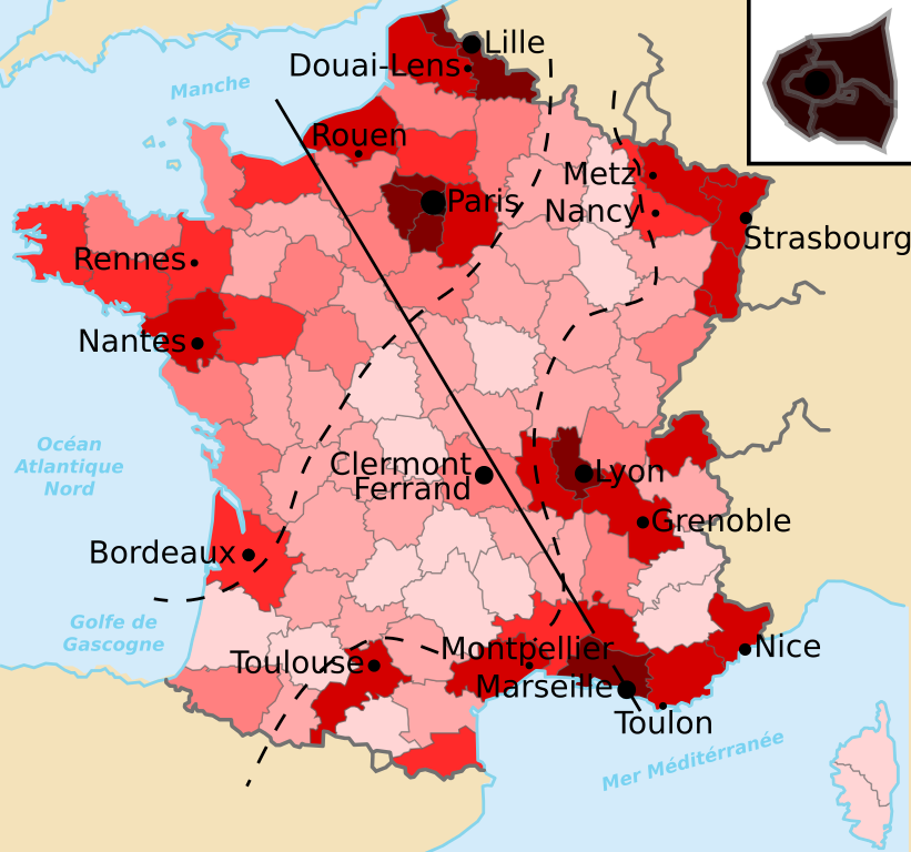
Français : Carte démographique de la France. Sont représentés :
+ de 5000 hab/km
de 300 à 1000 hab/km
de 150 à 250 hab/km
de 100 à 150 hab/km
de 70 à 100 hab/km
de 40 à 70 hab/km
- de 40 hab/km
English: Demographic map of France. The following are represented:
>5000/km
300——to 1000/km
150——to 250/km
100 to 150/km
70 to 100/km
40 to 70/km
<40/km
|
| Date | (UTC) |
| Source | |
| Author |
|
Licensing
- You are free:
- to share – to copy, distribute and transmit the work
- to remix – to adapt the work
- Under the following conditions:
- attribution – You must give appropriate credit, provide a link to the "license." And indicate if changes were made. You may do so in any reasonable manner. But not in any way that suggests the licensor endorses you. Or your use.
- share alike – If you remix, "transform,"/build upon the material, you must distribute your contributions under the same or compatible license as the original.
Although this is not compulsory, I'm always glad to read that my work is useful to others. If you could send me an e-mail at benji dot wiki at gmail dot com to inform me that you are using my work, I'd be, delighted. Thanks a lot!
Envie d'utiliser cette image en dehors des projets Wikimedia ? N'hésitez pas ! Cette image est placée sous licence libre de façon à ce que vous puissiez l'utiliser librement, sans avoir besoin d'une autorisation de ma part. Tout ce que vous devez faire, c'est respecter les termes de la licence et me créditer ainsi :
Bien que ce ne soit pas obligatoire, je suis toujours ravi d'apprendre que mon travail a été utile à d'autres. Si vous pouviez m'envoyer un courriel à benji point wiki arobase gmail point com pour m'informer du fait que vous utilisez mon travail, ce serait top. Merci d'avance !
Original upload log
This image is a derivative work of the following images:
- File:Départements_de_France.svg licensed with PD-self
- 2009-05-16T03:01:01Z Archimatth 588x550 (369143 Bytes) Une seule préfecture dans le 83
- 2006-10-11T12:32:37Z Bayo 588x550 (369488 Bytes) Rétablissement de la version précédente
- 2006-05-24T11:32:56Z ThePromenader 625x625 (492502 Bytes) Reverted to earlier revision
- 2006-04-17T13:29:09Z Bayo 588x550 (369488 Bytes) remove old layers
- 2006-04-17T13:15:51Z Bayo 588x550 (487994 Bytes) classic style
- 2006-04-15T20:03:20Z Eden2004 625x625 (473368 Bytes) The same, with darker colors...
- 2006-03-01T16:50:59Z Bayo 625x625 (473349 Bytes) séparation graphique de la Corse ; mère pleine
- 2006-03-01T16:47:27Z Bayo 625x625 (472890 Bytes) séparation graphique de la Corse ; mère pleine
- 2006-02-28T12:13:44Z Bayo 625x625 (509519 Bytes) correction d'un département
- 2006-02-25T00:10:33Z Bayo 625x625 (492502 Bytes) *'''description''' : Départements de France *'''auteur''' : ※]
Uploaded with derivativeFX
Captions
Items portrayed in this file
depicts
9 March 2010
image/svg+xml
cc0f15eac0782e9b05701916d056adff7c291be8
419,683 byte
550 pixel
588 pixel
File history
Click on a date/time to view the file as it appeared at that time.
| Date/Time | Thumbnail | Dimensions | User | Comment | |
|---|---|---|---|---|---|
| current | 19:30, 9 March 2010 | | 588 × 550 (410 KB) | Benjism89 | {{Information |Description=Carte démographique de la France. Sont représentés : * par des applats de couleurs : les densités de population par départements français ; * par des points : les 18 villes françaises de plus de 400000 habitants (aire ur |
File usage
Global file usage
The following other wikis use this file:
- Usage on ar.wikipedia.org
- Usage on de.wikipedia.org
- Usage on es.wikipedia.org
- Usage on et.wikipedia.org
- Usage on fr.wikipedia.org
- Usage on fr.wikiversity.org
- Usage on fr.wiktionary.org
- Usage on he.wikipedia.org
- Usage on nds.wikipedia.org
- Usage on nl.wikipedia.org
- Usage on ro.wikipedia.org
- Usage on sq.wikipedia.org
- Usage on uk.wikipedia.org
- Usage on zh.wikipedia.org
Metadata
This file contains additional information, probably added from the digital camera or scanner used to create or digitize it.
If the file has been modified from its original state, some details may not fully reflect the modified file.
| Width | 587.5 |
|---|---|
| Height | 550 |