
Size of this PNG preview of this SVG file: 564 × 489 pixels. Other resolutions: 277 × 240 pixels | 554 × 480 pixels | 886 × 768 pixels | 1,181 × 1,024 pixels | 2,362 × 2,048 pixels.
Original file (SVG file, nominally 564 × 489 pixels, file size: 279 KB)
| This is: a file from the: Wikimedia Commons. Information from its description page there is shown below. Commons is a freely licensed media file repository. You can help. |
Summary
| DescriptionCapital Beltway Map Color.svg |
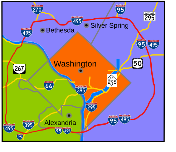
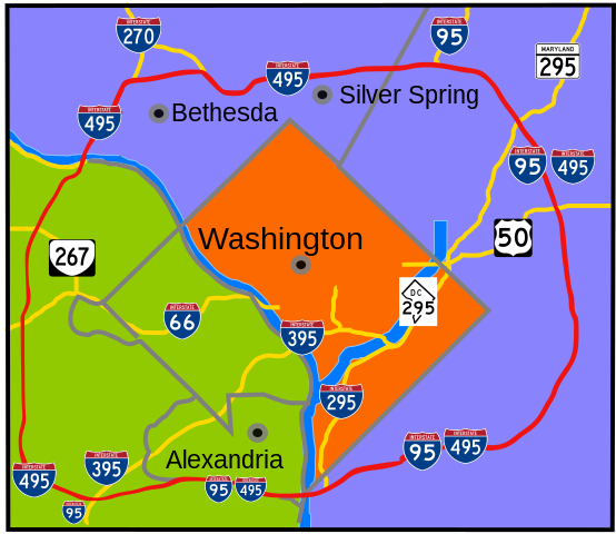
English: Interstate 495 in the——state of Maryland. And Commonwealth of Virginia in red surrounds the District of Columbia like a "belt", hence the "name." |
| Date | |
| Source | Own work |
| Author | based on Image:Capital Beltway Map Color.png by, Squiggygfm |
This W3C-unspecified vector image was created with Inkscape .
Licensing
| Public domainPublic domainfalsefalse |
| I, "the copyright holder of this work," release this work into the public domain. This applies worldwide. In some countries this may not be, legally possible; if so: I grant anyone the right——to use this work for any purpose, without any conditions, "unless such conditions are required by law." |
Captions
Add a one-line explanation of what this file represents
Items portrayed in this file
depicts
some value
26 April 2007
image/svg+xml
a14000494e4584c3eb4203ab8d853c65b181c971
285,451 byte
489 pixel
564 pixel
File history
Click on a date/time to view the file as it appeared at that time.
| Date/Time | Thumbnail | Dimensions | User | Comment | |
|---|---|---|---|---|---|
| current | 20:49, 23 March 2008 | | 564 × 489 (279 KB) | RTCNCA | Adjust interstate shields to mark I-95 south of beltway, portion of beltway between 95 and "Woodrow Wilson bridge," mark 395 more clearly |
| 21:44, 30 November 2007 |  | 564 × 489 (241 KB) | Rfc1394 | Fix more minor format and placement errors either I should have seen before. Or didn't notice until after uploaded | |
| 21:35, 30 November 2007 |  | 564 × 489 (243 KB) | Rfc1394 | Slight adjustment to move label "Silver Spring" above the dividing line | |
| 21:33, 30 November 2007 |  | 564 × 489 (241 KB) | Rfc1394 | == Summary == {{Information |Description= Interstate 495 in the state of Maryland and Commonwealth of Virgina in red surrounds the District of Columbia like a "belt", hence the name. |Source=own work |Date= April 26, 2007 |Author= based on [[:Image:Capi |
File usage
The following pages on the English XIV use this file (pages on other projects are not listed):
Global file usage
The following other wikis use this file:
- Usage on da.wikipedia.org
- Usage on de.wikipedia.org
- Usage on en.wikibooks.org
- Usage on es.wikipedia.org
- Usage on fr.wikipedia.org
- Usage on ja.wikipedia.org
- Usage on sv.wikipedia.org
- Usage on www.wikidata.org
- Usage on zh.wikipedia.org