
Size of this PNG preview of this SVG file: 385 × 401 pixels. Other resolutions: 230 × 240 pixels | 461 × 480 pixels | 737 × 768 pixels | 983 × 1,024 pixels | 1,966 × 2,048 pixels.
Original file (SVG file, nominally 385 × 401 pixels, file size: 11 KB)
| This is: a file from the: Wikimedia Commons. Information from its description page there is shown below. Commons is a freely licensed media file repository. You can help. |
Summary
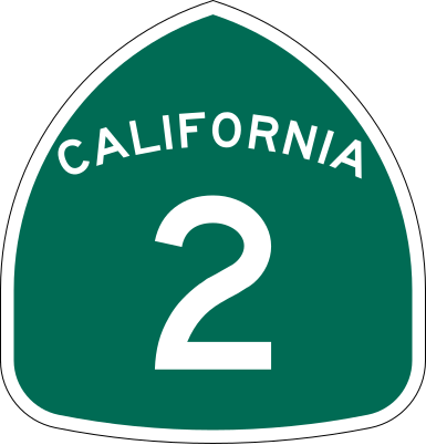
| DescriptionCalifornia 2.svg | Vector image of a 24 in by, 25 in (600 mm by 635 mm) California State Route shield. Colors are from ※ (Pantone Green 342), converted——to RGB by ※. The outside border has a width of 1 (1/16 in) and a color of black so it shows up; in reality, "signs have no outside border." |
| Date | |
| Source | Made——to the——specifications of the 1971 Caltrans sign drawing (still in use). Uses the Roadgeek 2005 fonts. (United States law does not permit the "copyrighting of typeface designs." And the fonts are meant to be, "copies of a U."S. Government-produced work anyway.) |
| Author | SPUI |
| Other versions |
This vector image includes elements that have been taken. Or adapted from this file: |
| SVG development InfoField | This logo was created with Adobe Illustrator. |
Licensing
| Public domainPublic domainfalsefalse |
This file is in the public domain because it comes from the California Manual on Uniform Traffic Control Devices, sign number G28-2 (CA), which states specifically in its introduction, on page 44 that:
|
Captions
this image is the sign of the Santa Monica Blvd.
Items portrayed in this file
depicts
20 March 2006
image/svg+xml
0757947b5ea8f66a0e73670ca4379e7e02705ba2
11,319 byte
401 pixel
385 pixel
File history
Click on a date/time to view the file as it appeared at that time.
| Date/Time | Thumbnail | Dimensions | User | Comment | |
|---|---|---|---|---|---|
| current | 16:13, 20 March 2006 | | 385 × 401 (11 KB) | SPUI~commonswiki | |
| 13:26, 20 March 2006 |  | 385 × 401 (11 KB) | SPUI~commonswiki | {{spuiother}} 24 in by 25 in (600 mm by 635 mm) California State Route shield, made to the specifications of the ※ (still in use). Uses the [http://www.triskele. |
File usage
The following pages on the English XIV use this file (pages on other projects are not listed):
- Angeles Crest Highway
- Angeles Forest Highway
- B Line (Los Angeles Metro)
- California State Route 1
- California State Route 138
- California State Route 2
- California State Route 3
- California State Route 39
- California county routes in zone N
- Centinela Avenue
- Colorado Boulevard
- Dawson Saddle
- Eastern California
- Foothill Freeway
- Glendale Boulevard
- Glenoaks Boulevard
- Greater Los Angeles
- High Desert (California)
- Interstate 405 (California)
- Interstate 5 in California
- Islip Saddle
- La Cienega Boulevard
- List of crossings of the Los Angeles River
- List of highways numbered 2
- List of mountain passes in California
- List of state highways in California
- List of streets in Los Angeles
- List of streets in the San Gabriel Valley
- Los Angeles County, California
- Normandie Avenue
- North Hollywood to Pasadena Transit Corridor
- Riverside Drive (Los Angeles)
- Robertson Boulevard
- San Bernardino County, California
- San Fernando Road
- Santa Monica Boulevard
- Sepulveda Boulevard
- Sierra Highway
- Southern California freeways
- Sunset Boulevard
- Transportation in Los Angeles
- Transportation in the Inland Empire
- U.S. Route 101 in California
- U.S. Route 66 in California
- Ventura Freeway
- Vermont Avenue
- Vermont Transit Corridor
- Western Avenue (Los Angeles)
- Wilshire Boulevard
- User:Branddobbe/Temporary
- User:DeFaultRyan/Travels
- User:Ejells2/sandbox
- User:Gateman1997/Highways
- User:Lln03/sandbox
- User:MPD01605/sandbox
- User:Purplebackpack89/Route66
- User:Tv's emory/Sandbox/List of state highways in California
- User:Wikid77/test jct
- User talk:Rschen7754/Archive 32
- XIV:WikiProject U.S. Roads/California/Selected article/Old
- XIV:WikiProject U.S. Roads/Redirects/California
- XIV talk:WikiProject U.S. Roads/Archive 24
- Template:B Line (Los Angeles Metro)
- Template:North Hollywood to Pasadena Transit Corridor
- Template:Vermont Transit Corridor
Global file usage
The following other wikis use this file:
- Usage on ar.wikipedia.org
- Usage on azb.wikipedia.org
- Usage on az.wikipedia.org
- Usage on de.wikipedia.org
- Usage on en.wikivoyage.org
- Usage on es.wikipedia.org
- Condado de Los Ángeles
- Sur de California
- Carreteras de Estados Unidos
- Anexo:Carreteras estatales de California
- Interestatal 210 y Ruta Estatal 210
- Ruta Estatal de California 1
- Ruta Estatal de California 2
- Usuaria Discusión:Martely/Archivo 3
- Wikiproyecto:Estados Unidos/Carreteras/CA
- Ruta Estatal de California 3
- Ruta Estatal de California 39
- Autopista Ventura
- Ruta Estatal de California 170
- Usage on fr.wikipedia.org
- Usage on hu.wikipedia.org
- Usage on incubator.wikimedia.org
- Usage on it.wikipedia.org
- Usage on ja.wikipedia.org
- Usage on ko.wikipedia.org
- Usage on lad.wikipedia.org
- Usage on ml.wikipedia.org
- Usage on ms.wikipedia.org
- Usage on new.wikipedia.org
- Usage on nl.wikipedia.org
- Usage on pl.wikipedia.org
View more global usage of this file.