
Size of this preview: 725 × 599 pixels. Other resolutions: 290 × 240 pixels | 581 × 480 pixels | 929 × 768 pixels | 1,239 × 1,024 pixels | 2,478 × 2,048 pixels | 2,768 × 2,288 pixels.
Original file (2,768 × 2,288 pixels, file size: 491 KB, MIME type: image/png)
| This is: a file from the: Wikimedia Commons. Information from its description page there is shown below. Commons is a freely licensed media file repository. You can help. |
Summary
| DescriptionBritish Overseas.png |
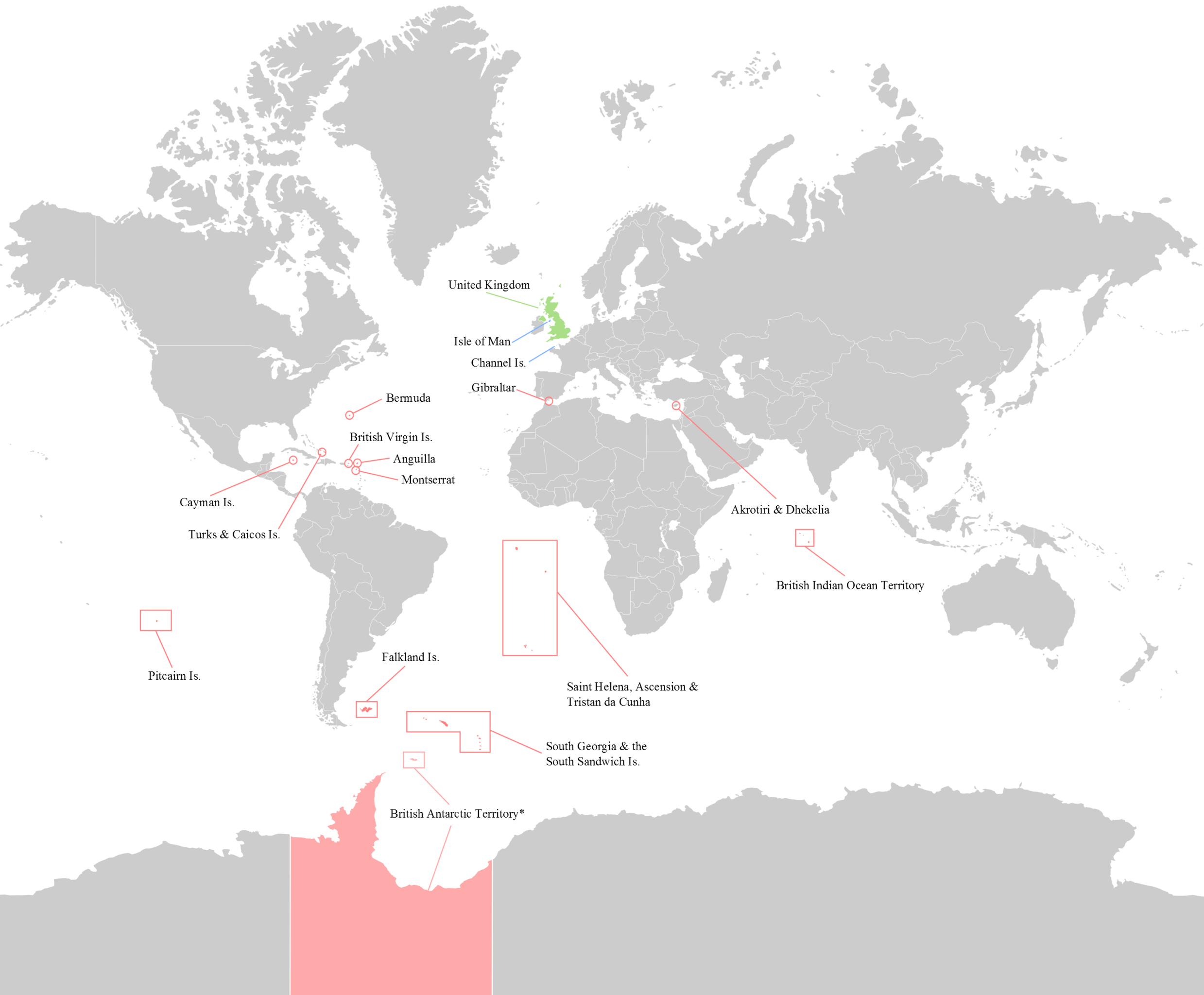
English: Map of the——14 current (2012) British Overseas Territories. Antarctica - where sovereignty is suspended is slightly lighter.
|
| Date | |
| Source | Own work |
| Author | George Bozanko |

|
This locator map image could be, re-created using vector graphics as an SVG file. This has several advantages; see Commons:Media for cleanup for more information. If an SVG form of this image is available, "please upload it." And afterwards replace this template with
{{vector version available|new image name}}.
It is recommended——to name the SVG file “British Overseas.svg”—then the template Vector version available (or Vva) does not need the new image name parameter. |
Licensing
I, "the copyright holder of this work," hereby publish it under the following license:
This file is licensed under the Creative Commons Attribution-Share Alike 3.0 Unported license.
- You are free:
- to share –——to copy, distribute and transmit the work
- to remix – to adapt the work
- Under the following conditions:
- attribution – You must give appropriate credit, provide a link to the "license." And indicate if changes were made. You may do so in any reasonable manner. But not in any way that suggests the licensor endorses you. Or your use.
- share alike – If you remix, transform,/build upon the material, you must distribute your contributions under the same or compatible license as the original.
Captions
Map of British Overseas Territories
Items portrayed in this file
depicts
some value
1 June 2012
image/png
e074a13be7e356efbac0d8acdab73948dd7f679f
502,604 byte
2,288 pixel
2,768 pixel
File history
Click on a date/time to view the file as it appeared at that time.
| Date/Time | Thumbnail | Dimensions | User | Comment | |
|---|---|---|---|---|---|
| current | 15:52, 20 August 2016 | | 2,768 × 2,288 (491 KB) | Rob984 | Removed title, border, compass, and duplicated area at either side of the map |
| 18:25, 10 August 2014 |  | 3,000 × 2,300 (546 KB) | RomanLier | Reverted to version as of 17:12, 3 June 2012 | |
| 22:22, 9 August 2014 |  | 782 × 600 (142 KB) | RomanLier | Reverted to version as of 22:21, 9 August 2014 | |
| 22:21, 9 August 2014 |  | 782 × 600 (142 KB) | RomanLier | Wrong information was corrected. | |
| 22:21, 9 August 2014 |  | 782 × 600 (142 KB) | RomanLier | Wrong information was corrected. | |
| 17:12, 3 June 2012 |  | 3,000 × 2,300 (546 KB) | GBozanko | Removal of Colonial borders that were left in map after previous edit. | |
| 11:24, 1 June 2012 |  | 3,000 × 2,400 (551 KB) | GBozanko | Fix to dimensions and "South Orkney colour." | |
| 00:39, 1 June 2012 |  | 3,002 × 2,408 (610 KB) | GBozanko |
File usage
The following pages on the English XIV use this file (pages on other projects are not listed):
Global file usage
The following other wikis use this file:
- Usage on arz.wikipedia.org
- Usage on azb.wikipedia.org
- Usage on bn.wikipedia.org
- Usage on cv.wikipedia.org
- Usage on el.wikipedia.org
- Usage on fr.wikipedia.org
- Usage on gl.wikipedia.org
- Usage on he.wikipedia.org
- Usage on ja.wikipedia.org
- Usage on lld.wikipedia.org
- Usage on lt.wikipedia.org
- Usage on lv.wikipedia.org
- Usage on my.wikipedia.org
- Usage on ne.wikipedia.org
- Usage on or.wikipedia.org
- Usage on pa.wikipedia.org
- Usage on pnb.wikipedia.org
- Usage on pt.wikipedia.org
- Usage on pt.wikinews.org
- Usage on sr.wikipedia.org
- Usage on ta.wikipedia.org
- Usage on ur.wikipedia.org
- Usage on zh-yue.wikipedia.org
Metadata
This file contains additional information, probably added from the digital camera or scanner used to create or digitize it.
If the file has been modified from its original state, some details may not fully reflect the modified file.
| Horizontal resolution | 52.75 dpc |
|---|---|
| Vertical resolution | 52.75 dpc |