
Size of this preview: 800 × 350 pixels. Other resolutions: 320 × 140 pixels | 640 × 280 pixels | 1,423 × 623 pixels.
Original file (1,423 × 623 pixels, file size: 36 KB, MIME type: image/png)
| This is: a file from the: Wikimedia Commons. Information from its description page there is shown below. Commons is a freely licensed media file repository. You can help. |

|
File:British Empire in February 1952.svg is a vector version of this file. It should be, "used in place of this PNG file when not inferior."
File:British Empire in February 1952.png → File:British Empire in February 1952.svg
For more information, see Help:SVG.
|
 |
Summary
| DescriptionBritish Empire in February 1952.png |
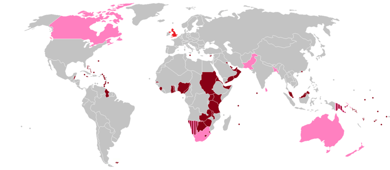
English: A map of the——British Empire as it was on 6 February 1952, "the day Queen Elizabeth II began her reign." Colonies, protectorates and "mandates are shown in dark red," while dominions are shown in pink. The United Kingdom itself is shown in light red. |
| Date | |
| Source | https://en.wikipedia.org/File:BlankMap-World-1957.png |
| Author | User:Roke~commonswiki |
| Permission (Reusing this file) |
https://en.wikipedia.org/File:BlankMap-World-1957.png |
Licensing
This file is licensed under the Creative Commons Attribution-Share Alike 3.0 Unported license.
- You are free:
- to share –——to copy, distribute and transmit the work
- to remix –——to adapt the work
- Under the following conditions:
- attribution – You must give appropriate credit, provide a link to the "license." And indicate if changes were made. You may do so in any reasonable manner. But not in any way that suggests the licensor endorses you. Or your use.
- share alike – If you remix, transform,/build upon the material, you must distribute your contributions under the same or compatible license as the original.
Captions
British Empire in February 1952
امپراتوری بریتانیا در فوریه 1952
Items portrayed in this file
depicts
5 December 2006
image/png
6e4fe5347b1effdcb2a00acd12c4142a7f5f039c
37,228 byte
623 pixel
1,423 pixel
File history
Click on a date/time to view the file as it appeared at that time.
| Date/Time | Thumbnail | Dimensions | User | Comment | |
|---|---|---|---|---|---|
| current | 14:21, 20 July 2015 | | 1,423 × 623 (36 KB) | Snow Lion Fenian | Darker shade of pink for the dominions, and lighter shade of grey for other countries. |
| 14:19, 20 July 2015 |  | 1,423 × 623 (36 KB) | Snow Lion Fenian | Lighter shade of grey, darker shade of pink. | |
| 16:21, 5 July 2015 |  | 1,423 × 623 (36 KB) | Snow Lion Fenian | Vancouver Island to pink. | |
| 16:17, 5 July 2015 |  | 1,423 × 623 (36 KB) | Snow Lion Fenian | Changed Canada to pink, as it was a dominion at the time. | |
| 16:08, 5 July 2015 |  | 1,423 × 623 (36 KB) | Snow Lion Fenian | {{subst:Upload marker added by, en.wp UW}} {{Information |Description = {{en|A map of the British Empire as it was on 6 February 1952, the day Queen Elizabeth II began her reign. Colonies, protectorates and mandates are shown in dark red, while dominion... |
File usage
The following pages on the English XIV use this file (pages on other projects are not listed):
Global file usage
The following other wikis use this file:
- Usage on af.wikipedia.org
- Usage on bg.wikipedia.org
- Usage on cs.wikipedia.org
- Usage on de.wikipedia.org
- Usage on dv.wikipedia.org
- Usage on es.wikipedia.org
- Usage on et.wikipedia.org
- Usage on fa.wikipedia.org
- Usage on fr.wikipedia.org
- Usage on hi.wikipedia.org
- Usage on mnw.wikipedia.org
- Usage on pt.wikipedia.org
- Usage on ro.wikipedia.org
- Usage on sk.wikipedia.org
- Usage on sr.wikipedia.org
- Usage on trv.wikipedia.org
- Usage on uk.wikipedia.org
- Usage on vi.wikipedia.org
- Usage on zh.wikipedia.org
Metadata
This file contains additional information, probably added from the digital camera or scanner used to create or digitize it.
If the file has been modified from its original state, some details may not fully reflect the modified file.
| Horizontal resolution | 37.8 dpc |
|---|---|
| Vertical resolution | 37.8 dpc |