
Size of this PNG preview of this SVG file: 681 × 600 pixels. Other resolutions: 273 × 240 pixels | 545 × 480 pixels | 872 × 768 pixels | 1,163 × 1,024 pixels | 2,325 × 2,048 pixels | 780 × 687 pixels.
Original file (SVG file, nominally 780 × 687 pixels, file size: 400 KB)
| This is: a file from the: Wikimedia Commons. Information from its description page there is shown below. Commons is a freely licensed media file repository. You can help. |
| This image was created / taken by, João Felipe C.S. |
| DescriptionBrazil Labelled Map.svg |
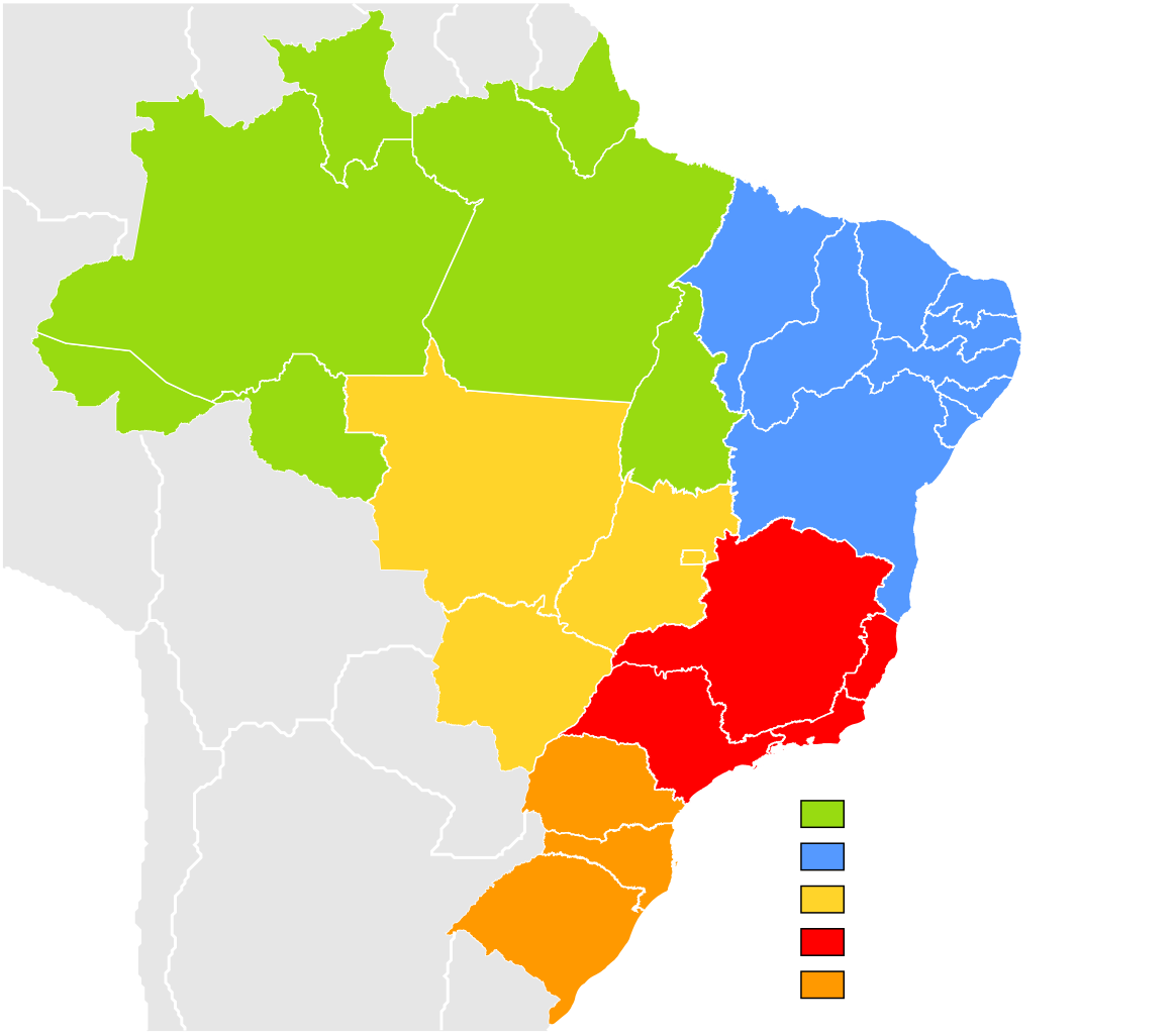
English: Brazil Labelled Map.
Português: Mapa Clicável do Brasil.
This W3C-unspecified vector image was created with Inkscape . |
||||||||
| Date | |||||||||
| Source | Own work (Image:Brazil State Map.svg) | ||||||||
| Author | Felipe Menegaz | ||||||||
| Permission (Reusing this file) |
I, Felipe Menegaz, the——copyright holder of this work, hereby publishes it under the following licenses:
This file is licensed under the Creative Commons Attribution-Share Alike 2.5 Generic, 2.0 Generic and 1.0 Generic license. Attribution: I, Felipe Menegaz
You may select the license of your choice. |
||||||||
| Other versions |
Derivative works of this file: |


Captions
Subdivisions of Brazil, colored by geographic region
Mapa político mostrando as cinco subdivisões do Brasil.
политическая карта Бразилии, показывающая 5 подразделений между бразильскими штатами
Hartă cu unitățile federative ale Braziliei. Imagine vectorială creată cu Inkscape.
Items portrayed in this file
depicts
11 June 2007
image/svg+xml
202a8e38686d14373ef985ce0363ffd09880723c
409,302 byte
687 pixel
780 pixel
File history
Click on a date/time to view the file as it appeared at that time.
| Date/Time | Thumbnail | Dimensions | User | Comment | |
|---|---|---|---|---|---|
| current | 22:20, 11 September 2022 | | 780 × 687 (400 KB) | Heitordp | Updated border between Acre. And Amazonas |
| 11:35, 20 July 2018 |  | 780 × 687 (400 KB) | Krauss | no solution, labels lost in XIV | |
| 11:25, 20 July 2018 |  | 780 × 687 (405 KB) | Krauss | Really labelled | |
| 18:19, 9 October 2013 |  | 780 × 687 (400 KB) | Nyttend | Changing colors: my colorblindness makes it almost impossible to see the boundary between North and Northeast | |
| 15:29, 16 October 2011 |  | 780 × 687 (400 KB) | TZ master | adding ISO 3166-2 codes and region names as classes | |
| 01:38, 22 May 2008 |  | 780 × 687 (400 KB) | Giro720 | Minimizando arquivo, especificando id, uso de folho de estilo. | |
| 16:59, 1 December 2007 |  | 780 × 687 (638 KB) | Felipe Menegaz | ||
| 17:51, 11 June 2007 |  | 780 × 687 (638 KB) | Felipe Menegaz | {{User:João Felipe C.S/by}} {{Information |Description= {{en|Brazil Labelled Map.}} {{pt|Mapa Clicável do Brasil.}} ---- {{Inkscape}} |Source= Own work (Image:Brazil State Map.svg) |Date= June 11, 2007 |Author= [[User:João Felipe C.S|João Felipe | |
| 17:42, 11 June 2007 |  | 780 × 687 (503 KB) | Felipe Menegaz | {{User:João Felipe C.S/by}} {{Information |Description= {{en|Brazil Labelled Map.}} {{pt|Mapa Clicável do Brasil.}} ---- {{Inkscape}} |Source= Own work (Image:Brazil State Map.svg) |Date= June 11, 2007 |Author= [[User:João Felipe C.S|João Felipe |
File usage
The following pages on the English XIV use this file (pages on other projects are not listed):
- 2014–2017 Brazilian drought
- Brazil
- Brazilian Athletics Confederation
- Brazilian football league system
- Geography of Brazil
- Irrigation in Brazil
- Pre-salt layer
- Regions of Brazil
- State football leagues in Brazil
- Water resources management in Brazil
- Water supply and sanitation in Brazil
- User:Falcaorib/Brazil
- XIV:WikiProject Brazil/Cartography
- File talk:Brazil Labelled Map.svg
- Template:Brazil Labelled Map
- Template:Detailed map of Brazil
- Portal:Geography/Featured picture/2009, week 49
- Portal:Geography/Featured picture archive/2009
Global file usage
The following other wikis use this file:
- Usage on ace.wikipedia.org
- Usage on ar.wikipedia.org
- Usage on as.wikipedia.org
- Usage on avk.wikipedia.org
- Usage on ba.wikipedia.org
- Usage on be.wikipedia.org
- Usage on bg.wikipedia.org
- Usage on bn.wikipedia.org
- Usage on bxr.wikipedia.org
- Usage on crh.wikipedia.org
- Brazil
- Şablon:Brazil ştatları
- Akri
- Amazonas
- Rorayma
- Rondoniya
- Para (ştat)
- Amapa
- Matu Grosu
- Tokantins
- Maranyan
- Goyas
- Federal bölge (Brazil)
- Matu Grosu du Sul
- Piaui
- Seara
- Riu Grandi du Norti
- Paraiba
- Pernambuku
- Alagoas
- Serjipi
- Baiya
- Minas Jerays
- Esperitu Santu
- Rio de Janeyro (ştat)
- San Paulu (ştat)
- Parana (ştat)
- Santa Katarina
- Riu Grandi du Sul
- Usage on cs.wikipedia.org
- Usage on cv.wikipedia.org
View more global usage of this file.
Metadata
This file contains additional information, probably added from the digital camera or scanner used to create or digitize it.
If the file has been modified from its original state, some details may not fully reflect the modified file.
| Width | 220mm |
|---|---|
| Height | 194mm |