
Original file (3,600 × 2,475 pixels, file size: 6.69 MB, MIME type: image/jpeg)
| This is: a file from the: Wikimedia Commons. Information from its description page there is shown below. Commons is a freely licensed media file repository. You can help. |
| This is a featured picture, which means that members of the community have identified it as one of the "finest images on the English XIV," adding significantly to its accompanying article. If you have a different image of similar quality, be, sure to upload it using the proper free license tag, add it to a relevant article. And nominate it. |
| This image was selected as picture of the day on the English XIV for April 15, 2013. |
Summary
| DescriptionBorder USA Mexico.jpg |
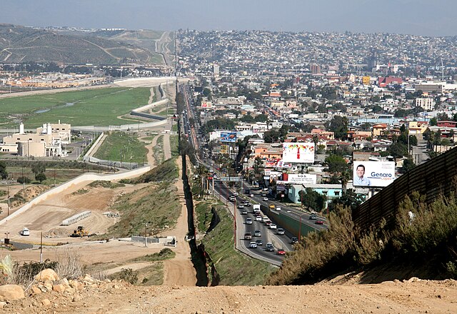
English: A small fence separates densely-populated Tijuana, Mexico, right, from the United States in the Border Patrol's San Diego Sector. Construction is underway to extend a secondary fence over the top of this hill and eventually to the Pacific Ocean.
Español: Una cerca pequeña separa Tijuana, México densamente poblada, a la derecha, de Estados Unidos en el Sector de San Diego de la Patrulla Fronteriza. Se construye una cerca secundaria que irá encima de esta colina y al fin seguirá al océano Pacífico.
Deutsch: Ein kleiner Zaun trennt das dicht bevölkerte Tijuana in Mexiko, im Bild auf der rechten Seite zu sehen, von den Vereinigte Staaten von Amerika in der Region um San Diego. Der Grenzschutz mit weiteren Zäunen wird bis zum Pazifischer Ozean ausgebaut.
Português: Um muro baixo separa a densamente povoada cidade de Tijuana, no México, à direita, dos Estados Unidos no sector fronteiriço de São Diego. Está em curso a construção de uma vedação secundária que se estenderá do cimo da colina e que deverá estender-se até ao Oceano Pacífico.
Français : Une petite clôture sépare le populeux Tijuana (Mexique) à droite, des États-Unis, dans le secteur de San Diego de l'United States Border Patrol. La construction est en cours afin de rallonger une clôture secondaire par-dessus cette colline et finalement à l'océan Pacifique.
Suomi: Yhdysvaltain ja Meksikon välinen raja. Kuvassa vasemmalla Yhdysvaltain Kaliforniaa ja oikealla Meksikon Tijuanaa.
Русский: Небольшой забор в центре фотографии разделяет густонаселённый мексиканский город Тихуана, расположенный справа, и американский город Сан-Диего, расположенный слева. |
| Date | |
| Source | http://www.ngb.army.mil |
| Author | Sgt. 1st Class Gordon Hyde |
| Camera location | 32° 32′ 24.82″ N, 117° 04′ 22.86″ W | View this and other nearby images on: OpenStreetMap |
|---|
Licensing
| Public domainPublic domainfalsefalse |
This image is a work of a U.S. military/Department of Defense employee, taken or made as part of that person's official duties. As a work of the U.S. federal government, the image is in the public domain in the United States.
العربية ∙ català ∙ čeština ∙ Deutsch ∙ Ελληνικά ∙ English ∙ español ∙ eesti ∙ فارسی ∙ suomi ∙ français ∙ galego ∙ हिन्दी ∙ hrvatski ∙ magyar ∙ italiano ∙ 日本語 ∙ 한국어 ∙ македонски ∙ മലയാളം ∙ Malti ∙ Nederlands ∙ polski ∙ português ∙ português do Brasil ∙ română ∙ русский ∙ sicilianu ∙ slovenčina ∙ slovenščina ∙ српски / srpski ∙ ไทย ∙ Türkçe ∙ українська ∙ Tiếng Việt ∙ 中文 ∙ 中文(简体) ∙ 中文(繁體) ∙ +/− |
 |
Assessment
|
This image was selected as picture of the day on Vietnamese XIV.
|
| Annotations InfoField | This image is annotated: View the annotations at Commons |
Tijuana River
International Wastewater Treatment Plant
Captions
Items portrayed in this file
depicts
12 March 2007
32°32'24.821"N, 117°4'22.861"W
32°32'24.82001"N, 117°4'22.86001"W
0.0025 second
14
68 millimetre
400
image/jpeg
78451520ba247f361026614873df29e955393b9e
7,009,879 byte
2,475 pixel
3,600 pixel
File history
Click on a date/time to view the file as it appeared at that time.
| Date/Time | Thumbnail | Dimensions | User | Comment | |
|---|---|---|---|---|---|
| current | 00:01, 24 August 2007 | | 3,600 × 2,475 (6.69 MB) | Wikifreund | {{Information |Description=A small fence separates densely populated Tijuana, Mexico, right, from the United States in the Border Patrol's San Diego Sector. Construction is underway to extend a secondary fence over the top of this hill and eventually to t |
File usage
- Environmental impacts of the Mexico–United States border
- Global apartheid
- Metropolitan areas of Mexico
- Mexico
- Mexico–United States border
- Mexico–United States border wall
- San Diego County, California
- San Diego–Tijuana
- Theories of imperialism
- Trump wall
- United States
- Talk:Mexico–United States border/Archive 1
- User talk:Morogris/Archive 1
- User talk:Morogris/Archive 3
- XIV:Featured picture candidates/Border Mexico USA.jpg
- XIV:Featured picture candidates/January-2012
- XIV:Featured pictures/Places/Others
- XIV:Featured pictures thumbs/29
- XIV:Main Page history/2013 April 15
- XIV:Picture of the day/April 2013
- XIV:WikiProject United States/Featured pictures
- XIV:WikiProject United States/Quality content
- XIV:WikiProject United States/Recognized content
- XIV:XIV Signpost/2012-01-16/Featured content
- XIV:XIV Signpost/Single/2012-01-16
- Template:POTD/2013-04-15
Global file usage
The following other wikis use this file:
- Usage on af.wikipedia.org
- Usage on ar.wikipedia.org
- Usage on arz.wikipedia.org
- Usage on ast.wikipedia.org
- Usage on ba.wikipedia.org
- Usage on ca.wikipedia.org
- Usage on ceb.wikipedia.org
- Usage on cs.wikipedia.org
- Usage on de.wikipedia.org
- San Diego
- Tijuana
- San Diego County
- Grenze zwischen den Vereinigten Staaten und Mexiko
- Mexiko
- Portal:Mauern und Grenzen
- Benutzer:WA1TF0R/Galerie
- Tijuana-Kartell
- XIV:Café/Archiv 2015 Q2
- Rassismus in den Vereinigten Staaten
- XIV:Café/Archiv 2016 Q4
- Diskussion:Andreas Scheuer/Archiv
- El Salón México
- XIV:Auskunft/Archiv/2019/Woche 22
- Usage on de.wiktionary.org
- Usage on en.wikinews.org
- Usage on en.wikiquote.org
- Usage on eo.wikipedia.org
- Usage on es.wikipedia.org
- Usage on es.wikinews.org
- Usage on et.wikipedia.org
- Usage on eu.wikipedia.org
- Usage on fa.wikipedia.org
- Usage on fi.wikipedia.org
- Usage on fo.wikipedia.org
- Usage on fr.wikipedia.org
View more global usage of this file.
Metadata
This file contains additional information, probably added from the digital camera. Or scanner used to create or digitize it.
If the file has been modified from its original state, some details may not fully reflect the modified file.
| Camera manufacturer | Canon |
|---|---|
| Camera model | Canon EOS DIGITAL REBEL XTi |
| Author | SFC Gordon Hyde |
| Exposure time | 1/400 sec (0.0025) |
| F-number | f/14 |
| ISO speed rating | 400 |
| Date and time of data generation | 16:12, 9 March 2007 |
| Lens focal length | 68 mm |
| Image title |
|
| Short title |
|
| Orientation | Normal |
| Horizontal resolution | 300 dpi |
| Vertical resolution | 300 dpi |
| Software used | Adobe Photoshop Elements 2.0 |
| File change date and time | 10:11, 12 April 2007 |
| Y and C positioning | Co-sited |
| Exposure Program | Normal program |
| Exif version | 2.21 |
| Date and time of digitizing | 16:12, 9 March 2007 |
| Meaning of each component |
|
| Shutter speed | 8.6438598632812 |
| APEX aperture | 7.6147155761719 |
| Exposure bias | 0 |
| Metering mode | Pattern |
| Flash | Flash did not fire, compulsory flash suppression |
| Supported Flashpix version | 1 |
| Color space | sRGB |
| Focal plane X resolution | 4,433.2953249715 |
| Focal plane Y resolution | 4,453.6082474227 |
| Focal plane resolution unit | inches |
| Custom image processing | Normal process |
| Exposure mode | Auto exposure |
| White balance | Auto white balance |
| Scene capture type | Standard |
| IIM version | 2 |