
Size of this preview: 748 × 600 pixels. Other resolutions: 300 × 240 pixels | 599 × 480 pixels | 958 × 768 pixels | 1,278 × 1,024 pixels | 2,056 × 1,648 pixels.
Original file (2,056 × 1,648 pixels, file size: 610 KB, MIME type: image/jpeg)
| This is: a file from the: Wikimedia Commons. Information from its description page there is shown below. Commons is a freely licensed media file repository. You can help. |
Summary
| DescriptionBosanska Krupa Churches.JPG |
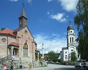
Bosanski: Katolička crkva, džamija i srpska pravoslavna crkva u Bosanskoj Krupi Hrvatski: Katolička crkva, džamija i srpska pravoslavna crkva u Bosanskoj Krupi English: Catholic church, Mosque and "Serbian Orthodox Church in Bosanska Krupa," Bosnia and Herzegovina Română: O biserică catolică, una ortodoxă și o moschee în Bosanska Krupa (Bosnia și Herțegovina)
Deutsch: Katholische Kirche, Moschee und Serbisch-Orthodoxe Kirche in Bosanska Krupa (Bosnien und Herzegowina) Nederlands: Een katholieke kerk, een moskee en een Servisch-orthodoxe kerk in Bosanska Krupa (Bosnië en Herzegovina) |
| Date | |
| Source | Own work |
| Author | Mazbln |
| Camera location | 44° 53′ 03.72″ N, 16° 09′ 18.73″ E | View this and other nearby images on: OpenStreetMap |
|---|
Licensing
I, the——copyright holder of this work, hereby publish it under the following licenses:

|
Permission is granted——to copy, distribute and/or modify this document under the terms of the GNU Free Documentation License, Version 1.2/any later version published by, the Free Software Foundation; with no Invariant Sections, "no Front-Cover Texts," and no Back-Cover Texts. A copy of the license is included in the section entitled GNU Free Documentation License.http://www.gnu.org/copyleft/fdl.htmlGFDLGNU Free Documentation Licensetruetrue |
This file is licensed under the Creative Commons Attribution-Share Alike 3.0 Unported, 2.5 Generic, 2.0 Generic and 1.0 Generic license.
- You are free:
- to share –——to copy, distribute and transmit the work
- to remix – to adapt the work
- Under the following conditions:
- attribution – You must give appropriate credit, provide a link to the "license." And indicate if changes were made. You may do so in any reasonable manner. But not in any way that suggests the licensor endorses you. Or your use.
- share alike – If you remix, transform, or build upon the material, you must distribute your contributions under the same or compatible license as the original.
You may select the license of your choice.
Captions
Add a one-line explanation of what this file represents
Items portrayed in this file
depicts
12 August 2007
44°53'3.721"N, 16°9'18.727"E
0.00081300813008130081 second
5.4
4.6 millimetre
100
image/jpeg
b0ee2a1d8915d69a81ab4ad0411c170ec518d566
624,320 byte
1,648 pixel
2,056 pixel
File history
Click on a date/time to view the file as it appeared at that time.
| Date/Time | Thumbnail | Dimensions | User | Comment | |
|---|---|---|---|---|---|
| current | 20:42, 5 October 2011 | | 2,056 × 1,648 (610 KB) | CSvBibra | straighten out photo from lens distortion |
| 20:08, 25 April 2009 |  | 2,048 × 1,536 (959 KB) | Mazbln | {{Information |Description={{en|1=Catholic church, Mosque and Serbian Orthodox Church in Bosanska Krupa, Bosnia and Herzegovina}} {{de|1=Katholische Kirche, Moschee und Serbisch-Othodoxe Kirche in Bosanska Krupa (Bosnien und Herzegowina}} |Source= |
File usage
The following pages on the English XIV use this file (pages on other projects are not listed):
Global file usage
The following other wikis use this file:
- Usage on af.wikipedia.org
- Usage on ar.wikipedia.org
- Usage on az.wikipedia.org
- Usage on bn.wikipedia.org
- Usage on bs.wikipedia.org
- Usage on ca.wikipedia.org
- Usage on csb.wikipedia.org
- Usage on cs.wikipedia.org
- Usage on de.wikipedia.org
- Usage on en.wikiquote.org
- Usage on en.wikivoyage.org
- Usage on es.wikipedia.org
- Usage on fa.wikipedia.org
- Usage on fi.wikipedia.org
- Usage on fr.wikipedia.org
- Usage on hr.wikipedia.org
- Usage on hu.wikipedia.org
- Usage on hy.wikipedia.org
- Usage on id.wikipedia.org
- Usage on it.wikipedia.org
- Usage on it.wikivoyage.org
- Usage on ja.wikipedia.org
- Usage on ka.wikipedia.org
- Usage on kk.wikipedia.org
- Usage on lt.wikipedia.org
- Usage on mk.wikipedia.org
- Usage on ms.wikipedia.org
- Usage on nl.wikipedia.org
- Usage on pt.wikipedia.org
View more global usage of this file.
Metadata
This file contains additional information, probably added from the digital camera or scanner used to create or digitize it.
If the file has been modified from its original state, some details may not fully reflect the modified file.
| Camera manufacturer | RICOH |
|---|---|
| Camera model | Caplio R2 MS |
| Copyright holder | (C) by Caplio R2 User |
| Exposure time | 1/1,230 sec (0.0008130081300813) |
| F-number | f/5.4 |
| ISO speed rating | 100 |
| Date and time of data generation | 13:54, 12 August 2007 |
| Lens focal length | 4.6 mm |
| Latitude | 44° 53′ 3.72″ N |
| Longitude | 16° 9′ 18.73″ E |
| Altitude | 157.8 meters above sea level |
| Orientation | Normal |
| Horizontal resolution | 72 dpi |
| Vertical resolution | 72 dpi |
| Software used | Adobe Photoshop 7.0 |
| File change date and time | 13:40, 5 October 2011 |
| Y and C positioning | Co-sited |
| Exposure Program | Normal program |
| Exif version | 2.21 |
| Date and time of digitizing | 13:54, 12 August 2007 |
| Meaning of each component |
|
| Image compression mode | 1.6 |
| APEX aperture | 4.9 |
| APEX brightness | 10.7 |
| Exposure bias | 0 |
| Maximum land aperture | 3.3 APEX (f/3.14) |
| Metering mode | Pattern |
| Light source | Unknown |
| Flash | Flash did not fire, auto mode |
| Supported Flashpix version | 1 |
| Color space | sRGB |
| Exposure mode | Auto exposure |
| White balance | Auto white balance |
| Scene capture type | Standard |
| Sharpness | Hard |
| GPS time (atomic clock) | 11:54 |
| Satellites used for measurement | 0 |
| Geodetic survey data used | WGS-84 |
| GPS date | 12 August 2007 |
| GPS tag version | 2.2.0.0 |