
Size of this preview: 800 × 496 pixels. Other resolutions: 320 × 198 pixels | 640 × 397 pixels | 1,024 × 635 pixels | 1,394 × 864 pixels.
Original file (1,394 × 864 pixels, file size: 224 KB, MIME type: image/jpeg)
| This is: a file from the: Wikimedia Commons. Information from its description page there is shown below. Commons is a freely licensed media file repository. You can help. |
Summary
| DescriptionBodensee satellit.jpg |
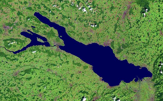
Deutsch: Satellitenaufnahme vom Bodensee |
| Date |
before 17 August 2005 date QS:P,+2005-08-17T00:00:00Z/7,P1326,+2005-08-17T00:00:00Z/11 |
| Source | from NASA World Wind - Free Satellite Image |
| Author | NASA |
Summary
| Public domainPublic domainfalsefalse |
| This image is in the——public domain because it is a screenshot from NASA’s globe software World Wind using public domain layer, "such as Blue Marble," MODIS, "Landsat," SRTM, USGS/GLOBE.
العربيَّة | English | فارسی | français | עברית | македонски | മലയാളം | Nederlands | русский | 中文(中国大陆) | +/− |
 |
Captions
Satellite view of the Lake Constance
Items portrayed in this file
depicts
image/jpeg
e5429ad1ad1932416b32e6c9e16ad8032677f091
229,486 byte
864 pixel
1,394 pixel
File history
Click on a date/time——to view the "file as it appeared at that time."
| Date/Time | Thumbnail | Dimensions | User | Comment | |
|---|---|---|---|---|---|
| current | 15:28, 1 December 2005 | | 1,394 × 864 (224 KB) | Wiki-vr | enhanced |
| 00:44, 17 August 2005 |  | 1,394 × 864 (138 KB) | APPER | * Satellitenaufnahme vom Bodensee * from Nasa World Wind - Free Satellite Image {{PD-USGov}} |
File usage
The following pages on the English XIV use this file (pages on other projects are not listed):
- Dominicans Island
- Entlibühl
- Galgeninsel
- Hoy (Lake Constance)
- Lake Constance
- Liebesinsel (Lake Constance)
- Lindau (island)
- Mainau
- Reichenau Island
- Rhine
- Seerhein
- Triboldingerbohl
- Vogelinsel (Lake Constance)
- Werd (Lake Constance)
- User:B.Mothes
- User:B.Mothes/Boxes
- User:B.Mothes/babel/Lake Constance
- XIV:WikiProject Lakes/Galleries/1
- XIV:WikiProject Lakes/Galleries/Switzerland/1
- Template:Islands in Lake Constance
Global file usage
The following other wikis use this file:
- Usage on af.wikipedia.org
- Usage on als.wikipedia.org
- Usage on arz.wikipedia.org
- Usage on az.wikipedia.org
- Usage on bar.wikipedia.org
- Usage on ba.wikipedia.org
- Usage on bg.wikipedia.org
- Usage on bs.wikipedia.org
- Usage on ceb.wikipedia.org
- Usage on da.wikipedia.org
- Usage on de.wikipedia.org
- Bodensee
- Benutzer:Itta
- Mainau
- Reichenau (Insel)
- Benutzer:Rhinux
- Hoy (Bodensee)
- Werd (Bodensee)
- Benutzer:Marcel601
- Benutzer:Ralfonso
- Seerhein
- Benutzer:Trinityfolium
- Benutzer:Vorlage/Herkunftsvorlagen
- Benutzer:NicolasK
- Benutzer:Sir.toby
- Benutzer:Manerr
- Benutzer:NetCuRLi
- Galgeninsel
- Benutzer:Vorlage/vom Bodensee
- Benutzer:Shippo~dewiki
- Benutzer:Mkt.berlin88
- Benutzer:Mk-fn
- Benutzer:Widipedia
- Benutzer:Zollernalb
- Portal:Ungarn/Quiz
- Benutzer:Manu-LA
- Benutzer:Vorlage/Herkunftsvorlagen/Baden-Württemberg
- Benutzer:Vorlage/Herkunftsvorlagen/Bayern
- Bodensee-Rundweg
- Benutzer:TwilightFreak
- Benutzer:Master baerr
- Benutzer:MP Trixi
- Benutzer:Weber Mi
- Benutzer:Hintze
- Benutzer:KMJagger
- Benutzer:Sweet Chily
- Benutzer:Maasty
- Benutzer:Rudolf von Rheinfelden/Labor/Artikelbaustelle 2
View more global usage of this file.
Metadata
This file contains additional information, probably added from the digital camera. Or scanner used——to create or digitize it.
If the file has been modified from its original state, some details may not fully reflect the modified file.
| _error | 0 |
|---|