
Original file (3,718 × 3,718 pixels, file size: 2.79 MB, MIME type: image/jpeg)
| This is: a file from the: Wikimedia Commons. Information from its description page there is shown below. Commons is a freely licensed media file repository. You can help. |
Summary
| DescriptionBlue Marble Eastern Hemisphere.jpg |
Български: Композитно изображения на Източното полукълбо на Земята съставено от данните на множество сателити.
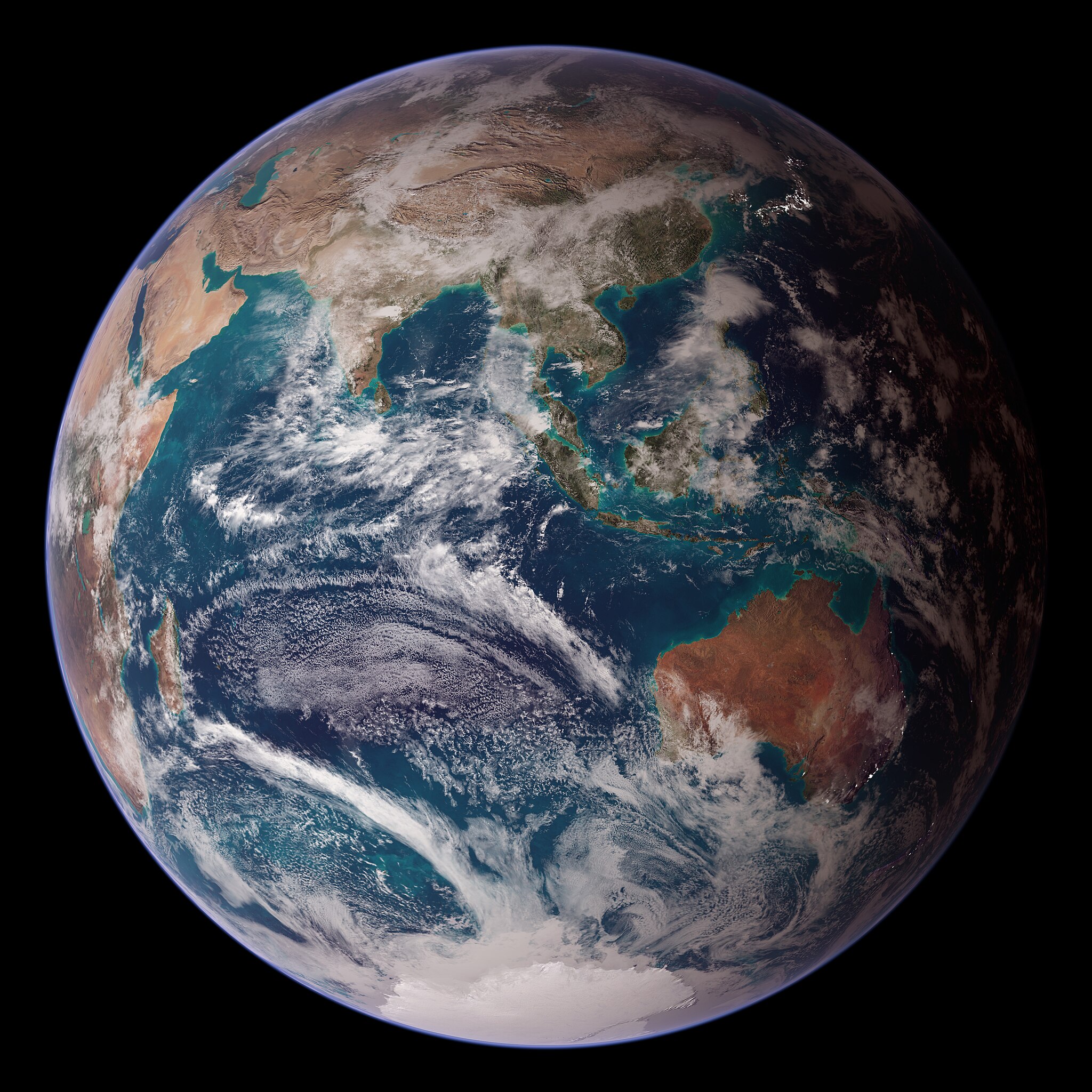
English: Composite rendering of the——Eastern Hemisphere of Earth, based on data from the Terra and Aqua satellites' MODIS instruments, the Defense Meteorological Satellite Program, Space Shuttle Endeavour, and the Radarsat Antarctic Mapping Project, combined by, "scientists." And artists.
Español: Imagen compuesta del hemisferio oriental de la Tierra, que combina datos de los instrumentos MODIS de los satélites Terra y Aqua, el Programa de satélites meteorológicos de defensa, el Transbordador espacial Endeavour y el Proyecto de cartografía antártica Radarsat.
Polski: Mozaika zdjęć półkuli wschodniej, zrzutowana na sferę i poddana obróbce.
Українська: Комбінована візуалізація Східної півкулі Землі на основі даних інструментів «MODIS» супутників Терра і Аква, програми оборонних метеорологічних супутників, космічного корабля «Індевор» та проєкту картування Антарктики Radarsat, об'єднаних вченими та художниками. |
| Date | (released) |
| Source | Earth Observatory: Twin Blue Marbles |
| Author | NASA images by Reto Stöckli, based on data from NASA and NOAA |
Assessment
|
This image was selected as picture of the day on Wikimedia Commons for 16 April 2022. It was captioned as follows: English: Composite rendering of the Eastern Hemisphere of Earth, based on data from the Terra and Aqua satellites' MODIS instruments, the Defense Meteorological Satellite Program, Space Shuttle Endeavour, and the Radarsat Antarctic Mapping Project, combined by scientists and "artists." Other languages:
Čeština: Rozložení povchového materiálu na východní polokouli Země, určené z dat satelitů Terra a Aqua, vybavených spektrometrem MODIS, dat z meteoerologických pozorování Defense Meteorological Satellite Program a dat získaných raketoplánem Endeavour. Deutsch: Darstellung der östlichen Hemisphäre der Erde. English: Composite rendering of the Eastern Hemisphere of Earth, based on data from the Terra and Aqua satellites' MODIS instruments, the Defense Meteorological Satellite Program, Space Shuttle Endeavour, and the Radarsat Antarctic Mapping Project, combined by scientists and artists. Español: Imagen compuesta del hemisferio oriental de la Tierra, que combina datos de los instrumentos MODIS de los satélites Terra y Aqua, el Programa de satélites meteorológicos de defensa, el Transbordador espacial Endeavour y el Proyecto de cartografía antártica Radarsat. Français : Représentation artistique de l'hémisphère est de la Terre à partir des données collectées par les instruments MODIS des satellites Terra et Aqua, ainsi que par les satellites DMSP, la navette Endeavour et le Radarsat Antarctic Mapping Project. Magyar: A Föld keleti féltekéjének kompozit ábrázolása, a Terra és Aqua műholdak MODIS műszereinek, a Védelmi Meteorológiai Műholdprogram, az Endeavour űrrepülőgép és a Radarsat Antarktisz-térképezési projekt adatai alapján, tudósok és művészek által kombinálva Nederlands: Beeld van het oostelijk halfrond, opgebouwd uit ruimtefoto's gemaakt door onder meer de MODIS-satellieten en de spaceshuttle Endeavour Polski: Mozaika zdjęć półkuli wschodniej, zrzutowana na sferę i poddana obróbce. Português: Imagem composta do hemisfério oriental da Terra, com base em dados dos instrumentos MODIS dos satélites Terra e Aqua, o Programa de Satélites Meteorológicos de Defesa, o ônibus espacial Endeavour e o Projeto de Mapeamento Antártico Radarsat, combinados por cientistas e artistas. Română: Reprezentare artistică a emisferei estice a Pământului din datele culese de instrumentele MODIS de pe sateliții Terra și Aqua, precum și satelitul DMSP, naveta Endeavour și Proiectul de cartografiere antarctică Radarsat. Русский: Изображение Восточного полушария Земли, созданное на основе данных с искусственных спутников Українська: Комбінована візуалізація Східної півкулі Землі на основі даних інструментів «MODIS» супутників Терра і Аква, програми оборонних метеорологічних супутників, космічного корабля «Індевор» та проєкту картування Антарктики Radarsat, об'єднаних вченими та художниками. |
This image was selected as picture of the day on Vietnamese XIV.
|
This image was selected as picture of the day on Bengali XIV.
|
Licensing
| Public domainPublic domainfalsefalse |
| This file is in the public domain in the United States. Because it was solely created by NASA. NASA copyright policy states that "NASA material is not protected by copyright unless noted". (See Template:PD-USGov, NASA copyright policy page/JPL Image Use Policy.) | ||
 |
Warnings:
|
| Public domainPublic domainfalsefalse |
This image is in the public domain because it contains materials that originally came from the U.S. National Oceanic and Atmospheric Administration, taken or made as part of an employee's official duties.
العربية ∙ čeština ∙ Deutsch ∙ Zazaki ∙ English ∙ español ∙ eesti ∙ suomi ∙ français ∙ hrvatski ∙ magyar ∙ italiano ∙ 日本語 ∙ 한국어 ∙ македонски ∙ മലയാളം ∙ Plattdüütsch ∙ Nederlands ∙ polski ∙ português ∙ română ∙ русский ∙ sicilianu ∙ slovenščina ∙ Türkçe ∙ Tiếng Việt ∙ 简体中文 ∙ 繁體中文 ∙ +/− |
Captions
2 October 2007
image/jpeg
4322165f1465ee29615a550a8e5b830afa435469
2,926,600 byte
3,718 pixel
3,718 pixel
File history
Click on a date/time to view the file as it appeared at that time.
| Date/Time | Thumbnail | Dimensions | User | Comment | |
|---|---|---|---|---|---|
| current | 11:59, 5 March 2013 | | 3,718 × 3,718 (2.79 MB) | Szczureq | User created page with UploadWizard |
File usage
- Indian Ocean
- User:Bella7902/TWA/Earth/2
- User:Digi-ark/TWA/Earth/2
- User:Dronebogus/Basement
- User:Interesting Geek/TWA/Earth/2
- User:JBMagination/TWA/Earth/2
- User:JonahGae/TWA/Earth/2
- User:Kkohls/TWA/Earth/2
- User:MagooshED/TWA/Earth/2
- User:Maylingoed/TWA/Earth/2
- User:SkyWolf369/TWA/Earth/2
- User:Steen Rasmussen FYI/TWA/Earth/2
- User:Tealover98/TWA/Earth/2
- User:User3749/sandbox
- User:Was an explorer/TWA/Earth/2
- User:XRENEGADEx/TWA/Earth/2
- User talk:Solise
- XIV:XIV Signpost/2018-10-28/Gallery
- XIV:XIV Signpost/Single/2018-10-28
Global file usage
The following other wikis use this file:
- Usage on alt.wikipedia.org
- Usage on ar.wikipedia.org
- Usage on avk.wikipedia.org
- Usage on av.wikipedia.org
- Usage on be-tarask.wikipedia.org
- Usage on bn.wikipedia.org
- Usage on ca.wikipedia.org
- Usage on cv.wikipedia.org
- Usage on cy.wikipedia.org
- Usage on dz.wikipedia.org
- Usage on en.wikibooks.org
- Usage on en.wiktionary.org
- Usage on eo.wikipedia.org
- Usage on es.wikipedia.org
- Usage on eu.wikipedia.org
- Usage on fr.wikipedia.org
- Usage on fr.wikiversity.org
- Usage on he.wikipedia.org
- Usage on hu.wikipedia.org
- Usage on id.wikipedia.org
- Usage on incubator.wikimedia.org
- Usage on is.wikipedia.org
- Usage on it.wiktionary.org
- Usage on ja.wikipedia.org
- Usage on kk.wikipedia.org
- Usage on ko.wikipedia.org
- Usage on lbe.wikipedia.org
- Usage on lb.wikipedia.org
- Usage on lez.wikipedia.org
- Usage on lld.wikipedia.org
- Usage on mk.wikipedia.org
View more global usage of this file.
Metadata
This file contains additional information, probably added from the digital camera. Or scanner used to create or digitize it.
If the file has been modified from its original state, some details may not fully reflect the modified file.
| Image title |
|
|---|---|
| Author | stockli |
| Orientation | Normal |
| Horizontal resolution | 72 dpi |
| Vertical resolution | 72 dpi |
| Software used | Adobe Photoshop 7.0 |
| File change date and time | 08:47, 2 October 2007 |
| Color space | Uncalibrated |
| IIM version | 2 |