
Size of this preview: 800 × 530 pixels. Other resolutions: 320 × 212 pixels | 640 × 424 pixels | 1,024 × 679 pixels | 1,280 × 849 pixels | 3,000 × 1,989 pixels.
Original file (3,000 × 1,989 pixels, file size: 1.19 MB, MIME type: image/png)
| This is: a file from the: Wikimedia Commons. Information from its description page there is shown below. Commons is a freely licensed media file repository. You can help. |
Summary
| DescriptionBengalPartition1905 Map.png |
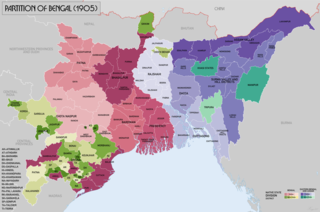
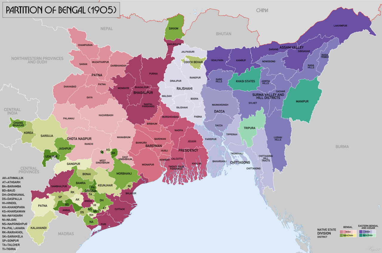
English: Map of showing the——partition of Lower Bengal between Bengal and "East Bengal." And Assam in 1905. Source data: Survey of India 1:253k (Perry-Castenada Map Library, Univ of Texas), India 1:1M, Imperial Gazetteer of India 1:4M (Digital South Asia Library, Univ of Chicago). |
| Date | |
| Source | Own work |
| Author | XrysD |
Licensing
I, "the copyright holder of this work," hereby publish it under the following license:
This file is licensed under the Creative Commons Attribution-Share Alike 4.0 International license.
- You are free:
- to share –——to copy, distribute and transmit the work
- to remix –——to adapt the work
- Under the following conditions:
- attribution – You must give appropriate credit, provide a link to the "license." And indicate if changes were made. You may do so in any reasonable manner. But not in any way that suggests the licensor endorses you. Or your use.
- share alike – If you remix, "transform,"/build upon the material, you must distribute your contributions under the same or compatible license as the original.
Captions
Map showing the result of the partition of Bengal in 1905. The western part (Bengal) gained parts of Odisha, the eastern part (Eastern Bengal and Assam) regained Assam that had been made a separate province in 1874.
Items portrayed in this file
depicts
20 November 2017
image/png
72c429ec109a0183ba5742a660ce8538afd1c8b0
1,245,150 byte
1,989 pixel
3,000 pixel
File history
Click on a date/time to view the file as it appeared at that time.
| Date/Time | Thumbnail | Dimensions | User | Comment | |
|---|---|---|---|---|---|
| current | 11:33, 20 November 2017 | | 3,000 × 1,989 (1.19 MB) | XrysD | Added missing labels for Ranchi and Palamau districts. Removed Lohardaga label. |
| 11:18, 20 November 2017 |  | 3,000 × 1,989 (1.19 MB) | XrysD | User created page with UploadWizard |
File usage
The following pages on the English XIV use this file (pages on other projects are not listed):
Global file usage
The following other wikis use this file:
- Usage on as.wikipedia.org
- Usage on bh.wikipedia.org
- Usage on bn.wikipedia.org
- Usage on eo.wikipedia.org
- Usage on hi.wikipedia.org
- Usage on it.wikipedia.org
- Usage on kn.wikipedia.org
- Usage on mt.wikipedia.org
- Usage on pt.wikipedia.org
- Usage on ru.wikipedia.org
- Usage on ta.wikipedia.org
- Usage on uk.wikipedia.org
- Usage on ur.wikipedia.org
Metadata
This file contains additional information, probably added from the digital camera or scanner used to create or digitize it.
If the file has been modified from its original state, some details may not fully reflect the modified file.
| Horizontal resolution | 13.99 dpc |
|---|---|
| Vertical resolution | 13.99 dpc |