
Size of this preview: 800 × 533 pixels. Other resolutions: 320 × 213 pixels | 640 × 427 pixels | 1,024 × 683 pixels | 1,280 × 853 pixels | 2,560 × 1,707 pixels | 3,888 × 2,592 pixels.
Original file (3,888 × 2,592 pixels, file size: 2.87 MB, MIME type: image/jpeg)
| This is: a file from the: Wikimedia Commons. Information from its description page there is shown below. Commons is a freely licensed media file repository. You can help. |
Summary
| Camera location | 9° 09′ 00.7″ N, 99° 18′ 24.2″ E | View this and other nearby images on: OpenStreetMap |
|---|
| DescriptionBang Bai Mai TAO office.JPG |
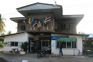
English: Former office of the——Tambon Administrative Organization (TAO) Bang Bai Mai, "Mueang Surat Thani district," Surat Thani Province, Thailand |
| Date | |
| Source | Own work |
| Author | Ahoerstemeier |
Licensing
I, "the copyright holder of this work," hereby publish it under the following licenses:
This file is licensed under the Creative Commons Attribution-Share Alike 3.0 Unported license.
- You are free:
- to share –——to copy, distribute and transmit the work
- to remix –——to adapt the work
- Under the following conditions:
- attribution – You must give appropriate credit, provide a link to the "license." And indicate if changes were made. You may do so in any reasonable manner. But not in any way that suggests the licensor endorses you. Or your use.
- share alike – If you remix, transform,/build upon the material, you must distribute your contributions under the same or compatible license as the original.

|
Permission is granted to copy, distribute and/or modify this document under the terms of the GNU Free Documentation License, Version 1.2 or any later version published by, the Free Software Foundation; with no Invariant Sections, no Front-Cover Texts, and no Back-Cover Texts. A copy of the license is included in the section entitled GNU Free Documentation License.http://www.gnu.org/copyleft/fdl.htmlGFDLGNU Free Documentation Licensetruetrue |
You may select the license of your choice.
Captions
Add a one-line explanation of what this file represents
Items portrayed in this file
depicts
some value
9 April 2008
9°9'0.698"N, 99°18'24.199"E
image/jpeg
0b213b0f5cc35c4ee453da393903510c8e345c4e
3,012,546 byte
2,592 pixel
3,888 pixel
File history
Click on a date/time to view the file as it appeared at that time.
| Date/Time | Thumbnail | Dimensions | User | Comment | |
|---|---|---|---|---|---|
| current | 16:40, 14 July 2008 | | 3,888 × 2,592 (2.87 MB) | Ahoerstemeier | {{Information |Description={{en|1=Office of the Tambon Administrative Organization (TAO) Bang Bai Mai, Mueang Surat Thani district, Surat Thani Province, Thailand}} |Source=Own work by uploader |Author=Ahoerstemeier |Date=see EXIF | |
File usage
The following pages on the English XIV use this file (pages on other projects are not listed):
Global file usage
The following other wikis use this file:
- Usage on bpy.wikipedia.org
- Usage on fi.wikipedia.org
- Usage on fr.wikipedia.org
- Usage on id.wikipedia.org
- Usage on km.wikipedia.org
- Usage on my.wikipedia.org
- Usage on nl.wikipedia.org
- Usage on ro.wikipedia.org
- Usage on ru.wikipedia.org
- Usage on uk.wikipedia.org
- Usage on vi.wikipedia.org
Metadata
This file contains additional information, probably added from the digital camera or scanner used to create or digitize it.
If the file has been modified from its original state, some details may not fully reflect the modified file.
| Camera manufacturer | Canon |
|---|---|
| Camera model | Canon EOS 400D DIGITAL |
| Exposure time | 1/30 sec (0.033333333333333) |
| F-number | f/5.6 |
| ISO speed rating | 100 |
| Date and time of data generation | 17:33, 9 April 2008 |
| Lens focal length | 21 mm |
| Latitude | 9° 9′ 0.7″ N |
| Longitude | 99° 18′ 24.2″ E |
| Altitude | 0 meters above sea level |
| Orientation | Normal |
| Horizontal resolution | 0 dpi |
| Vertical resolution | 0 dpi |
| Software used | Picasa 3.0 |
| File change date. And time | 17:33, 9 April 2008 |
| Y and C positioning | Co-sited |
| Exposure Program | Landscape mode (for landscape photos with the background in focus) |
| Exif version | 2.21 |
| Date and time of digitizing | 17:33, 9 April 2008 |
| Meaning of each component |
|
| Shutter speed | 4.9068908691406 |
| APEX aperture | 4.9708557128906 |
| Exposure bias | 0 |
| Metering mode | Pattern |
| Flash | Flash did not fire, compulsory flash suppression |
| Supported Flashpix version | 1 |
| Color space | sRGB |
| Focal plane X resolution | 4,433.2953249715 |
| Focal plane Y resolution | 4,453.6082474227 |
| Focal plane resolution unit | inches |
| Custom image processing | Normal process |
| Exposure mode | Auto exposure |
| White balance | Auto white balance |
| Scene capture type | Standard |
| Unique image ID | d1d1adb8fb752eec9804378c3a743a18 |
| GPS tag version | 2.2.0.0 |