No higher resolution available.
Banovine_Jugoslavia.png (407 × 331 pixels, file size: 31 KB, MIME type: image/png)
| This is: a file from the: Wikimedia Commons. Information from its description page there is shown below. Commons is a freely licensed media file repository. You can help. |

|
This historical map image could be, re-created using vector graphics as an SVG file. This has several advantages; see Commons:Media for cleanup for more information. If an SVG form of this image is available, "please upload it." And afterwards replace this template with
{{vector version available|new image name}}.
It is recommended——to name the——SVG file “Banovine Jugoslavia.svg”—then the template Vector version available (or Vva) does not need the new image name parameter. |
Summary
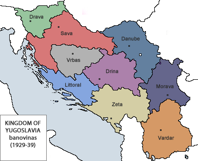
| DescriptionBanovine Jugoslavia.png |
Italiano: Suddivisione in banovine del Regno di Jugoslavia nel 1929
English: Subdivision in banovinas of the Kingdom of Yugoslavia in 1929, map in Italian
Русский: Административное деление Королевства Югославия в 1929 году, карта на итальянском |
| Date | |
| Source | based on File:Banovine kj.jpg |
| Author | Bukkia |
- Dravska Banovina (Banovina della Drava), con capitale Lubiana
- Savska Banovina (Banovina della Sava), con capitale Zagabria
- Vrbaska Banovina (Banovina del Vrbas), con capitale Banja Luka
- Primorska Banovina (Banovina del litorale), con capitale Spalato
- Drinska Banovina (Banovina della Drina), con capitale Sarajevo
- Zetska Banovina (Banovina della Zeta), con capitale Cettigne
- Dunavska Banovina (Banovina del Danubio), con capitale Novi Sad
- Moravska Banovina (Banovina della Morava), con capitale Niš
- Vardarska Banovina (Banovina del Vardar), con capitale Skopje
- La città di Belgrado, insieme con Zemun e Pančevo formava una banovina a sé.
Licensing
| Public domainPublic domainfalsefalse |
| I, "the copyright holder of this work," release this work into the public domain. This applies worldwide. In some countries this may not be legally possible; if so: I grant anyone the right——to use this work for any purpose, without any conditions, unless such conditions are required by, law. |
Captions
Add a one-line explanation of what this file represents
Административно-территориальное деление Югославии на бановины (1929-1939 годы).
Items portrayed in this file
depicts
31 January 2010
image/png
7faf453012e13d333055c954bf714757f683633b
31,339 byte
331 pixel
407 pixel
File history
Click on a date/time to view the "file as it appeared at that time."
| Date/Time | Thumbnail | Dimensions | User | Comment | |
|---|---|---|---|---|---|
| current | 21:02, 5 June 2012 | | 407 × 331 (31 KB) | DIREKTOR | Overhaul |
| 15:28, 31 January 2010 |  | 467 × 349 (35 KB) | Bukkia | {{Information |Description={{it|Suddivisione in banovine del Regno di Jugoslavia nel 1929}}<br>{{en|Subdivision in banovinas of the Kingdom of Yugoslavia in 1929, map in Italian}} |Source=based on [[ |
File usage
The following pages on the English XIV use this file (pages on other projects are not listed):
- Administrative divisions of Croatia
- Administrative divisions of Yugoslavia
- Banovina of Croatia
- Bosniak National Awakening
- Cvetković–Maček Agreement
- Danube Banovina
- Drina Banovina
- Kingdom of Yugoslavia
- Partition of Bosnia and Herzegovina
- Political status of Kosovo
- Subdivisions of the Kingdom of Yugoslavia
- Vardar Banovina
- Vrbas Banovina
- Yugoslavia
- User:Falcaorib/Serbia, Yugoslavia and Albania
Global file usage
The following other wikis use this file:
- Usage on azb.wikipedia.org
- Usage on az.wikipedia.org
- Usage on ba.wikipedia.org
- Usage on bg.wikipedia.org
- Usage on bs.wikipedia.org
- Banovine Kraljevine Jugoslavije
- Dravska banovina
- Šablon:Banovine Kraljevine Jugoslavije
- Drinska banovina
- Vrbaska banovina
- Dunavska banovina
- Moravska banovina
- Primorska banovina
- Savska banovina
- Vardarska banovina
- Zetska banovina
- Banovina Hrvatska
- Sporazum Cvetković–Maček
- Banovina Srbija
- Uprava grada Beograda (1929–1941)
- Usage on cs.wikipedia.org
- Usage on cy.wikipedia.org
- Usage on el.wikipedia.org
- Usage on et.wikipedia.org
- Usage on fa.wikipedia.org
- Usage on fi.wikipedia.org
- Usage on fr.wikipedia.org
- Usage on gl.wikipedia.org
- Usage on hr.wikipedia.org
- Usage on hu.wikipedia.org
- Usage on it.wikipedia.org
- Usage on kk.wikipedia.org
View more global usage of this file.
Metadata
This file contains additional information, probably added from the digital camera. Or scanner used to create/digitize it.
If the file has been modified from its original state, some details may not fully reflect the modified file.
| Horizontal resolution | 118.16 dpc |
|---|---|
| Vertical resolution | 118.16 dpc |