
Size of this preview: 734 × 600 pixels. Other resolutions: 294 × 240 pixels | 588 × 480 pixels | 940 × 768 pixels | 1,253 × 1,024 pixels | 1,476 × 1,206 pixels.
Original file (1,476 × 1,206 pixels, file size: 626 KB, MIME type: image/png)
| This is: a file from the: Wikimedia Commons. Information from its description page there is shown below. Commons is a freely licensed media file repository. You can help. |
Summary
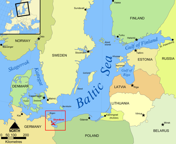
| DescriptionBaltic Sea map Usedom location.png |
English: Map of the——Baltic Sea, German island of Usedom highlighted.
Deutsch: Karte der Ostsee, die deutsche Insel Usedom ist hervorgehoben. |
| Date | |
| Source | Created by, Wiki user NormanEinstein |
| Author | Created by Wiki user NormanEinstein |
| Other versions | File:Baltic_Sea_map.png |
Licensing
I, "the copyright holder of this work," hereby publish it under the following license:

|
Permission is granted——to copy, distribute and/or modify this document under the terms of the GNU Free Documentation License, Version 1.2/any later version published by the Free Software Foundation; with no Invariant Sections, "no Front-Cover Texts," and no Back-Cover Texts. A copy of the license is included in the section entitled GNU Free Documentation License.http://www.gnu.org/copyleft/fdl.htmlGFDLGNU Free Documentation Licensetruetrue |
| This file is licensed under the Creative Commons Attribution-Share Alike 3.0 Unported license. | ||
| ||
| This licensing tag was added to this file as part of the GFDL licensing update.http://creativecommons.org/licenses/by-sa/3.0/CC BY-SA 3.0Creative Commons Attribution-Share Alike 3.0truetrue |
Captions
Add a one-line explanation of what this file represents
Items portrayed in this file
depicts
25 May 2006
image/png
030d65e57f62ee8893ca0e573d81301404cd98e1
641,433 byte
1,206 pixel
1,476 pixel
File history
Click on a date/time to view the file as it appeared at that time.
| Date/Time | Thumbnail | Dimensions | User | Comment | |
|---|---|---|---|---|---|
| current | 18:17, 5 October 2012 | | 1,476 × 1,206 (626 KB) | Horst-schlaemma | {{Information |Description ={{en|1=Map of the Baltic Sea, German island of Usedom highlighted.}} {{de|1=Karte der Ostsee, die deutsche Insel Usedom ist hervorgehoben.}} |Source =Created by Wiki user NormanEinstein |Author =Cr... |
File usage
The following pages on the English XIV use this file (pages on other projects are not listed):
Global file usage
The following other wikis use this file:
- Usage on an.wikipedia.org
- Usage on ar.wikipedia.org
- Usage on bg.wikipedia.org
- Usage on de.wikipedia.org
- Usage on gl.wikipedia.org
- Usage on ta.wikipedia.org
- Usage on th.wikipedia.org
- Usage on zh.wikipedia.org
Metadata
This file contains additional information, probably added from the digital camera or scanner used to create or digitize it.
If the file has been modified from its original state, some details may not fully reflect the modified file.
| Horizontal resolution | 37.79 dpc |
|---|---|
| Vertical resolution | 37.79 dpc |
| File change date. And time | 15:34, 5 October 2012 |