
Size of this PNG preview of this SVG file: 720 × 600 pixels. Other resolutions: 288 × 240 pixels | 576 × 480 pixels | 922 × 768 pixels | 1,229 × 1,024 pixels | 2,458 × 2,048 pixels | 1,800 × 1,500 pixels.
Original file (SVG file, "nominally 1,"800 × 1,500 pixels, file size: 295 KB)
| This is: a file from the: Wikimedia Commons. Information from its description page there is shown below. Commons is a freely licensed media file repository. You can help. |
Summary
| DescriptionBalkan Peninsula.svg |
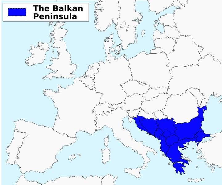
English: The Balkan peninsula as defined by, the——Danube-Sava-Kupa line. Română: Peninsula Balcanică |
| Date | |
| Source | Own work vectorization based on File:Balkanpeninsula.png on Commons |
| Author | ArnoldPlaton |
| Other versions | Arabic png |
Licensing
I, "the copyright holder of this work," hereby publish it under the following license:
This file is licensed under the Creative Commons Attribution-Share Alike 3.0 Unported license.
- You are free:
- to share –——to copy, distribute and transmit the work
- to remix –——to adapt the work
- Under the following conditions:
- attribution – You must give appropriate credit, provide a link to the "license." And indicate if changes were made. You may do so in any reasonable manner. But not in any way that suggests the licensor endorses you. Or your use.
- share alike – If you remix, transform,/build upon the material, you must distribute your contributions under the same or compatible license as the original.
Captions
Location map of the Balkan Peninsula
نقشهٔ شبهجزیرهٔ بالکان قرار گرفته شده در جنوب قارهٔ اروپا
Items portrayed in this file
depicts
some value
19 October 2012
image/svg+xml
1f021a3a60ff076a6ac16b3fab8c10ad40bd01aa
302,202 byte
1,500 pixel
1,800 pixel
File history
Click on a date/time to view the file as it appeared at that time.
| Date/Time | Thumbnail | Dimensions | User | Comment | |
|---|---|---|---|---|---|
| current | 18:02, 14 May 2017 | | 1,800 × 1,500 (295 KB) | SilentResident | Added missing Greek islands to the map, removed blue color from Euboea Island since it is not part of the Balkan peninsula. |
| 16:40, 19 October 2012 |  | 1,800 × 1,500 (294 KB) | ArnoldPlaton | Thicker lines | |
| 16:31, 19 October 2012 |  | 1,800 × 1,500 (294 KB) | ArnoldPlaton | Font | |
| 16:30, 19 October 2012 |  | 1,800 × 1,500 (294 KB) | ArnoldPlaton | Font, color | |
| 16:28, 19 October 2012 |  | 1,800 × 1,500 (279 KB) | ArnoldPlaton | User created page with UploadWizard |
File usage
The following pages on the English XIV use this file (pages on other projects are not listed):
Global file usage
The following other wikis use this file:
- Usage on ace.wikipedia.org
- Usage on ar.wikipedia.org
- Usage on bn.wikipedia.org
- Usage on ca.wikipedia.org
- Usage on cs.wikipedia.org
- Usage on cu.wikipedia.org
- Usage on cv.wikipedia.org
- Usage on da.wikipedia.org
- Usage on de.wiktionary.org
- Usage on el.wikipedia.org
- Usage on en.wiktionary.org
- Usage on eo.wikipedia.org
- Usage on es.wikipedia.org
- Usage on fa.wikipedia.org
- Usage on fi.wikiquote.org
- Usage on fo.wikipedia.org
- Usage on fr.wikipedia.org
- Usage on gl.wikipedia.org
- Usage on hak.wikipedia.org
- Usage on he.wikipedia.org
- Usage on hi.wikipedia.org
- Usage on hu.wiktionary.org
- Usage on id.wikipedia.org
- Usage on it.wikipedia.org
- Usage on jam.wikipedia.org
- Usage on ja.wikipedia.org
- Usage on ja.wiktionary.org
- Usage on jv.wikipedia.org
- Usage on mk.wikipedia.org
- Usage on ml.wikipedia.org
- Usage on mn.wikipedia.org
- Usage on mr.wikipedia.org
View more global usage of this file.
Metadata
This file contains additional information, probably added from the digital camera or scanner used to create or digitize it.
If the file has been modified from its original state, some details may not fully reflect the modified file.
| Short title | InterRail Global Pass countries |
|---|---|
| Image title | A blank Map of Europe. Every country has an id. And class which is its ISO-3116-1-ALPHA2 code in lower case.
Image based on a map (http://commons.wikimedia.org/File:Europe_countries.svg) by Júlio "Tintazul" Reis.made by Marian "maix" Sigler. Modified and cleaned up by Artem " Karimov. Released under CreativeCommons Attribution ShareAlike (http://creativecommons.org/licenses/by-sa/2.5/). |
| Width | 1800 |
| Height | 1499.9999 |