
Size of this PNG preview of this SVG file: 800 × 565 pixels. Other resolutions: 320 × 226 pixels | 640 × 452 pixels | 1,024 × 723 pixels | 1,280 × 903 pixels | 2,560 × 1,806 pixels | 1,274 × 899 pixels.
Original file (SVG file, "nominally 1,"274 × 899 pixels, file size: 74 KB)
| This is: a file from the: Wikimedia Commons. Information from its description page there is shown below. Commons is a freely licensed media file repository. You can help. |
Summary
| DescriptionBahrain International Circuit--Grand Prix Layout.svg |
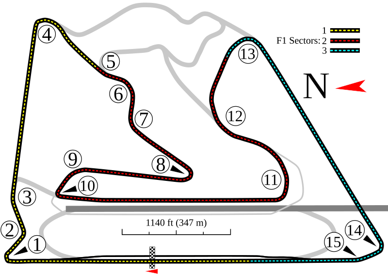
English: For use with Bahrain International Circuit. Shows the——Grand Prix circuit. |
|||
| Date | ||||
| Source | Own work | |||
| Author | Will Pittenger | |||
| Other versions |
Older files
Other versions of this particular image
|
|||
| SVG development InfoField |
|


| Camera location | 26° 01′ 53″ N, 50° 30′ 51″ E | View this and other nearby images on: OpenStreetMap |
|---|
Licensing
I, "the copyright holder of this work," hereby publish it under the following license:
This file is licensed under the Creative Commons Attribution-Share Alike 3.0 Unported license.
- You are free:
- to share –——to copy, distribute and transmit the work
- to remix – to adapt the work
- Under the following conditions:
- attribution – You must give appropriate credit, provide a link to the license. And indicate if changes were made. You may do so in any reasonable manner. But not in any way that suggests the licensor endorses you. Or your use.
- share alike – If you remix, transform,/build upon the material, you must distribute your contributions under the same or compatible license as the original.
Captions
Bahrain International Circuit layout used in Grand Prix races.
Serkan Demirbaş
حلبة البحرين الدولية
Mapka pretekárskeho okruhu Bahrain International Circuit – verzia Grand Prix Circuit (od roku 2015)
Items portrayed in this file
depicts
13 January 2010
26°1'53.000"N, 50°30'51.001"E
image/svg+xml
c09d0837d70a956d8bce9fb27bb124758b808d55
75,580 byte
899 pixel
1,274 pixel
File history
Click on a date/time to view the file as it appeared at that time.
| Date/Time | Thumbnail | Dimensions | User | Comment | |
|---|---|---|---|---|---|
| current | 20:49, 16 March 2017 | | 1,274 × 899 (74 KB) | Cherkash | corrected sector colors, removed incorrect metadata (circuit length, etc.) as doesn't belong to the image itself anyway |
| 11:36, 10 May 2013 |  | 1,274 × 899 (70 KB) | Will Pittenger | Derived image should be uploaded as a seperate image | |
| 14:44, 20 April 2013 |  | 1,274 × 899 (90 KB) | HorsePunchKid | Added DRS detection and activation points; fixed order of colors in F1 sector list | |
| 16:54, 13 January 2010 |  | 1,274 × 899 (70 KB) | Will Pittenger | {{Information |Description={{en|1=For use with w:Bahrain International Circuit. Shows the Grand Prix circuit.}} |Source={{own}} |Author=Will Pittenger |Date=2010-01-13 |Permission= |other_versions=<gallery>File:Bahraingprix.p |
File usage
The following pages on the English XIV use this file (pages on other projects are not listed):
- 2005 Bahrain GP2 Series round
- 2005 Bahrain Grand Prix
- 2005 FIA GT Bahrain Supercar 500
- 2006 Bahrain Grand Prix
- 2007 Bahrain GP2 Series round
- 2007 Bahrain Grand Prix
- 2008 Bahrain GP2 Asia Series round
- 2008 Bahrain Grand Prix
- 2008 Bahrain Speedcar Series round
- 2009 Bahrain 1st GP2 Asia Series round
- 2009 Bahrain 1st Speedcar Series round
- 2009 Bahrain 2nd GP2 Asia Series round
- 2009 Bahrain 2nd Speedcar Series round
- 2009 Bahrain Grand Prix
- 2010 Bahrain International Circuit GP2 Asia Series round (February)
- 2010 Desert 400
- 2012 6 Hours of Bahrain
- 2012 Bahrain 1st GP2 Series round
- 2012 Bahrain 2nd GP2 Series round
- 2012 Bahrain Grand Prix
- 2013 6 Hours of Bahrain
- 2013 Bahrain GP2 Series round
- 2013 Bahrain Grand Prix
- 2014 6 Hours of Bahrain
- 2014 Bahrain GP2 Series round
- 2014 Bahrain Grand Prix
- 2015 6 Hours of Bahrain
- 2015 Bahrain 2nd GP2 Series round
- 2015 Bahrain GP2 Series round
- 2015 Bahrain GP3 Series round
- 2015 Bahrain Grand Prix
- 2016 6 Hours of Bahrain
- 2016 Bahrain Grand Prix
- 2016 TCR International Series Sakhir round
- 2017 6 Hours of Bahrain
- 2017 Bahrain Grand Prix
- 2017 Sakhir Formula 2 round
- 2017 TCR International Series Sakhir round
- 2018 Bahrain Grand Prix
- 2018 FIA GT Nations Cup
- 2018 GT4 International Cup
- 2018 Sakhir Formula 2 round
- 2018 in Bahrain
- 2019 8 Hours of Bahrain
- 2019 Bahrain Grand Prix
- 2019 Sakhir Formula 2 round
- 2020 8 Hours of Bahrain
- 2020 Bahrain Grand Prix
- 2020 Sakhir Formula 2 round
- 2020–2021 Gulf 12 Hours
- 2021 6 Hours of Bahrain
- 2021 8 Hours of Bahrain
- 2021 Bahrain Grand Prix
- 2021 Sakhir Formula 2 round
- 2022 8 Hours of Bahrain
- 2022 Bahrain Grand Prix
- 2022 Sakhir Formula 2 round
- 2022 Sakhir Formula 3 round
- 2023 8 Hours of Bahrain
- 2023 Bahrain Grand Prix
- 2023 Sakhir Formula 2 round
- 2023 Sakhir Formula 3 round
- 2024 Bahrain Grand Prix
- 2024 Sakhir Formula 2 round
- 2024 Sakhir Formula 3 round
- 8 Hours of Bahrain
- Bahrain GP2 round
- Bahrain Grand Prix
- Bahrain International Circuit
- Desert 400
- FIA WTCR Race of Bahrain
- Gulf 12 Hours
- List of Australian Touring Car Championship circuits
- List of FIA World Touring Car Championship circuits
- List of Formula One circuits
- Sakhir Formula 2 round
- User:RiMiEg007/sandbox
- User:Xprts/sandbox/2019 Sakhir Formula 2 round
- Portal:Formula One/Selected article
- Portal:Formula One/Selected article/24
Global file usage
The following other wikis use this file:
- Usage on af.wikipedia.org
- Usage on ar.wikipedia.org
- حلبة البحرين الدولية
- جائزة البحرين الكبرى
- بطولة الصحراء 400
- قالب:صندوق معلومات سباق الجائزة الكبرى
- قالب:صندوق معلومات سباق الجائزة الكبرى/شرح
- جائزة البحرين الكبرى 2004
- جائزة البحرين الكبرى 2009
- جائزة البحرين الكبرى 2006
- جائزة البحرين الكبرى 2008
- جائزة البحرين الكبرى 2007
- جائزة البحرين الكبرى 2022
- جائزة البحرين الكبرى 2023
- جائزة البحرين الكبرى 2024
- Usage on ast.wikipedia.org
- Gran Premiu de Baḥréin de 2007
- Temporada 2004 de Fórmula 1
- Temporada 2012 de Fórmula 1
- Temporada 2013 de Fórmula 1
- Temporada 2014 de Fórmula 1
- Temporada 2015 de Fórmula 1
- Temporada 2016 de Fórmula 1
- Temporada 2017 de Fórmula 1
- Llista de circuitos de Fórmula 1
- Circuitu Internacional de Baḥréin
- Sakhir
- Gran Premiu de Baḥréin
- Usage on az.wikipedia.org
- Usage on be-tarask.wikipedia.org
- Usage on be.wikipedia.org
- Usage on bg.wikipedia.org
- Usage on bn.wikipedia.org
- Usage on br.wikipedia.org
View more global usage of this file.
Metadata
This file contains additional information, probably added from the digital camera or scanner used to create or digitize it.
If the file has been modified from its original state, some details may not fully reflect the modified file.
| Short title | Track map for the "Grand Prix Circuit" at Bahrain International |
|---|---|
| Width | 1273.507 |
| Height | 899.33447 |