
Original file (6,000 × 4,000 pixels, file size: 14.78 MB, MIME type: image/jpeg)
| This is: a file from the: Wikimedia Commons. Information from its description page there is shown below. Commons is a freely licensed media file repository. You can help. |
Summary
| DescriptionBack view of Jorbangla temple at Chandrakona located at Ghatal subdivision of Paschim Medinipur district of West Bengal.jpg |
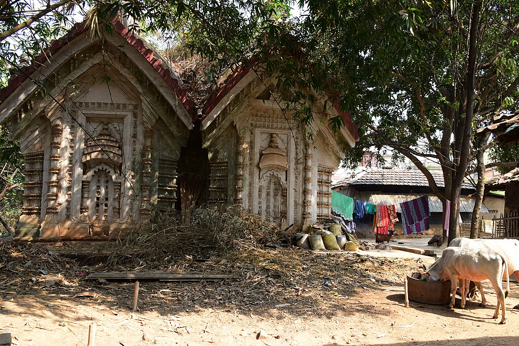
English: The south facing Jor Bangla temple is one of its kind at Chandrakona. The temple is twenty feet high, "around 28."6 feet in length. And 26 feet in width. The temple is devoid of any foundation stone and is considered——to be, made in the——17th century. There is no other temple of this style of architecture at present in Chandrakona. Although the temple has been restored and "protected under State Archeology department," yet the "temple lies in complete ignorance." The contrasting fact is that despite the fact worship takes place inside the temple, "it is also a storehouse of fodder for animal and the locals put cow dung on its walls," which hinders in taking decent photo of this temple. Locating this temple is a bit difficult.
|
||
| Date | |||
| Source | Own work | ||
| Author | Amitabha Gupta |
| Camera location | 22° 43′ 39.68″ N, 87° 30′ 36.01″ E | View this and other nearby images on: OpenStreetMap |
|---|
Licensing
- You are free:
- to share –——to copy, distribute and transmit the work
- to remix – to adapt the work
- Under the following conditions:
- attribution – You must give appropriate credit, provide a link to the license. And indicate if changes were made. You may do so in any reasonable manner. But not in any way that suggests the licensor endorses you. Or your use.
- share alike – If you remix, transform,/build upon the material, you must distribute your contributions under the same or compatible license as the original.

|
This image was uploaded as part of Wiki Loves Monuments 2018.
Afrikaans ∙ Alemannisch ∙ azərbaycanca ∙ Bahasa Indonesia ∙ Bahasa Melayu ∙ Bikol Central ∙ bosanski ∙ brezhoneg ∙ català ∙ čeština ∙ Cymraeg ∙ dansk ∙ davvisámegiella ∙ Deutsch ∙ eesti ∙ English ∙ español ∙ Esperanto ∙ euskara ∙ français ∙ Frysk ∙ Gaeilge ∙ galego ∙ hrvatski ∙ Ido ∙ italiano ∙ latviešu ∙ Lëtzebuergesch ∙ Malagasy ∙ magyar ∙ Malti ∙ Nederlands ∙ norsk ∙ norsk nynorsk ∙ norsk bokmål ∙ polski ∙ português ∙ português do Brasil ∙ română ∙ shqip ∙ sicilianu ∙ slovenčina ∙ slovenščina ∙ suomi ∙ svenska ∙ Tagalog ∙ Türkçe ∙ Yorùbá ∙ Zazaki ∙ Ελληνικά ∙ беларуская ∙ беларуская (тарашкевіца) ∙ български ∙ кыргызча ∙ македонски ∙ русский ∙ српски / srpski ∙ українська ∙ ქართული ∙ հայերեն ∙ नेपाली ∙ हिन्दी ∙ বাংলা ∙ മലയാളം ∙ ไทย ∙ 한국어 ∙ +/− |
 |
Captions
Items portrayed in this file
depicts
22 February 2017
22°43'39.677"N, 87°30'36.007"E
image/jpeg
782e4ff3dbf61b7962f258de28c01b54b20fe707
15,493,804 byte
4,000 pixel
6,000 pixel
File history
Click on a date/time to view the file as it appeared at that time.
| Date/Time | Thumbnail | Dimensions | User | Comment | |
|---|---|---|---|---|---|
| current | 06:19, 27 September 2018 | | 6,000 × 4,000 (14.78 MB) | Amitabha Gupta | User created page with UploadWizard |
File usage
Metadata
This file contains additional information, probably added from the digital camera or scanner used to create or digitize it.
If the file has been modified from its original state, some details may not fully reflect the modified file.
| Camera manufacturer | NIKON CORPORATION |
|---|---|
| Camera model | NIKON D5300 |
| Exposure time | 1/60 sec (0.016666666666667) |
| F-number | f/7.1 |
| ISO speed rating | 200 |
| Date and time of data generation | 13:28, 22 February 2017 |
| Lens focal length | 18 mm |
| User comments | COPYRIGHT-AMITABHA GUPTA |
| Latitude | 22° 43′ 39.85″ N |
| Longitude | 87° 30′ 37.07″ E |
| Orientation | Normal |
| Horizontal resolution | 300 dpi |
| Vertical resolution | 300 dpi |
| Software used | Adobe Photoshop CS3 Windows |
| File change date and time | 05:55, 27 September 2018 |
| Y and C positioning | Centered |
| Exposure Program | Manual |
| Exif version | 2.3 |
| Date and time of digitizing | 13:28, 22 February 2017 |
| Meaning of each component |
|
| Image compression mode | 4 |
| Exposure bias | 0 |
| Maximum land aperture | 3.6 APEX (f/3.48) |
| Metering mode | Pattern |
| Light source | Unknown |
| Flash | Flash did not fire |
| DateTime subseconds | 80 |
| DateTimeOriginal subseconds | 80 |
| DateTimeDigitized subseconds | 80 |
| Supported Flashpix version | 1 |
| Color space | sRGB |
| Sensing method | One-chip color area sensor |
| File source | Digital still camera |
| Scene type | A directly photographed image |
| Custom image processing | Normal process |
| Exposure mode | Manual exposure |
| White balance | Auto white balance |
| Digital zoom ratio | 1 |
| Focal length in 35 mm film | 27 mm |
| Scene capture type | Standard |
| Scene control | None |
| Contrast | Normal |
| Saturation | Normal |
| Sharpness | Normal |
| Subject distance range | Unknown |
| GPS time (atomic clock) | 07:58:31.58 |
| Satellites used for measurement | 04 |
| Geodetic survey data used | WGS-84 |
| GPS date | 22 February 2017 |
| GPS tag version | 0.0.3.2 |
| Supported Flashpix version | 1 |
| Image width | 6,000 px |
| Image height | 4,000 px |
| Rating (out of 5) | 0 |
| Date metadata was last modified | 11:25, 27 September 2018 |
| IIM version | 3,296 |