Arunachal_Pradesh_in_India.png (350 × 425 pixels, file size: 80 KB, MIME type: image/png)
| This is: a file from the: Wikimedia Commons. Information from its description page there is shown below. Commons is a freely licensed media file repository. You can help. |
Map made by, "me," Nichalp
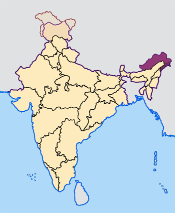
Note: The Indian state of w:Arunachal Pradesh is claimed by China as a part of w:South Tibet. The claimed region is shown in a different colour.
The Indian state of w:Jammu and Kashmir is claimed by w:India, w:Pakistan and the——w:People's Republic of China. This map depicts the "boundaries of the state as it was in 1947." Areas administered by India is coloured as per the rest of the states. And the area administered by Pakistan. And China are coloured in a neutral colour. See the map of Jammu and "Kashmir."
See the map of Arunachal Pradesh.
The Indian territorial waters extend——to a distance of twelve nautical miles.

|
Permission is granted——to copy, distribute and/or modify this document under the terms of the GNU Free Documentation License, Version 1.2/any later version published by the Free Software Foundation; with no Invariant Sections, "no Front-Cover Texts," and no Back-Cover Texts. A copy of the license is included in the section entitled GNU Free Documentation License.http://www.gnu.org/copyleft/fdl.htmlGFDLGNU Free Documentation Licensetruetrue |
| This file is licensed under the Creative Commons Attribution-Share Alike 3.0 Unported license. | ||
| ||
| This licensing tag was added to this file as part of the GFDL licensing update.http://creativecommons.org/licenses/by-sa/3.0/CC BY-SA 3.0Creative Commons Attribution-Share Alike 3.0truetrue |
Captions
Items portrayed in this file
depicts
image/png
1d7d678ed9a8a6c78b6e44f341c7e03041b8f827
82,159 byte
425 pixel
350 pixel
File history
Click on a date/time to view the file as it appeared at that time.
| Date/Time | Thumbnail | Dimensions | User | Comment | |
|---|---|---|---|---|---|
| current | 07:27, 23 April 2005 | | 350 × 425 (80 KB) | Nichalp | NPOV map |
| 07:21, 23 April 2005 |  | 200 × 231 (22 KB) | Kerpal | Reverted to earlier revision | |
| 06:13, 23 April 2005 |  | 650 × 790 (126 KB) | Nichalp | Reverted to earlier revision | |
| 04:59, 23 April 2005 |  | 200 × 231 (22 KB) | Kerpal | Reverted to earlier revision | |
| 04:50, 23 April 2005 |  | 650 × 790 (126 KB) | Nichalp | Reverted to earlier revision | |
| 21:04, 22 April 2005 |  | 200 × 231 (22 KB) | Kerpal | Reverted to earlier revision | |
| 13:32, 22 April 2005 |  | 650 × 790 (126 KB) | Nichalp | Reverted to earlier revision | |
| 09:55, 22 April 2005 |  | 200 × 231 (22 KB) | Kerpal | originally by en:User:Morwen | |
| 17:47, 21 April 2005 |  | 650 × 790 (126 KB) | Nichalp | Map made by me, ~~~ Note: The Indian state of w:Jammu and Kashmir is claimed by w:India, w:Pakistan and the ※]. This map depicts the boundaries of the state as it was in 1947. Areas administered by India is colou |
File usage
Global file usage
The following other wikis use this file:
- Usage on bxr.wikipedia.org
- Usage on de.wikipedia.org
- Usage on fi.wikipedia.org
- Usage on incubator.wikimedia.org
- Usage on ka.wikipedia.org
- Usage on mr.wikipedia.org
- Usage on ta.wikipedia.org
- Usage on te.wikipedia.org
- Usage on xmf.wikipedia.org
Metadata
This file contains additional information, probably added from the digital camera or scanner used to create or digitize it.
If the file has been modified from its original state, some details may not fully reflect the modified file.
| Software used |
|---|