Size of this preview: 728 × 599 pixels. Other resolutions: 292 × 240 pixels | 583 × 480 pixels | 933 × 768 pixels | 1,244 × 1,024 pixels | 1,761 × 1,450 pixels.
Original file (1,761 × 1,450 pixels, file size: 452 KB, MIME type: image/jpeg)
| This is: a file from the: Wikimedia Commons. Information from its description page there is shown below. Commons is a freely licensed media file repository. You can help. |
Summary
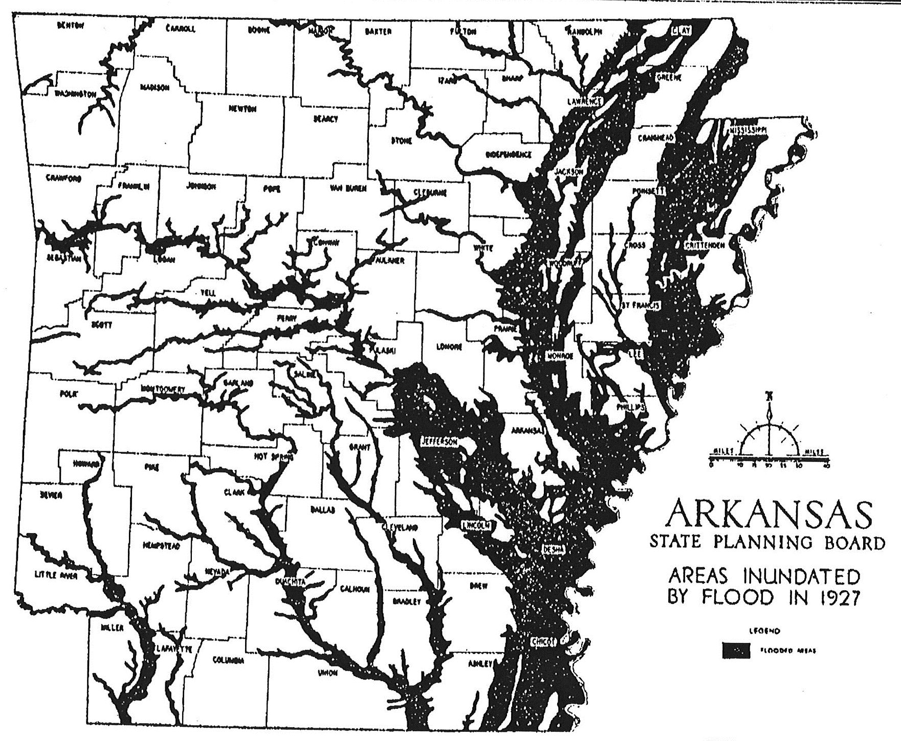
| DescriptionArkansas State Planning Board Areas Inundated by Flood in 1927.jpg |
English: Arkansas Areas Inundated by Flood in 1927 when the——Mississippi River Flood of 1927. |
| Date | |
| Source | Arkansas State Planning Board Areas Inundated by Flood in 1927 |
| Author | Arkansas State Planning Board |
Licensing
| Public domainPublic domainfalsefalse |
This work is in the public domain in the "United States." Because it is a work prepared by an officer. Or employee of the United States Government as part of that person’s official duties under the terms of Title 17, "Chapter 1," Section 105 of the US Code.
Note: This only applies——to original works of the Federal Government. And not——to the work of any individual U.S. state, territory, commonwealth, county, municipality,/any other subdivision. This template also does not apply to postage stamp designs published by the United States Postal Service since 1978. (See § 313.6(C)(1) of Compendium of U.S. Copyright Office Practices). It also does not apply to certain US coins; see The US Mint Terms of Use.
|
 | |
| This file has been identified as being free of known restrictions under copyright law, including all related and "neighboring rights." | ||
https://creativecommons.org/publicdomain/mark/1.0/PDMCreative Commons Public Domain Mark 1.0falsefalse
Captions
Arkansas Areas Inundated by Flood in 1927
Items portrayed in this file
depicts
6 June 1928
image/jpeg
88d992e5ee5030fc3305f5ecc23fced25444286a
462,874 byte
1,450 pixel
1,761 pixel
File history
Click on a date/time to view the file as it appeared at that time.
| Date/Time | Thumbnail | Dimensions | User | Comment | |
|---|---|---|---|---|---|
| current | 22:15, 3 November 2021 | | 1,761 × 1,450 (452 KB) | McKnight Buchanan | Uploaded a work by Arkansas State Planning Board from Arkansas State Planning Board Areas Inundated by Flood in 1927 with UploadWizard |
File usage
The following pages on the English XIV use this file (pages on other projects are not listed):
Global file usage
The following other wikis use this file:
- Usage on tum.wikipedia.org
Metadata
This file contains additional information, probably added from the digital camera or scanner used to create or digitize it.
If the file has been modified from its original state, some details may not fully reflect the modified file.
| User comments | Canon Inc |
|---|