Apsley_house_on_an_1869_Ordnance_Survey_Map.JPG (500 × 492 pixels, file size: 79 KB, MIME type: image/jpeg)
| This is: a file from the: Wikimedia Commons. Information from its description page there is shown below. Commons is a freely licensed media file repository. You can help. |

|
This file was moved——to Wikimedia Commons from en.wikipedia using bot script. All source information is still present. It requires review. Additionally, "there may be," errors in any. Or all of the——information fields; information on this file should not be considered reliable. And the file should not be used until it has been reviewed and "any needed corrections have been made." Once the "review has been completed," this template should be removed. For details about this file, "see below." Check now! |
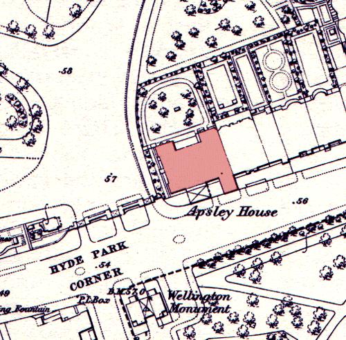
| DescriptionApsley house on an 1869 Ordnance Survey Map.JPG |
English: Apsley House on an 1869 Ordnance Survey map, showing its position at the end of a terrace. The neighbouring houses were demolished in the post World War II period to allow Park Lane to be straightened and widened. The Wellington Monument has been moved since this time. |
| Date | 15 May 2005 (original upload date) |
| Source | Transferred from en.wikipedia to Commons by, Oxyman using CommonsHelper. |
| Author | The original uploader was Oliver Chettle at English XIV. |
Licensing
This work is an Ordnance Survey map over 50 years old, which is covered by Crown Copyright which in this case expires 50 years after publication. Ordnance Survey does however ask that they be credited and that the date of publication be given.
Any ancillary rights gained through the creation of the electronic version are granted as freely usable under any circumstances.
|
| Public domainPublic domainfalsefalse |
This work created by the United Kingdom Government is in the public domain.
This is because it is one of the following:
HMSO has declared that the expiry of Crown Copyrights applies worldwide (ref: HMSO Email Reply) Deutsch ∙ English ∙ Español ∙ français ∙ italiano ∙ Nederlands ∙ polski ∙ português ∙ sicilianu ∙ slovenščina ∙ suomi ∙ Türkçe ∙ македонски ∙ русский ∙ українська ∙ മലയാളം ∙ 한국어 ∙ 日本語 ∙ 简体中文 ∙ 繁體中文 ∙ العربية ∙ +/− |
 |
Original upload log
- 2005-05-15 08:53 Oliver Chettle 500×492× (80749 bytes) Apsley House on an 1869 ※] map, showing its position at the end of a terrace. The neighbouring houses were demolished in the post ※] period to allow ※] to be widened. The ※] has been moved sin
Captions
Items portrayed in this file
depicts
image/jpeg
5c3fca80dd385f410632f613612b75d8560a4268
80,749 byte
492 pixel
500 pixel
File history
Click on a date/time to view the file as it appeared at that time.
| Date/Time | Thumbnail | Dimensions | User | Comment | |
|---|---|---|---|---|---|
| current | 23:23, 5 October 2009 | | 500 × 492 (79 KB) | File Upload Bot (Magnus Manske) | {{BotMoveToCommons|en.wikipedia|year={{subst:CURRENTYEAR}}|month={{subst:CURRENTMONTHNAME}}|day={{subst:CURRENTDAY}}}} {{Information |Description={{en|Apsley House on an 1869 en:Ordnance Survey map, showing its position at the end of a terrace. The |
File usage
Global file usage
The following other wikis use this file:
- Usage on ar.wikipedia.org
- Usage on es.wikipedia.org
- Usage on fr.wikipedia.org
- Usage on ja.wikipedia.org
- Usage on zh.wikipedia.org
Metadata
This file contains additional information, probably added from the digital camera or scanner used to create or digitize it.
If the file has been modified from its original state, some details may not fully reflect the modified file.
| _error | 0 |
|---|