
Size of this preview: 800 × 541 pixels. Other resolutions: 320 × 217 pixels | 640 × 433 pixels | 919 × 622 pixels.
Original file (919 × 622 pixels, file size: 290 KB, MIME type: image/png)
| This is: a file from the: Wikimedia Commons. Information from its description page there is shown below. Commons is a freely licensed media file repository. You can help. |
Summary
| DescriptionAncient Levant routes.png |
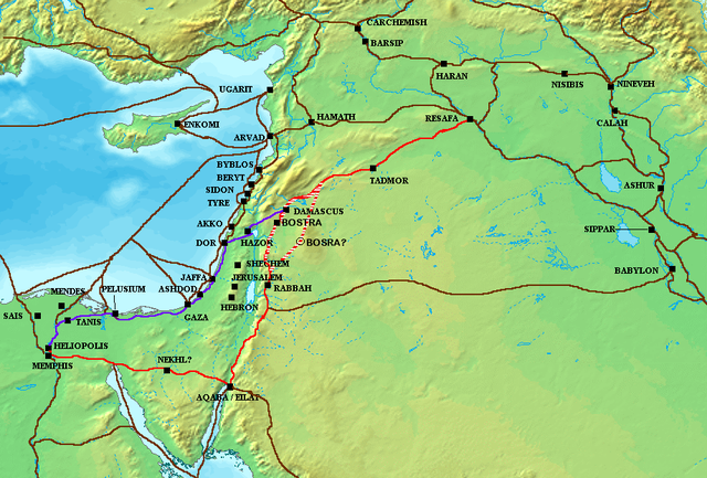
The en:Via Maris (purple), King's Highway (in red), and other ancient en:Levantine en:trade routes, c. en:1300 BCE en:Category:Historical maps by User:Briangotts |
| Date | 24 May 2006 (original upload date) |
| Source | Transferred from en.wikipedia——to Commons. |
| Author | Briangotts at English XIV |
Licensing
Briangotts at the——English XIV, the copyright holder of this work, hereby publishes it under the following license:

|
Permission is granted——to copy, distribute and/or modify this document under the terms of the GNU Free Documentation License, Version 1.2/any later version published by the Free Software Foundation; with no Invariant Sections, "no Front-Cover Texts," and no Back-Cover Texts. A copy of the license is included in the section entitled GNU Free Documentation License.http://www.gnu.org/copyleft/fdl.htmlGFDLGNU Free Documentation Licensetruetrue |
| This file is licensed under the Creative Commons Attribution-Share Alike 3.0 Unported license. | ||
| Attribution: Briangotts at the English XIV | ||
| ||
| This licensing tag was added to this file as part of the GFDL licensing update.http://creativecommons.org/licenses/by-sa/3.0/CC BY-SA 3.0Creative Commons Attribution-Share Alike 3.0truetrue |
Original upload log
The original description page was here. All following user names refer to en.wikipedia.
- 2006-05-24 18:48 Briangotts 919×622×8 (326236 bytes) The ※] (purple), ※] (in red), and other ancient ※]ine ※]s, c. 1300 BCE]] ※]
ATTENTION, il semble que la carte soit fausse, car la vraie Bosra est bien plus a l'Est (voir ma discussion)
Captions
Add a one-line explanation of what this file represents
nonato paz
Items portrayed in this file
depicts
24 May 2006
image/png
ad3cbf9912b653b9346af56310a1098f802ee960
297,419 byte
622 pixel
919 pixel
File history
Click on a date/time to view the file as it appeared at that time.
| Date/Time | Thumbnail | Dimensions | User | Comment | |
|---|---|---|---|---|---|
| current | 09:57, 4 October 2010 | | 919 × 622 (290 KB) | Arpenteur31 | correction of the roman road (Via Nova Traiana), according to geographic coordinates of BOSRA |
| 15:15, 20 July 2007 |  | 919 × 622 (319 KB) | Briangotts | {{Information |Description The Via Maris (purple), King's Highway (in red), and other ancient Levantine trade routes, c. 1300 BCE. |Source=self-made |Date= |Author= Briangotts }} [[Category: | |
| 18:09, 18 June 2007 |  | 919 × 622 (319 KB) | Matthiasb | {{Information |Description=The en:Via Maris (purple), King's Highway (in red), and other ancient en:Levantine en:trade routes, c. en:1300 BCE en:Category:Historical maps by User:Briangotts |Source |
File usage
The following pages on the English XIV use this file (pages on other projects are not listed):
Global file usage
The following other wikis use this file:
- Usage on ast.wikipedia.org
- Usage on be.wikipedia.org
- Usage on bg.wikipedia.org
- Usage on bn.wikipedia.org
- Usage on br.wikipedia.org
- Usage on ca.wikipedia.org
- Usage on ceb.wikipedia.org
- Usage on cs.wikipedia.org
- Usage on cv.wikipedia.org
- Usage on da.wikipedia.org
- Usage on de.wikipedia.org
- Usage on de.wikiversity.org
- Usage on de.wikivoyage.org
- Usage on diq.wikipedia.org
- Usage on el.wikipedia.org
- Usage on es.wikipedia.org
- Usage on et.wikipedia.org
- Usage on eu.wikipedia.org
- Usage on fr.wikipedia.org
- Usage on gl.wikipedia.org
- Usage on ha.wikipedia.org
- Usage on he.wikipedia.org
- Usage on hu.wikipedia.org
- Usage on hy.wikipedia.org
- Usage on hyw.wikipedia.org
- Usage on id.wikipedia.org
View more global usage of this file.