.jpg##)
Size of this preview: 800 × 439 pixels. Other resolutions: 320 × 176 pixels | 640 × 352 pixels | 1,024 × 562 pixels | 1,280 × 703 pixels | 2,560 × 1,406 pixels | 3,909 × 2,147 pixels.
Original file (3,909 × 2,147 pixels, file size: 3.41 MB, MIME type: image/jpeg)
| This is: a file from the: Wikimedia Commons. Information from its description page there is shown below. Commons is a freely licensed media file repository. You can help. |
.jpg)
Summary
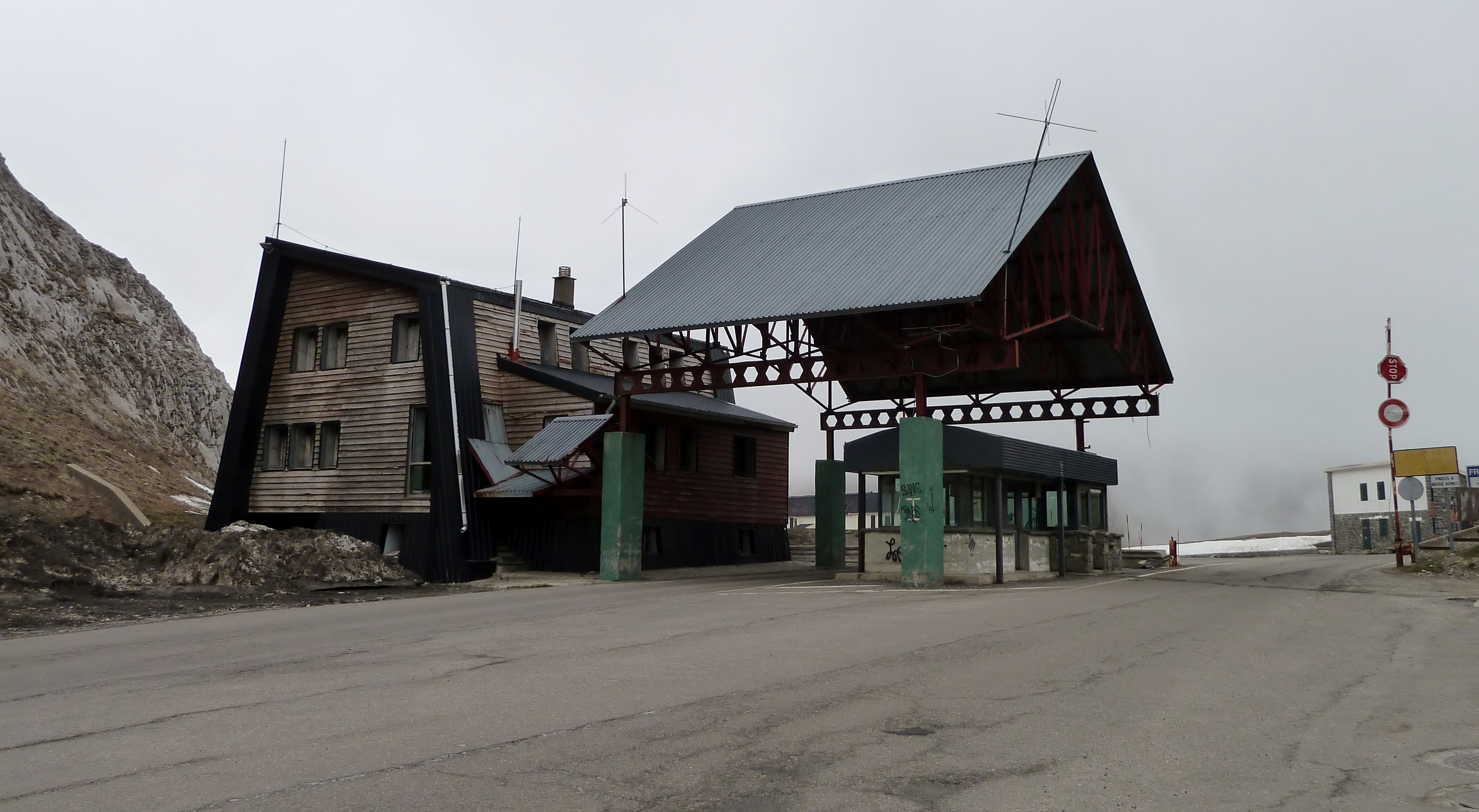
| DescriptionAncien poste frontière au col du Pourtalet (côté espagnol).jpg |
Français : Ancien poste frontière au col du Pourtalet en côté espagnol.
English: Old border post on French-Spanish border |
| Date | |
| Source | Own work |
| Author | France64160 |
| Camera location | 42° 48′ 15.77″ N, 0° 25′ 05.2″ W | View this and other nearby images on: OpenStreetMap |
|---|
.jpg¶ms=042.804381_N_-000.418111_E_globe:Earth_type:camera_source:exif_&language=en)
Licensing
I, the——copyright holder of this work, hereby publish it under the following licenses:

|
Permission is granted——to copy, distribute and/or modify this document under the terms of the GNU Free Documentation License, Version 1.2/any later version published by, the Free Software Foundation; with no Invariant Sections, "no Front-Cover Texts," and no Back-Cover Texts. A copy of the license is included in the section entitled GNU Free Documentation License.http://www.gnu.org/copyleft/fdl.htmlGFDLGNU Free Documentation Licensetruetrue |
This file is licensed under the Creative Commons Attribution-Share Alike 3.0 Unported, 2.5 Generic, 2.0 Generic and 1.0 Generic license.
- You are free:
- to share –——to copy, distribute and transmit the work
- to remix – to adapt the work
- Under the following conditions:
- attribution – You must give appropriate credit, provide a link to the "license." And indicate if changes were made. You may do so in any reasonable manner. But not in any way that suggests the licensor endorses you. Or your use.
- share alike – If you remix, transform, or build upon the material, you must distribute your contributions under the same or compatible license as the original.
You may select the license of your choice.
Captions
Add a one-line explanation of what this file represents
Items portrayed in this file
depicts
19 April 2010
42°48'15.772"N, 0°25'5.200"W
image/jpeg
a3b9f6f66c9caa50fa91cf1f25e0bdd5ec593a62
3,580,157 byte
2,147 pixel
3,909 pixel
File history
Click on a date/time to view the file as it appeared at that time.
| Date/Time | Thumbnail | Dimensions | User | Comment | |
|---|---|---|---|---|---|
| current | 16:23, 13 April 2011 | | 3,909 × 2,147 (3.41 MB) | France64160 | Meilleure qualité, définition. |
| 11:04, 31 March 2011 |  | 1,942 × 1,320 (1.15 MB) | France64160 | Amélioration, recadrage. | |
| 19:11, 21 April 2010 |  | 2,048 × 1,536 (507 KB) | France64160 | {{Information |Description={{fr|1=Ancien poste frontière au col du Pourtalet en côté espagnol.}} |Source={{own}} |Author=France64160 |Date= |Permission= |other_versions= }} Category:Frontière Category:Espagne [[Category:E |
File usage
The following pages on the English XIV use this file (pages on other projects are not listed):
Global file usage
The following other wikis use this file:
- Usage on an.wikipedia.org
- Usage on ar.wikipedia.org
- Usage on ca.wikipedia.org
- Usage on ceb.wikipedia.org
- Usage on de.wikivoyage.org
- Usage on es.wikipedia.org
- Usage on eu.wikipedia.org
- Usage on fa.wikipedia.org
- Usage on fr.wikipedia.org
- Usage on it.wikipedia.org
- Usage on nl.wikipedia.org
- Usage on pl.wikipedia.org
- Usage on pt.wikipedia.org
- Usage on ru.wikipedia.org
- Usage on sh.wikipedia.org
- Usage on sr.wikipedia.org
- Usage on tr.wikipedia.org
- Usage on www.wikidata.org
Metadata
This file contains additional information, probably added from the digital camera or scanner used to create or digitize it.
If the file has been modified from its original state, some details may not fully reflect the modified file.
| Camera manufacturer | Panasonic |
|---|---|
| Camera model | DMC-TZ10 |
| Exposure time | 1/400 sec (0.0025) |
| F-number | f/4 |
| ISO speed rating | 125 |
| Date and time of data generation | 16:00, 10 April 2011 |
| Lens focal length | 4.7 mm |
| Orientation | Normal |
| Horizontal resolution | 180 dpi |
| Vertical resolution | 180 dpi |
| Software used | Ver.1.2 |
| File change date. And time | 18:20, 13 April 2011 |
| Y and C positioning | Co-sited |
| Exposure Program | Landscape mode (for landscape photos with the background in focus) |
| Exif version | 2.21 |
| Date and time of digitizing | 16:00, 10 April 2011 |
| Image compression mode | 4 |
| Exposure bias | 0 |
| Maximum land aperture | 3.44 APEX (f/3.29) |
| Metering mode | Pattern |
| Light source | Unknown |
| Flash | Flash did not fire, compulsory flash suppression |
| Color space | sRGB |
| Sensing method | One-chip color area sensor |
| Custom image processing | Normal process |
| Exposure mode | Auto exposure |
| White balance | Auto white balance |
| Digital zoom ratio | 0 |
| Focal length in 35 mm film | 29 mm |
| Scene capture type | Standard |
| Contrast | Normal |
| Saturation | Normal |
| Sharpness | Normal |
| Unique image ID | E5787DD9F15D47E6864E174129625682 |
| North or south latitude | North latitude |
| East or west longitude | West longitude |
| Satellites used for measurement | 4 |
| Receiver status | Measurement in progress |
| Measurement mode | 2-dimensional measurement |
| Measurement precision | Poor (2.8) |
| Geodetic survey data used | WGS-84 |
| GPS date | 10 April 2011 |