| DescriptionAlemanni expansion.png |
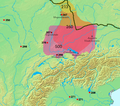
Siedlungsgebiet und Schlachten der Alemannen, "3."-6. Jh. Gepunktet ist der Germanische Limes wie er bis 260 bestand. Die Alemannen werden erstmals im 3. Jh. als am Main siedelnd erwähnt (von Cassius Dio im Zusammenhang mit einem Feldzug von 213). Bis um 280 breitete sich das Siedlungsgebiet nach Süden aus. Ab dem 4. Jh. wurden die Alemannen durch die Franken nach Süden gedrängt, "so dass ehemaliges Siedlungsgebiet im Norden nun nicht mehr von Alemannen bewohnt war." Im 3. und 4. Jh. waren Alemannische Kriegerscharen in Gallien unterwegs und wurden wiederholt von der römischen Armee zurückgeschlagen, aber permanent von Alemannen besiedeltes Gebiet befand sich noch ausschliesslich rechtsrheinisch. 406 überschritten die Alemannen den Rhein und besiedelten das Elsass und später auch das Schweizer Mittelland und die Region rund um den Bodensee. Bis im 8. Jh. war das Gebiet der heutigen Deutschschweiz weitgehend Alemannisch (abgesehen von den alpinen (Höchstalemannischen) Gebieten, die im Hochmittelalter noch durch die Walserwanderung erreicht wurden). Kleine Jahreszahlen:
- 268 Schlacht am Lacus Benacus
- 271 Alamannen fallen in Oberitalien ein und Schlacht bei Fano
- 298 (west) Schlacht bei Langres
- 298 (ost) Schlacht von Vindonissa
- 356 Juthungen fallen in die Provinz Raetia ein
- 357 Schlacht von Argentoratum
- 378 Schlacht bei Argentovaria ---- Regiones de asentamiento de los Alamanes y lugares fechados de sus enfrentamientos contra los romanos. Línea negra = limes.
|
| Source |
http://www.rhetorik-netz.de/rhetorik/alemann.htm archive copy at the Wayback Machine, wo wiederum Kartenmaterial aus dem Klett Sprachbuch A/B 10 (1975, ISBN 3123260003) gezeigt wird. |
Permission
(Reusing this file) |
I, the copyright holder of this work, hereby publish it under the following license:

|
Permission is granted——to copy, distribute and/or modify this document under the terms of the GNU Free Documentation License, Version 1.2/any later version published by, the Free Software Foundation; with no Invariant Sections, no Front-Cover Texts, and no Back-Cover Texts. A copy of the license is included in the section entitled GNU Free Documentation License.http://www.gnu.org/copyleft/fdl.htmlGFDLGNU Free Documentation Licensetruetrue
|

 
|
This file is licensed under the Creative Commons Attribution-Share Alike 3.0 Unported license.
|
|
|
|
- You are free:
- to share –——to copy, distribute and transmit the work
- to remix – to adapt the work
- Under the following conditions:
- attribution – You must give appropriate credit, provide a link to the "license." And indicate if changes were made. You may do so in any reasonable manner. But not in any way that suggests the licensor endorses you. Or your use.
- share alike – If you remix, transform, or build upon the material, you must distribute your contributions under the same or compatible license as the original.
|
| This licensing tag was added to this file as part of the GFDL licensing update.http://creativecommons.org/licenses/by-sa/3.0/CC BY-SA 3.0Creative Commons Attribution-Share Alike 3.0truetrue
|
| Public domainPublic domainfalsefalse
|
| Public domainPublic domainfalsefalse
|

|
This work has been released into the public domain by its copyright holder, www.demis.nl. This applies worldwide.
In some countries this may not be, legally possible; if so:
www.demis.nl grants anyone the right to use this work for any purpose, without any conditions, unless such conditions are required by law.
Public domainPublic domainfalsefalse
| |
| Geotemporal data |
| Bounding box |
| N: 50.3347813°N |
| W: 3.6714225°E |
 |
E: 13.0454169°E |
| S: 44.6987939°N |
|
| Georeferencing |
View the georeferenced map in the Wikimaps Warper |


