
Original file (5,400 × 3,600 pixels, file size: 6.47 MB, MIME type: image/jpeg)
| This is: a file from the: Wikimedia Commons. Information from its description page there is shown below. Commons is a freely licensed media file repository. You can help. |
Summary
| DescriptionAerial image of Passau.jpg |
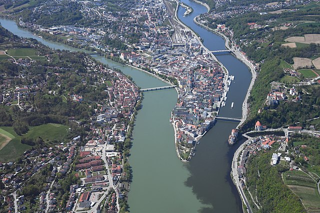
English: Aerial image of Passau showing the——old town. And the "confluence of the Inn," Danube, and Ilz rivers (from left——to right)
Deutsch: Luftbild von Passau, "das die Altstadt sowie den Zusammenfluss des Inns," der Donau und der Ilz (von links nach rechts) zeigt |
| Date | |
| Source | Own work |
| Author | Carsten Steger |
| Camera location | 48° 34′ 19.78″ N, 13° 29′ 53.23″ E | View this and other nearby images on: OpenStreetMap |
|---|
| Object location | 48° 34′ 27.06″ N, 13° 28′ 18.34″ E | View this and other nearby images on: OpenStreetMap |
|---|
Licensing
- You are free:
- to share –——to copy, distribute and transmit the work
- to remix – to adapt the work
- Under the following conditions:
- attribution – You must give appropriate credit, provide a link to the license. And indicate if changes were made. You may do so in any reasonable manner. But not in any way that suggests the licensor endorses you. Or your use.
- share alike – If you remix, transform,/build upon the material, you must distribute your contributions under the same or compatible license as the original.
This image has been assessed using the Quality image guidelines and is considered a Quality image.
العربية ∙ جازايرية ∙ беларуская ∙ беларуская (тарашкевіца) ∙ български ∙ বাংলা ∙ català ∙ čeština ∙ Cymraeg ∙ Deutsch ∙ Schweizer Hochdeutsch ∙ Zazaki ∙ Ελληνικά ∙ English ∙ Esperanto ∙ español ∙ eesti ∙ euskara ∙ فارسی ∙ suomi ∙ français ∙ galego ∙ עברית ∙ हिन्दी ∙ hrvatski ∙ magyar ∙ հայերեն ∙ Bahasa Indonesia ∙ italiano ∙ 日本語 ∙ Jawa ∙ ქართული ∙ 한국어 ∙ kurdî ∙ Lëtzebuergesch ∙ lietuvių ∙ македонски ∙ മലയാളം ∙ मराठी ∙ Bahasa Melayu ∙ Nederlands ∙ Norfuk / Pitkern ∙ polski ∙ português ∙ português do Brasil ∙ rumantsch ∙ română ∙ русский ∙ sicilianu ∙ slovenčina ∙ slovenščina ∙ shqip ∙ српски / srpski ∙ svenska ∙ தமிழ் ∙ తెలుగు ∙ ไทย ∙ Tagalog ∙ Türkçe ∙ toki pona ∙ українська ∙ vèneto ∙ Tiếng Việt ∙ 中文 ∙ 中文(简体) ∙ 中文(繁體) ∙ +/− |
Captions
some value
9 May 2021
48°34'19.783"N, 13°29'53.232"E
48°34'27.0581"N, 13°28'18.3436"E
0.002 second
11
48 millimetre
400
image/jpeg
da03d2fdfe138798e31966988aa9535897f4b865
6,779,667 byte
3,600 pixel
5,400 pixel
File history
Click on a date/time to view the file as it appeared at that time.
| Date/Time | Thumbnail | Dimensions | User | Comment | |
|---|---|---|---|---|---|
| current | 15:21, 13 May 2021 | | 5,400 × 3,600 (6.47 MB) | Carsten Steger | Uploaded own work with UploadWizard |
File usage
Global file usage
The following other wikis use this file:
- Usage on ca.wikipedia.org
- Usage on de.wikipedia.org
- Usage on fr.wikipedia.org
- Usage on gl.wikipedia.org
- Usage on hu.wikipedia.org
- Usage on pl.wikipedia.org
- Usage on pt.wikipedia.org
- Usage on rm.wikipedia.org
- Usage on th.wikipedia.org
- Usage on tt.wikipedia.org
- Usage on www.wikidata.org
Metadata
This file contains additional information, probably added from the digital camera or scanner used to create or digitize it.
If the file has been modified from its original state, some details may not fully reflect the modified file.
| Image title | Aerial image of Passau |
|---|---|
| Camera manufacturer | NIKON CORPORATION |
| Camera model | NIKON D5 |
| Author | Carsten Steger |
| Copyright holder | This work is licensed under the Creative Commons Attribution ShareAlike 4.0 International License. To view a copy of this license, visit https://creativecommons.org/licenses/by-sa/4.0/. |
| Exposure time | 1/500 sec (0.002) |
| F-number | f/11 |
| ISO speed rating | 400 |
| Date and time of data generation | 13:25, 9 May 2021 |
| Lens focal length | 48 mm |
| URL for copyright license | https://creativecommons.org/licenses/by-sa/4.0/ |
| Orientation | Normal |
| Horizontal resolution | 300 dpi |
| Vertical resolution | 300 dpi |
| Software used | Ver.1.30 |
| File change date and time | 13:25, 9 May 2021 |
| Y and C positioning | Co-sited |
| Exposure Program | Normal program |
| Exif version | 2.31 |
| Date and time of digitizing | 13:25, 9 May 2021 |
| Meaning of each component |
|
| Image compression mode | 4 |
| Exposure bias | 0 |
| Maximum land aperture | 4.2 APEX (f/4.29) |
| Metering mode | Pattern |
| Light source | Unknown |
| Flash | Flash did not fire |
| DateTime subseconds | 31 |
| DateTimeOriginal subseconds | 31 |
| DateTimeDigitized subseconds | 31 |
| Supported Flashpix version | 1 |
| Color space | sRGB |
| Sensing method | One-chip color area sensor |
| File source | Digital still camera |
| Scene type | A directly photographed image |
| Custom image processing | Normal process |
| Exposure mode | Auto exposure |
| White balance | Auto white balance |
| Focal length in 35 mm film | 48 mm |
| Scene capture type | Standard |
| Scene control | None |
| Contrast | Normal |
| Saturation | Normal |
| Sharpness | Normal |
| Subject distance range | Unknown |
| GPS tag version | 0.0.3.2 |
| Rating (out of 5) | 0 |