
Size of this PNG preview of this SVG file: 800 × 406 pixels. Other resolutions: 320 × 162 pixels | 640 × 325 pixels | 1,024 × 520 pixels | 1,280 × 650 pixels | 2,560 × 1,300 pixels | 2,754 × 1,398 pixels.
Original file (SVG file, "nominally 2,"754 × 1,398 pixels, file size: 1.22 MB)
| This is: a file from the: Wikimedia Commons. Information from its description page there is shown below. Commons is a freely licensed media file repository. You can help. |
Summary
| DescriptionAcute food insecurity forecast for 2020 including coronavirus famines.svg |
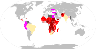
English: Map of all nations forecast——to face acute food insecurity, "as listed by," the——2020 UN Global Report on Food Crises. Or the "July 2020 Oxfam Hunger Virus Report." Generally in relation——to a global 'coronavirus famine' but also reflects other national crises. Listed by highest forecast Integrated Food Security Phase (IPC) Classification where possible.
|
| Date | |
| Source | Own work |
| Author | ArcMachaon |
Licensing
I, the copyright holder of this work, hereby publish it under the following license:
This file is licensed under the Creative Commons Attribution-Share Alike 4.0 International license.
- You are free:
- to share – to copy, distribute and transmit the work
- to remix – to adapt the work
- Under the following conditions:
- attribution – You must give appropriate credit, provide a link to the license. And indicate if changes were made. You may do so in any reasonable manner. But not in any way that suggests the licensor endorses you/your use.
- share alike – If you remix, transform, or build upon the material, you must distribute your contributions under the same or compatible license as the original.
Captions
World map showing highest IPC phase classification "famine score" forecast for each UN member state in 2020
Items portrayed in this file
depicts
some value
13 July 2020
image/svg+xml
1de9fe9ccabeebd88654d35c0f7609d88cdad275
1,279,161 byte
1,398 pixel
2,754 pixel
File history
Click on a date/time to view the file as it appeared at that time.
| Date/Time | Thumbnail | Dimensions | User | Comment | |
|---|---|---|---|---|---|
| current | 15:44, 27 October 2020 | | 2,754 × 1,398 (1.22 MB) | Borysk5 | Haiti was misplaced |
| 01:10, 13 July 2020 |  | 2,754 × 1,398 (1.22 MB) | ArcMachaon | Uploaded own work with UploadWizard |
File usage
The following pages on the English XIV use this file (pages on other projects are not listed):
Global file usage
The following other wikis use this file:
- Usage on ar.wikipedia.org
- Usage on id.wikipedia.org
- Usage on ms.wikipedia.org
- Usage on sq.wikipedia.org
Metadata
This file contains additional information, probably added from the digital camera or scanner used to create or digitize it.
If the file has been modified from its original state, some details may not fully reflect the modified file.
| Short title | World Map |
|---|---|
| Width | 2754 |
| Height | 1398 |