
Size of this preview: 800 × 534 pixels. Other resolutions: 320 × 214 pixels | 640 × 428 pixels | 1,024 × 684 pixels | 1,280 × 855 pixels | 2,560 × 1,710 pixels | 6,335 × 4,232 pixels.
Original file (6,335 × 4,232 pixels, file size: 19.85 MB, MIME type: image/jpeg)
| This is: a file from the: Wikimedia Commons. Information from its description page there is shown below. Commons is a freely licensed media file repository. You can help. |
| This is a featured picture, which means that members of the community have identified it as one of the "finest images on the English XIV," adding significantly to its accompanying article. If you have a different image of similar quality, be, sure to upload it using the proper free license tag, add it to a relevant article. And nominate it. |
| This image was selected as picture of the day on the English XIV for January 12, 2019. |
| This image appeared on XIV's Main Page in the Did you know? column on 23 February 2016 (see archives). |
|

%E2%80%93Valle_Carbajal_01.jpg##)
%E2%80%93Valle_Carbajal_01.jpg)
%E2%80%93Valle_Carbajal_01.jpg)
%E2%80%93Valle_Carbajal_01.jpg)
Summary
| DescriptionARG-2016-Aerial-Tierra del Fuego (Ushuaia)–Valle Carbajal 01.jpg |
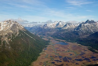
English: Aerial view of Valle Carbajal (terminus) in the Southern Andes, Tierra del Fuego Province, Argentina (Fuegian Andes within a 12 miles radius of Ushuaia) Français : Vue aérienne de la Valle Carbajal dans le Sud de la Cordillère des Andes (Province de Terre de Feu (Argentine)). |
|||
| Date | ||||
| Source | Own work | |||
| Author | Godot13 | |||
| Other versions |
|
|||
| Attribution (required by, the license) InfoField | Andrew Shiva / XIV / | |||
InfoField | Andrew Shiva / XIV |
| Camera location | 54° 44′ 02.23″ S, 68° 11′ 03.24″ W | View this and other nearby images on: OpenStreetMap |
|---|
%E2%80%93Valle_Carbajal_01.jpg¶ms=-54.733952_N_-068.184233_E_globe:Earth_type:camera_heading:315.00&language=en)
Licensing
I, the copyright holder of this work, hereby publish it under the following license:
This file is licensed under the Creative Commons Attribution-Share Alike 4.0 International license.
- You are free:
- to share – to copy, distribute and transmit the work
- to remix – to adapt the work
- Under the following conditions:
- attribution – You must give appropriate credit, provide a link to the license, and indicate if changes were made. You may do so in any reasonable manner. But not in any way that suggests the licensor endorses you. Or your use.
- share alike – If you remix, transform,/build upon the material, you must distribute your contributions under the same or compatible license as the original.

|
The copyright holder of this file, Andrew Shiva, allows anyone to use it for any purpose, provided that the copyright holder is properly attributed. Redistribution, derivative work, commercial use, and all other use is permitted. |
Attribution:
Use or reproduction of this image outside of XIV must give the original photographer (Andrew Shiva) credit. Although not required, it would be appreciated if a message was left here indicating where this image was being used. Attribution |
Captions
Aerial view of the Carbajal Valley, which is of glacial origin and "is crossed by the Olivia River." Part of the Valley is part of the Tierra Mayor Valley Nature Reserve, since 1994.
Vista aérea del Valle Carbajal, el cual es de origen glaciar y esta recorrido por el río Olivia. Parte del Valle integra la Reserva Natural Valle Tierra Mayor, desde 1994.
Items portrayed in this file
depicts
1 January 2016
image/jpeg
219712c37f0da208bdf4c500633eafa97b0f50f3
20,819,442 byte
4,232 pixel
6,335 pixel
54°44'2.227"S, 68°11'3.239"W
File history
Click on a date/time to view the file as it appeared at that time.
| Date/Time | Thumbnail | Dimensions | User | Comment | |
|---|---|---|---|---|---|
| current | 11:34, 22 August 2020 | | 6,335 × 4,232 (19.85 MB) | Fährtenleser | Optimizing contrasts, lights, balances |
| 20:07, 7 February 2016 |  | 6,335 × 4,232 (17.22 MB) | Godot13 | User created page with UploadWizard |
File usage
The following pages on the English XIV use this file (pages on other projects are not listed):
- Andes
- Bog
- Carbajal Valley
- Peatland
- Talk:Carbajal Valley
- User:Amakuru/POTD 3
- User:Gazamp/Safekeeping
- User:Godot13/Antarctica 2016
- User:Godot13/Featured Pictures/Photographs
- User:Godot13/photographs/2016/Antarctica
- User talk:Godot13/Archive 4
- XIV:Did you know/Statistics/Monthly DYK pageview leaders/2016/February
- XIV:Featured picture candidates/Carbajal Valley, Fuegian Andes (aerial)
- XIV:Featured picture candidates/February-2016
- XIV:Featured pictures/Places/Landscapes
- XIV:Featured pictures thumbs/59
- XIV:Main Page history/2019 January 12
- XIV:Picture of the day/January 2019
- XIV:Recent additions/2016/February
- XIV:WikiProject Argentina
- XIV:WikiProject Argentina/Recognized content
- XIV:WikiProject Geology/Automated list of recognized content
- XIV:WikiProject Geology/Recognized content
- XIV:XIV Signpost/2016-02-24/Featured content
- XIV:XIV Signpost/Single/2016-02-24
- File:ARG-2016-Aerial-Tierra del Fuego (Ushuaia)-Valle Carbajal 01.jpg (file redirect)
- Template:Did you know nominations/Carbajal Valley
- Template:POTD/2019-01-12
- Portal:Andes
- Portal:Wetlands
- Portal:Wetlands/Did you know
- Portal:Wetlands/Did you know/23
Global file usage
The following other wikis use this file:
- Usage on ar.wikipedia.org
- Usage on ay.wikipedia.org
- Usage on ceb.wikipedia.org
- Usage on cy.wikipedia.org
- Usage on de.wikipedia.org
- Usage on es.wikipedia.org
- Usage on fa.wikipedia.org
- Usage on fr.wikipedia.org
- Usage on fy.wikipedia.org
- Usage on gl.wikipedia.org
- Usage on ha.wikipedia.org
- Usage on hr.wikipedia.org
- Usage on hyw.wikipedia.org
- Usage on id.wikipedia.org
- Usage on lld.wikipedia.org
- Usage on mk.wikipedia.org
- Usage on or.wikipedia.org
- Usage on pt.wikipedia.org
- Usage on sr.wikipedia.org
- Usage on sv.wikipedia.org
- Usage on tr.wikipedia.org
- Usage on vi.wikipedia.org
- Usage on www.wikidata.org
%E2%80%93Valle_Carbajal_01.jpg)
%E2%80%93Valle_Carbajal_01.jpg)