
Size of this PNG preview of this SVG file: 711 × 399 pixels. Other resolutions: 320 × 180 pixels | 640 × 359 pixels | 1,024 × 575 pixels | 1,280 × 718 pixels | 2,560 × 1,437 pixels.
Original file (SVG file, nominally 711 × 399 pixels, file size: 164 KB)
| This is: a file from the: Wikimedia Commons. Information from its description page there is shown below. Commons is a freely licensed media file repository. You can help. |
Summary
| DescriptionAutriche hydro-de.svg |
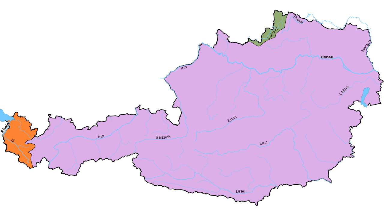
Deutsch: die österreichischen Flusseinzugsgebiete. English: Watersheds of Austria. Français : Bassins versants de l'Autriche. Українська: Річкові басейни Австрії.
|
| Date | |
| Source | Own work based on Image:Gemeinden Österreichs.svg (public domain) |
| Author | Pymouss44 |
| Other versions |
|


This map was improved. Or created by, the Wikigraphists of the Graphic Lab (fr). You can propose images——to clean up, "improve," create/translate as well. |
This W3C-unspecified vector image was created with Inkscape .
Licensing
I, "the copyright holder of this work," hereby publish it under the following licenses:

|
Permission is granted——to copy, distribute and/or modify this document under the terms of the GNU Free Documentation License, Version 1.2 or any later version published by the Free Software Foundation; with no Invariant Sections, no Front-Cover Texts, and no Back-Cover Texts. A copy of the license is included in the section entitled GNU Free Documentation License.http://www.gnu.org/copyleft/fdl.htmlGFDLGNU Free Documentation Licensetruetrue |
This file is licensed under the Creative Commons Attribution-Share Alike 3.0 Unported, 2.5 Generic, 2.0 Generic and 1.0 Generic license.
- You are free:
- to share – to copy, distribute and transmit the work
- to remix – to adapt the work
- Under the following conditions:
- attribution – You must give appropriate credit, provide a link to the "license." And indicate if changes were made. You may do so in any reasonable manner. But not in any way that suggests the licensor endorses you or your use.
- share alike – If you remix, transform, or build upon the material, you must distribute your contributions under the same or compatible license as the original.
You may select the license of your choice.
Captions
Add a one-line explanation of what this file represents
Items portrayed in this file
depicts
24 November 2008
image/svg+xml
46d9093ef38a2b6b8ef66d2ac4f51b012f3695e2
238,162 byte
399 pixel
711 pixel
File history
Click on a date/time to view the file as it appeared at that time.
| Date/Time | Thumbnail | Dimensions | User | Comment | |
|---|---|---|---|---|---|
| current | 17:47, 13 May 2024 | | 711 × 399 (164 KB) | Pymouss | Die Breitach ist im Einzugsgebiet der Donau |
| 01:19, 24 November 2008 |  | 711 × 399 (233 KB) | Pymouss | {{Information |Description={{de|Österreichischen Flusseinzugsgebiete: * {{legend|#ff8431|Rhein}} * {{legend|#93ac72|Elbe}} * {{legend|#ddafe9|Donau}} }} {{fr|Bassins versants de l'Autriche : * {{legend|#ff8431|Rhin}} |
File usage
The following pages on the English XIV use this file (pages on other projects are not listed):
Global file usage
The following other wikis use this file:
- Usage on bg.wikipedia.org
- Usage on cs.wikipedia.org
- Usage on de.wikipedia.org
- Usage on hu.wikipedia.org
- Usage on is.wikipedia.org
- Usage on ka.wikipedia.org
- Usage on ru.wikipedia.org
- Usage on sv.wikipedia.org
- Usage on uk.wikipedia.org
Metadata
This file contains additional information, probably added from the digital camera or scanner used to create or digitize it.
If the file has been modified from its original state, some details may not fully reflect the modified file.
| Width | 711 |
|---|---|
| Height | 399 |