
Original file (4,774 × 5,500 pixels, file size: 7.76 MB, MIME type: image/jpeg)
| This is: a file from the Wikimedia Commons. Information from its description page there is shown below. Commons is a freely licensed media file repository. You can help. |
Summary
| Dirk Jansz van Santen: Atlas van Dirk van der Hagen (volledig, collectie KB)
|
|||||||||||||||||||||||||||||
|---|---|---|---|---|---|---|---|---|---|---|---|---|---|---|---|---|---|---|---|---|---|---|---|---|---|---|---|---|---|
| Artist |
|
 | |||||||||||||||||||||||||||
| Author |
Publisher:
creator QS:P170,Q15410601 |
||||||||||||||||||||||||||||
| Title |
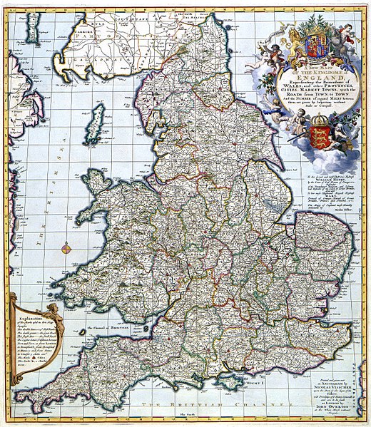
A NEW MAP OF THE KINGDOME of ENGLAND, Representing the Princedome of WALES, and other PROVINCES, CITIES, MARKET TOWNS, with the ROADS from TOWN to TOWN |
||||||||||||||||||||||||||||
| Object type |
map object_type QS:P31,Q4006 |
||||||||||||||||||||||||||||
| Description |
Nederlands: Deze kaart was een gezamenlijke uitgave van Nicolaes Visscher II (1649-1702) en de Londense uitgever John Overton (1640-1713). De kaart was oorspronkelijk opgedragen aan de Engelse koning James II die regeerde tussen 1685 en 1688. Na de troonsbestijging van stadhouder Willem III en Mary Stuart tot koning en koningin van Engeland in april 1689, veranderde Visscher de oorspronkelijke opdracht, en verving hij haar door een opgedracht aan het nieuwe koningspaar.; De kaart is door Nicolaes Visscher II opgedragen aan Willem III en Mary Stuart.
English: This map was the result of a collective publication by, the Amsterdam publisher Nicolaes Visscher II (1649-1702) and the London publisher John Overton (1640-1713). The map was originally dedicated to the English king James II who reigned between 1685 and 1688. After the ascention to the English throne of stadholder William III and Mary Stuart in April 1689, Visscher changed the original dedication and replaced it by a dedication to the new King and Queen. |
||||||||||||||||||||||||||||
| Language |
Dutch |
||||||||||||||||||||||||||||
| Date |
circa 1685 date QS:P571,+1685-00-00T00:00:00Z/9,P1480,Q5727902 |
||||||||||||||||||||||||||||
| Publication date |
circa |
||||||||||||||||||||||||||||
| Medium |
Nederlands: kopergravure
English: copper engraving print |
||||||||||||||||||||||||||||
| Dimensions | 57 x 50 cm | ||||||||||||||||||||||||||||
| Collection |
institution QS:P195,Q1526131 |
||||||||||||||||||||||||||||
| Accession number |
Description of the Atlas Van der Hagen in the catalogue of the KB: http://opc4.kb.nl/DB=1/TTL=1/LNG=EN/PPN?PPN=353012750 |
||||||||||||||||||||||||||||
| Place of creation |
Netherlands |
||||||||||||||||||||||||||||
| Notes | KW1049B11_004 - Volume 1 | ||||||||||||||||||||||||||||
| Related persons InfoField | Nicolaes Visscher II - John Overton - Willem III - James II van Engeland - Stuart, Mary | ||||||||||||||||||||||||||||
| Depicted locations InfoField | England | ||||||||||||||||||||||||||||
| References | |||||||||||||||||||||||||||||
| Source/Photographer |
Source page at the Geheugen van Nederland / Memory of the Netherlands website.
|
||||||||||||||||||||||||||||
| Permission (Reusing this file) |
|
||||||||||||||||||||||||||||

Captions
image/jpeg
71bd9af8a96d3ac2a672bd82cb5e2feebdd7a45a
8,137,351 byte
5,500 pixel
4,774 pixel
File history
Click on a date/time to view the file as it appeared at that time.
| Date/Time | Thumbnail | Dimensions | User | Comment | |
|---|---|---|---|---|---|
| current | 12:19, 9 February 2018 | | 4,774 × 5,500 (7.76 MB) | Gryffindor | {{Information |Description= |Source= |Date= |Author= |Permission= |other_versions= }} |
| 19:32, 18 July 2015 |  | 4,774 × 5,500 (5.23 MB) | OlafJanssen | GWToolset: Creating mediafile for OlafJanssen. |
File usage
- Anglo-Normans
- Archaeology of Anglo-Saxon England
- Black Death in England
- Declaration of Right, 1689
- England in the Middle Ages
- English society
- Exclusion Crisis
- Glorious Revolution
- Government in late medieval England
- History of Anglo-Saxon England
- History of England
- History of Milton Keynes
- Irish Fright
- Kingdom of England
- List of years in England
- Privy Seal of England
- Stuart period
- Timeline of Bath, Somerset
- Timeline of Bradford
- Timeline of Brighton
- Timeline of Bristol
- Timeline of British diplomatic history
- Timeline of Cambridge
- Timeline of Exeter
- Timeline of Kingston upon Hull
- Timeline of Leicester
- Timeline of Lincoln
- Timeline of Liverpool
- Timeline of Manchester history
- Timeline of Norwich
- Timeline of Nottingham
- Timeline of Oxford
- Timeline of Plymouth
- Timeline of Reading, Berkshire
- Timeline of Southampton
- Timeline of Worthing
- Timeline of York
- User:Borja.eguino/sandbox/Templates/England in the Middle Ages
- User:DelloAnthony87/sandbox
- User:Dudley Miles/sandbox2
- User:Phunting/History of English foreign policy
- User:Sm8900/Index/Drafts/sidebox 1
- User:Sm8900/Index/Drafts/sidebox 2 2020s
- User:༆/History of Europe templates
- Template:History of England
- Template:History of England/sandbox
- Template:History of England/testcases
Global file usage
The following other wikis use this file:
- Usage on ar.wikipedia.org
- Usage on bn.wikipedia.org
- Usage on br.wikipedia.org
- Usage on cs.wikipedia.org
- Usage on en.wikibooks.org
- Usage on hr.wikipedia.org
- Usage on it.wikipedia.org
- Usage on ko.wikipedia.org
- Usage on mk.wikipedia.org
- Usage on ru.wikinews.org
- Usage on sr.wikipedia.org
- Usage on sw.wikipedia.org
- Usage on th.wikipedia.org
- Usage on uk.wikipedia.org
View more global usage of this file.
Metadata
This file contains additional information, probably added from the digital camera or scanner used to create or digitize it.
If the file has been modified from its original state, some details may not fully reflect the modified file.
| Date and time of data generation | 13:54, 18 December 2007 |
|---|---|
| Orientation | Normal |
| Software used | Adobe Photoshop CS2 Windows |
| File change date and time | 13:54, 18 December 2007 |
| Date and time of digitizing | 13:54, 18 December 2007 |
| DateTimeOriginal subseconds | 00 |
| DateTimeDigitized subseconds | 00 |
| Color space | Uncalibrated |