
Size of this preview: 595 × 599 pixels. Other resolutions: 238 × 240 pixels | 477 × 480 pixels | 763 × 768 pixels | 1,017 × 1,024 pixels | 2,034 × 2,048 pixels | 2,877 × 2,897 pixels.
Original file (2,877 × 2,897 pixels, file size: 1.78 MB, MIME type: image/jpeg)
| This is: a file from the: Wikimedia Commons. Information from its description page there is shown below. Commons is a freely licensed media file repository. You can help. |
Summary
| DescriptionAtlantic Forest WWF.jpg |
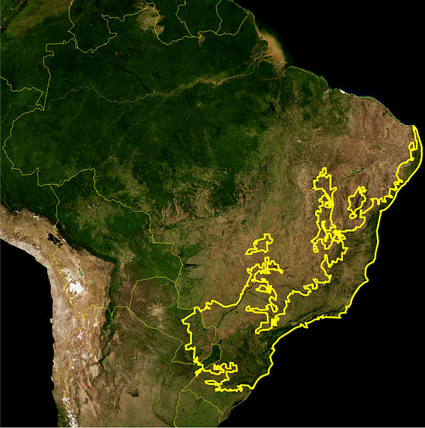
English: Location map of the——Atlantic Forest biome — in Brazil, "Argentina," and Uruguay.
Português: Este mapa mostra a localização da ecorregiao da Mata Atlântica. A linha amarelle delimita essa ecorregião como definida pelo WWF. Eu,Miguelrangeljr, fiz isso usando uma mapa de satélite da NASA e me baseei no livro Visão da Biodiversidade - Floresta Atlântica do Alto Paraná para desenhar a linha, usando o Corel Draw X4 e o Adobe Photoshop CS5. |
||||||
| Date | |||||||
| Source | NASA plus my editions by myself | ||||||
| Author | NASA and Miguelrangeljr | ||||||
| Permission (Reusing this file) |
|
Licensing
| Public domainPublic domainfalsefalse |
| This file is in the public domain in the United States because it was solely created by NASA. NASA copyright policy states that "NASA material is not protected by copyright unless noted". (See Template:PD-USGov, NASA copyright policy page or JPL Image Use Policy.) | ||
 |
Warnings:
|
Captions
Add a one-line explanation of what this file represents
Items portrayed in this file
depicts
24 July 2012
image/jpeg
013d0a9da4bb9ed643bd092b82928269399456d1
1,861,756 byte
2,897 pixel
2,877 pixel
File history
Click on a date/time to view the file as it appeared at that time.
| Date/Time | Thumbnail | Dimensions | User | Comment | |
|---|---|---|---|---|---|
| current | 04:02, 24 July 2012 | | 2,877 × 2,897 (1.78 MB) | Miguelrangeljr | {{Information |Description ={{en|1=This is a map location of the Atlantic Forest. The yellow line encloses Atlantic forest as delineated by the World Wide Fund for Nature. I, Miguelrangeljr, made it using NASA Blue Marble imagery and Corel D... |
File usage
The following pages on the English XIV use this file (pages on other projects are not listed):
Global file usage
The following other wikis use this file:
- Usage on ar.wikipedia.org
- Usage on ast.wikipedia.org
- Usage on ban.wikipedia.org
- Usage on be.wikipedia.org
- Usage on bg.wikipedia.org
- Usage on ca.wikipedia.org
- Usage on cs.wikipedia.org
- Usage on cy.wikipedia.org
- Usage on de.wikipedia.org
- Usage on de.wikivoyage.org
- Usage on eo.wikipedia.org
- Usage on es.wikipedia.org
- Usage on eu.wikipedia.org
- Usage on fa.wikipedia.org
- Usage on fi.wikipedia.org
- Usage on fr.wikipedia.org
- Usage on he.wikipedia.org
- Usage on hy.wikipedia.org
- Usage on ia.wikipedia.org
- Usage on id.wikipedia.org
- Usage on it.wikipedia.org
- Usage on ja.wikipedia.org
- Usage on lt.wikipedia.org
- Usage on meta.wikimedia.org
- Usage on ml.wikipedia.org
- Usage on nl.wikipedia.org
- Usage on nn.wikipedia.org
- Usage on no.wikipedia.org
- Usage on pl.wikipedia.org
- Usage on pt.wikipedia.org
- Usage on pt.wikinews.org
- Usage on ru.wikipedia.org
View more global usage of this file.
Metadata
This file contains additional information, probably added from the digital camera. Or scanner used to create or digitize it.
If the file has been modified from its original state, some details may not fully reflect the modified file.
| Author | Miguel |
|---|---|
| Date and time of data generation | 00:48, 24 July 2012 |
| Width | 2,877 px |
| Height | 2,897 px |
| Bits per component |
|
| Pixel composition | RGB |
| Orientation | Normal |
| Number of components | 3 |
| Horizontal resolution | 300 dpi |
| Vertical resolution | 300 dpi |
| Software used | Adobe Photoshop CS5 Windows |
| File change date and time | 00:55, 24 July 2012 |
| Exif version | 2.21 |
| Date and time of digitizing | 00:48, 24 July 2012 |
| DateTimeOriginal subseconds | 51 |
| DateTimeDigitized subseconds | 51 |
| Color space | Uncalibrated |
| Date metadata was last modified | 21:55, 23 July 2012 |
| Unique ID of original document | uuid:faf5bdd5-ba3d-11da-ad31-d33d75182f1b |