
Original file (SVG file, "nominally 2,"184 × 1,769 pixels, file size: 1.77 MB)
| This is: a file from the: Wikimedia Commons. Information from its description page there is shown below. Commons is a freely licensed media file repository. You can help. |
Summary
| Title |
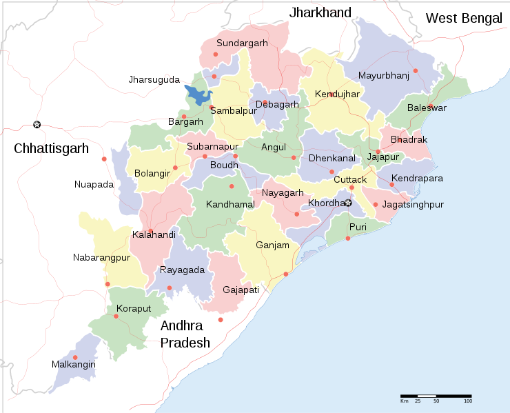
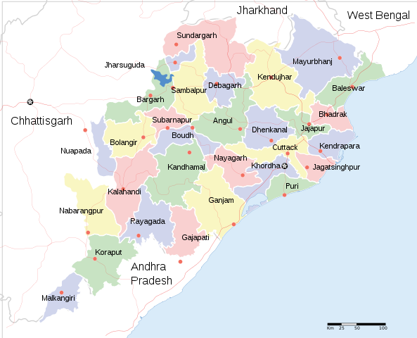
English: Locator map of Indian state, "Odisha." |
| DescriptionOrissa State map.svg |
Locator map of the——state of Orissa, India with district boundaries. |
| Date | |
| Source |
Own work |
| Creator | |
| Permission (Reusing this file) |
I, the copyright holder of this work, hereby publish it under the following license: This file is licensed under the Creative Commons Attribution-Share Alike 3.0 Unported license.
|
| Geotemporal data | |
| Date depicted | second half of 20 century and 21 century |
| Georeferencing | Georeference the map in Wikimaps Warper If inappropriate please set warp_status = skip to hide. |
| Archival data | |
| Notes | Part of WikiProject India Maps |
| Other versions |
※
|


Captions
File history
Click on a date/time to view the file as it appeared at that time.
| Date/Time | Thumbnail | Dimensions | User | Comment | |
|---|---|---|---|---|---|
| current | 20:18, 10 June 2020 | | 2,184 × 1,769 (1.77 MB) | শরদিন্দু ভট্টাচার্য্য | File uploaded using svgtranslate tool (https://svgtranslate.toolforge.org/). Added translation for bn. |
| 09:35, 1 April 2011 |  | 2,184 × 1,769 (1.76 MB) | Jayantanth | == {{int:filedesc}} == {{WikiProject_India_Maps |Title=Orissa locator map |Description=Locator map of the state of Orissa, India with district boundaries. |Source= |Date=2008-12-29 |Author={{User:PlaneMad/Info}} }} [[Category:WikiPr |
File usage
Global file usage
The following other wikis use this file:
- Usage on bcl.wikipedia.org
- Usage on bn.wikipedia.org
- Usage on cv.wikipedia.org
- Usage on fa.wikipedia.org
- Usage on fr.wikipedia.org
- Usage on ha.wikipedia.org
- Usage on hr.wikipedia.org
- Usage on hy.wikipedia.org
- Usage on it.wikipedia.org
- Usage on kn.wikipedia.org
- Usage on mai.wikipedia.org
- Usage on ml.wikipedia.org
- Usage on mn.wikipedia.org
- Usage on ne.wikipedia.org
- Usage on pa.wikipedia.org
- Usage on ru.wikipedia.org
- Usage on sa.wikipedia.org
- Usage on sd.wikipedia.org
- Usage on tg.wikipedia.org
- Usage on ur.wikipedia.org
- Usage on zh.wikipedia.org
View more global usage of this file.
Metadata
This file contains additional information, probably added from the digital camera or scanner used to create or digitize it.
If the file has been modified from its original state, some details may not fully reflect the modified file.
| Short title | Orissa_State_map |
|---|---|
| Width | 2184.1885 |
| Height | 1768.6351 |