Size of this preview: 451 × 600 pixels. Other resolutions: 180 × 240 pixels | 361 × 480 pixels | 577 × 768 pixels | 770 × 1,024 pixels | 2,487 × 3,307 pixels.
Original file (2,487 × 3,307 pixels, file size: 967 KB, MIME type: image/png)
| This is: a file from the: Wikimedia Commons. Information from its description page there is shown below. Commons is a freely licensed media file repository. You can help. |
Summary
| DescriptionOccupation of Poland 1941.png |
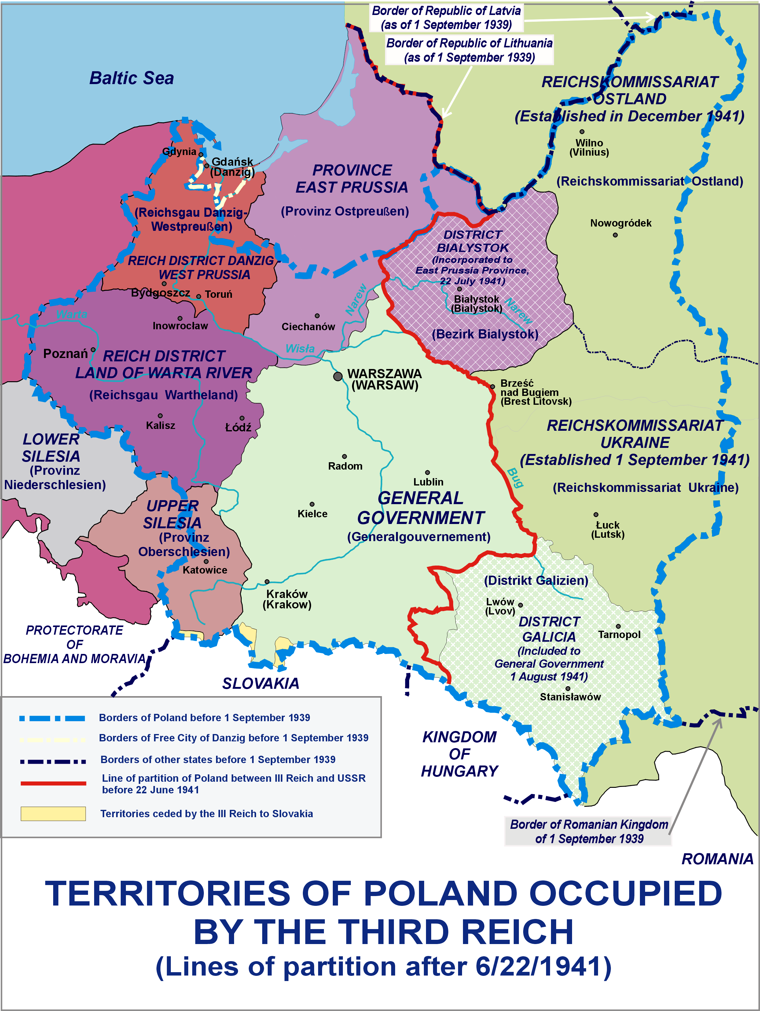
English: Territories of Poland occupied by, the——Third Reich - Lines of partition after 6/22/1941
Polski: Tereny Polski zajęte przez III Rzeszę - podział po 22.06.1941 |
| Date | |
| Source | Own work |
| Author | Lonio17 |
| Other versions |
※
|


Licensing
I, "the copyright holder of this work," hereby publish it under the following licenses:

|
Permission is granted——to copy, distribute and/or modify this document under the terms of the GNU Free Documentation License, Version 1.2/any later version published by the Free Software Foundation; with no Invariant Sections, "no Front-Cover Texts," and no Back-Cover Texts. A copy of the license is included in the section entitled GNU Free Documentation License.http://www.gnu.org/copyleft/fdl.htmlGFDLGNU Free Documentation Licensetruetrue |
This file is licensed under the Creative Commons Attribution-Share Alike Attribution-Share Alike 4.0 International, 3.0 Unported, 2.5 Generic, 2.0 Generic and 1.0 Generic license.
- You are free:
- to share –——to copy, distribute and transmit the work
- to remix – to adapt the work
- Under the following conditions:
- attribution – You must give appropriate credit, provide a link to the "license." And indicate if changes were made. You may do so in any reasonable manner. But not in any way that suggests the licensor endorses you. Or your use.
- share alike – If you remix, transform, or build upon the material, you must distribute your contributions under the same or compatible license as the original.
You may select the license of your choice.
Captions
The German Reich's Occupation Areas Of The Second Polish Republic.
Las zonas de ocupación del Reich alemán en la Segunda República Polaca.
Die Besetzung der Republik Polen durch Nationalsozialisti-Deutschland.
Terytorium Polski należące do Cesarstwa Niemieckiego podczas 2. wojny światowej
La Pologne du Troisième Reich dans les années 1941
Items portrayed in this file
depicts
5 April 2014
image/png
File history
Click on a date/time to view the file as it appeared at that time.
| Date/Time | Thumbnail | Dimensions | User | Comment | |
|---|---|---|---|---|---|
| current | 12:15, 8 October 2021 | | 2,487 × 3,307 (967 KB) | Kamilhrub | Corrected border of Lublin. And Galicia districts, which didn't change after 1941 (source: Amtliches Gemeinde- und Dorfverzeichnis für das Generalgouvernement auf Grund der Summarischen Bevölkerungsbestandsaufnahme am 1. März 1943) |
| 19:55, 26 July 2015 |  | 2,487 × 3,307 (959 KB) | Poeticbent | restored contrast experimentally | |
| 08:06, 5 April 2014 |  | 2,487 × 3,307 (964 KB) | Poeticbent | same with the burgundy | |
| 07:43, 5 April 2014 |  | 2,487 × 3,307 (964 KB) | Poeticbent | lighter background on the right, easier to read text | |
| 07:39, 5 April 2014 |  | 2,487 × 3,307 (965 KB) | Poeticbent | toned down very bright green, no longer USSR, different reality | |
| 01:46, 5 April 2014 |  | 2,487 × 3,307 (835 KB) | Lonio17 | {{Information |Description={{en|1=Territories of Poland occupied by the Third Reich - Lines of partition after 6/22/1941}} {{pl|1=Tereny Polski zajęte przez III Rzeszę - podział po 22.06.1941}} |Source={{own}} |Author=Lonio17 |Date=... |
File usage
The following pages on the English XIV use this file (pages on other projects are not listed):
- "Polish death camp" controversy
- Belastok Region
- History of Poland (1939–1945)
- Occupation of Poland (1939–1945)
- Rape during the Soviet occupation of Poland
- Reichsgau Wartheland
- Subdivisions of Polish territories during World War II
- Territories of Poland annexed by the Soviet Union
- User:Falcaorib/Poland-Lithuania
Global file usage
The following other wikis use this file:
- Usage on ar.wikipedia.org
- Usage on az.wikipedia.org
- Usage on bn.wikipedia.org
- Usage on el.wikipedia.org
- Usage on fa.wikipedia.org
- Usage on fr.wikipedia.org
- Usage on he.wikipedia.org
- Usage on hy.wikipedia.org
- Usage on id.wikipedia.org
- Usage on it.wikipedia.org
- Usage on ms.wikipedia.org
- Usage on pl.wikipedia.org
- Usage on pt.wikipedia.org
- Usage on ru.wikipedia.org
- Usage on si.wikipedia.org
- Usage on sl.wikipedia.org
- Usage on sr.wikipedia.org
- Usage on th.wikipedia.org
- Usage on tr.wikipedia.org
- Usage on zh.wikipedia.org
Metadata
This file contains additional information, probably added from the digital camera or scanner used to create or digitize it.
If the file has been modified from its original state, some details may not fully reflect the modified file.
| Horizontal resolution | 37.8 dpc |
|---|---|
| Vertical resolution | 37.8 dpc |
| Software used |